Michaniona
Michaniona (Greek: Μηχανιώνα) was a former municipality in the Thessaloniki regional unit, Greece. Since the 2011 local government reform, the town/suburb is part of the municipality of Thermaikos, of which it is a municipal unit.[2] Population 11,901 (2011). The municipal unit has an area of 21.569 km2.[3] The seat of the municipality was in Nea Michaniona. The other communities in the municipal unit are Angelochori and Nea Kerasia.
Michaniona
Μηχανιώνα | |
|---|---|
 | |
 Michaniona Location within the regional unit 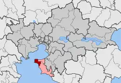 | |
| Coordinates: 40°28′N 22°52′E | |
| Country | Greece |
| Administrative region | Central Macedonia |
| Regional unit | Thessaloniki |
| Municipality | Thermaikos |
| • Municipal unit | 21.569 km2 (8.328 sq mi) |
| Population (2011)[1] | |
| • Municipal unit | 11,901 |
| • Municipal unit density | 550/km2 (1,400/sq mi) |
| Time zone | UTC+2 (EET) |
| • Summer (DST) | UTC+3 (EEST) |
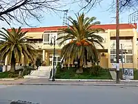
Town hall
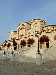
A church
References
- "Απογραφή Πληθυσμού - Κατοικιών 2011. ΜΟΝΙΜΟΣ Πληθυσμός" (in Greek). Hellenic Statistical Authority.
- Kallikratis law Greece Ministry of Interior (in Greek)
- "Population & housing census 2001 (incl. area and average elevation)" (PDF) (in Greek). National Statistical Service of Greece. Archived from the original (PDF) on 2015-09-21.
This article is issued from Wikipedia. The text is licensed under Creative Commons - Attribution - Sharealike. Additional terms may apply for the media files.