Michelsneukirchen
Michelsneukirchen is a municipality in Oberpfälzer district of Cham in Bavaria in Germany.
Michelsneukirchen | |
|---|---|
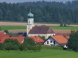 Saint Michael Church | |
 Coat of arms | |
Location of Michelsneukirchen within Cham district 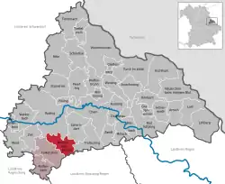 | |
 Michelsneukirchen  Michelsneukirchen | |
| Coordinates: 49°7′27″N 12°33′9″E | |
| Country | Germany |
| State | Bavaria |
| Admin. region | Oberpfalz |
| District | Cham |
| Municipal assoc. | Falkenstein, Bavaria |
| Government | |
| • Mayor | Gerhard Blab |
| Area | |
| • Total | 32.86 km2 (12.69 sq mi) |
| Elevation | 569 m (1,867 ft) |
| Population (2019-12-31)[1] | |
| • Total | 1,726 |
| • Density | 53/km2 (140/sq mi) |
| Time zone | UTC+01:00 (CET) |
| • Summer (DST) | UTC+02:00 (CEST) |
| Postal codes | 93185 |
| Dialling codes | 0 94 67 |
| Vehicle registration | CHA |
| Website | www.michelsneukirchen.de |
Geographical Facts
Geographical position
The village is located in the Bavarian Forest.
Adjoining Municipalities
Adjoining municipalities are Schorndorf, Falkenstein, Obertrübenbach and in Zinzenzell in Niederbayern.
Structuring of the Community
There are several small villages in Michelsneukirchen, for example Dörfling, Woppmannsdorf, Momannsfelden, Regelsmais and Ponholz.
History
The village belonged to the masters of Falkenstein.
Crest
Michelsneukirchen's crest is "divided by red and gold; a silver flaming sword in front, three tilted lozenges in the back."
Gastronomic Specialties
Grandma's mushroom soup with dumplings and apple pie for dessert.
References
- "Tabellenblatt "Daten 2", Statistischer Bericht A1200C 202041 Einwohnerzahlen der Gemeinden, Kreise und Regierungsbezirke". Bayerisches Landesamt für Statistik und Datenverarbeitung (in German). July 2020.
External links
Towns and municipalities in Cham (district) | ||
|---|---|---|
| Coat of Arms of Cham district | |
| Authority control |
|---|
This article is issued from Wikipedia. The text is licensed under Creative Commons - Attribution - Sharealike. Additional terms may apply for the media files.