Middle Fork Popo Agie River
The Middle Fork Popo Agie River is a river in Wyoming in the United States. The river is 54 miles (87 km)[3] long. The river is sometimes referred to as simply the 'Middle Fork'. The river is part of the Popo Agie Watershed[3] and from its headwaters in the Wind River Range until it joins with the North Fork of the Popo Agie River, the river and its tributaries irrigate roughly 11,503 acres.[3]
| Middle Fork Popo Agie River | |
|---|---|
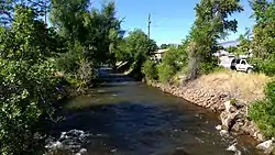 The Middle Fork Popo Agie River seen from Main Street in Lander Wyoming. | |
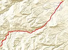 The Flow of the Middle Fork Popo Agie from source to confluence. | |
| Etymology | word po-PO-shuh, meaning "Head River"[1] or possibly "Gurgling River" [2] |
| Location | |
| Country | United States |
| State | Wyoming |
| City | Lander, Wyoming |
| Physical characteristics | |
| Source | Sweetwater Gap |
| • location | Wind River Range, Fremont County |
| • elevation | 12,000 ft (3,700 m) |
| Mouth | North Popo Agie River |
• location | Fort McGraw |
• coordinates | 42°51′14″N 108°42′00″W |
• elevation | 5,000 ft (1,500 m) |
| Length | 54 mi (87 km) |
| Basin features | |
| Tributaries | |
| • left | Baldwin Creek,[3] Beason Creek[3] |
| • right | Sawmill Creek,[3] Red Canyon Creek,[3]Roaring Fork Creek |
The river is notable for passing underground through a sinkhole in Sinks Canyon State Park, only to emerge several hundred yards downstream at "the rise." The ground distance is not far, but tests with dye have shown it takes the water many hours to flow through the underground passage.
Course
The Middle Fork is fed from spring sources, seasonal precipitation and annual snow melt, irrigation return flows, several tributaries including the Sawmill, Hornecker, and Baldwin Creeks, and the North Fork of the Popo Agie River.[4] A significant tributary comes from Roaring Fork Creek downstream of Worthen Meadow Reservoir.[5] The river's head is near Sweetwater Gap in the southern Wind River Range and it flows through the mountains, reaching Sinks Canyon and eventually Lander before joining the North Fork of the Popo Agie River to form the Popo Agie, or Big Popo Agie River.[4] The river then joins the Little Popo Agie River before its confluence at the Little Wind River.
History
The river has likely been known to native peoples for thousands of years. But one of the first written accounts comes from Benjamin Bonneville around 1833 when his expedition explored the Wind River region.[1] The word 'Popo', in the Crow language signifies 'Head' and 'Agie', means 'River'.[1] However, the name has also been translated as "Gurgling River"[2]
The Crow Tribe's Apsalooke Place Names Database at Little Bighorn College, which was created by Crow linguists and historians, records the name of the river as Poppootcháashe, an onomatopoeia meaning "plopping river" which describes the sound the river makes when it passes into the sinkhole in Sinks Canyon.[6]
Areas along the river were more extensively explored and documented during the Jones Expedition of 1873. The expedition's report describes geology along the river with detailed documentation of everything from Native American petroglyphs to early white settlements.[7] The report describes the area near the river as having rich soil with good potential for irrigation and a mild climate.[7]
Modern History
The river's flow and surrounding geological makeup have been studied for decades. By the early 20th Century, numerous minerals and other potential resources had been identified to possibly be developed.[8] Everything from Limestone and Marble mining to hydroelectric power potential had been studied along the river.[8]
Pollution
In April 2019, the Wyoming Department of Environmental Quality filed a notice of violation with Maverik Inc due to a gasoline leak on the river.[9] The department conducted tests and reviewed documents after it received reports of gasoline leaking into the river near a Maverick gas station on Main Street in Lander. The department concluded the leak was from an overfilled underground gasoline storage tank.[9]
Popular Culture
The Sinks of the Popo Agie figure into the climax of James Galvin's 2000 novel Fencing the Sky.[10]
See also
References
- Claude E. Jamison; Wyoming. State Geologist (1911). Bulletin. State Geologist. p. 7.
- "Sinks Canyon State Park History". Wyoming State Parks, Historic Sites & Trails. State of Wyoming. Retrieved Feb 28, 2017.
- "Popo Agie Hydrology". Popo Agie Conservation District. Popo Agie Conservation District. Retrieved Feb 28, 2017.
- "Middle Fork of the Popo Agie River Bacterial Monitoring Projects" (PDF). Middle Fork of the Popo Agie River. Popo Agie Conservation District. Retrieved Feb 28, 2017.
- ARIX Corporation (1987). LANDER REHABILITATION PROJECT LEVEL II FEASIBILITY STUDY (PDF). ARIX Corporation. p. 1.
- http://lib.lbhc.edu/index.php?q=node/200&a=P
- THE RECONNAISSANCE Of NORTHWESTERN WYOMING INCLUDING YELLOWSTONE NATIONAL PARK (Report). U.S. Government Printing Office. 1875.
- Claude E. Jamison; Wyoming. State Geologist (1911). Bulletin. State Geologist. p. 108.
- "DEQ files enforcement action in regard to gasoline spill that affected the Popo Agie River in Lander, WY". Wyoming DEQ. Retrieved Oct 18, 2019.
- https://us.macmillan.com/books/9781466854260
| Authority control |
|
|---|