Minnesota State Highway 156
Minnesota State Highway 156 (MN 156) is a 4.201-mile-long (6.761 km) highway in Minnesota, which runs from its interchange with Interstate 494 in South St. Paul and continues north to its northern terminus at its interchange with U.S. Highway 52 (the Lafayette Freeway) near downtown Saint Paul.
| ||||
|---|---|---|---|---|
| Concord Street | ||||
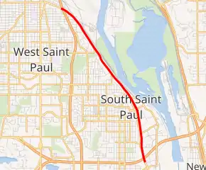
MN 156 highlighted in red | ||||
| Route information | ||||
| Maintained by MnDOT | ||||
| Length | 4.201 mi[1] (6.761 km) | |||
| Existed | 1994–present | |||
| Major junctions | ||||
| South end | ||||
| North end | ||||
| Location | ||||
| Counties | Dakota, Ramsey | |||
| Highway system | ||||
| ||||

The route passes through the cities of South St. Paul and Saint Paul.
Highway 156 is also known as Concord Street.
Route description
State Highway 156 serves as a north–south route between South St. Paul and the "West Side" neighborhood of Saint Paul.
Highway 156 generally follows the Mississippi River throughout its route.
History
State Highway 156 was marked in 1994. It was originally part of State Highway 56 from 1934 to 1994.
The route was renumbered 156 in 1994 when State Highway 56 was shortened to end at Hampton in southern Dakota County. Nearby Concord Boulevard in Inver Grove Heights (previously State Highway 56 as well) was designated Dakota County Road 56 in 1994.
The route has been paved since the 1920s before it was a numbered highway.[2]
The section that is Legislative Route 112 is currently being turned back.[3]
Major intersections
| County | Location | mi[1] | km | Destinations | Notes |
|---|---|---|---|---|---|
| Dakota | South St. Paul | 0.000– 0.060 | 0.000– 0.097 | I-494 exit 64B; interchange. | |
| 2.194 | 3.531 | CR 6 (Central Avenue) | |||
| 2.962 | 4.767 | CR 4 (Butler Avenue) | |||
| Ramsey | St. Paul | 4.108– 4.201 | 6.611– 6.761 | Interchange | |
| 1.000 mi = 1.609 km; 1.000 km = 0.621 mi | |||||
References
- "Trunk Highway Log Point Listing - Construction District 5" (PDF). Minnesota Department of Transportation. August 20, 2010. Archived from the original (PDF) on June 27, 2011. Retrieved November 21, 2010.
- Riner, Steve. "Details of routes 152–218". The Unofficial Minnesota Highways Page. Self-published. Retrieved November 21, 2010.
- "LEGISLATIVE ROUTE NO. 112 REMOVED".