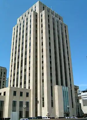
Ramsey County, Minnesota
Ramsey County is a county located in the U.S. state of Minnesota. As of the 2010 census, the population was 508,640,[2] making it the second-most populous county in Minnesota. Its county seat and largest city is Saint Paul,[3] the state capital. The county was founded in 1849 and is named for Alexander Ramsey, the first governor of the Minnesota Territory.[4]
Ramsey County | |
|---|---|
 | |
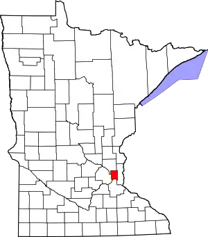 Location within the U.S. state of Minnesota | |
 Minnesota's location within the U.S. | |
| Coordinates: 45°01′N 93°06′W | |
| Country | |
| State | |
| Founded | October 27, 1849[1] |
| Named for | Alexander Ramsey |
| Seat | Saint Paul |
| Largest city | Saint Paul |
| Area | |
| • Total | 170 sq mi (400 km2) |
| • Land | 152 sq mi (390 km2) |
| • Water | 18 sq mi (50 km2) 11%% |
| Population (2010) | |
| • Total | 508,640 |
| • Estimate (2020) | 554,847 |
| • Density | 3,342/sq mi (1,290/km2) |
| Time zone | UTC−6 (Central) |
| • Summer (DST) | UTC−5 (CDT) |
| Congressional districts | 4th, 5th |
| Website | www |
Ramsey County is included in the Minneapolis–Saint Paul-Bloomington, MN-WI Metropolitan Statistical Area. It is the smallest and most densely populated county in Minnesota, as well as one of the most densely populated counties in the United States.[5]
History
With the establishment of the Minnesota Territory in 1849, nine counties, including Ramsey County, were created. In 1849, Ramsey County included all of what later became the present-day counties of Ramsey, Anoka, Isanti, and Kanabec; and part of Washington, Pine, Carlton, Aitkin, Mille Lacs, and Hennepin. One of Ramsey County's early settlers was Heman Gibbs, whose farm is now operated as the Gibbs Museum of Pioneer and Dakotah Life (Gibbs Farm [7]) in Falcon Heights. Ramsey County remained largely farmland until small villages began to appear in the late 19th century, with the incorporation of North St. Paul in 1887, New Brighton in 1891, and White Bear Lake in 1921.[8]
Government and politics
County Sheriff
The Ramsey County Sheriff is the top law enforcement official in Ramsey County. The Ramsey County Sheriff is elected for a four-year term via an election running concurrent with the federal mid-term elections.
The current sheriff is Bob Fletcher, who won the general election for Ramsey County Sheriff on November 6, 2018.
Providing safety in Ramsey County is a collaborative effort across multiple agencies. The Ramsey County Sheriff's office provides a number of unique services across the county as mandated by law. This includes detention for court and other court services. This also includes safety, rescue and law enforcement on the waterways.
Proactively, the Sheriff's office provides multiple safety classes and coordinates community volunteer efforts.
The sheriff's office provides patrol and investigation for communities without local police forces and is available as backup for all communities. An emergency 911 call will send the appropriate agency according to the caller's location and law enforcement availability.
| Community | Law Enforcement | Fire Protection | Ambulance |
|---|---|---|---|
| Arden Hills | Ramsey County Sheriff | Lake Johanna Fire | Allina Medical Transport |
| Falcon Heights | Ramsey County Sheriff | Falcon Heights Fire | Saint Paul Fire |
| Gem Lake | White Bear Lake Police | White Bear Lake Fire | White Bear Lake Fire |
| Lauderdale | Saint Anthony Police | Falcon Heights Fire | Saint Paul Fire |
| Little Canada | Ramsey County Sheriff | Little Canada Fire & Rescue | Allina Medical Transport |
| Maplewood | Maplewood Police | Maplewood Fire | Maplewood Fire |
| Minnesota State Fairgrounds | Minnesota State Fair Police | Saint Paul Fire | Saint Paul Fire |
| Mounds View | Mounds View Police | SBM Fire | Allina Medical Transport |
| New Brighton | New Brighton Police Division | New Brighton Fire Division | Allina Medical Transport |
| North Oaks | Ramsey County Sheriff | Lake Johanna Fire | Allina Medical Transport |
| North Saint Paul | North Saint Paul Police | North Saint Paul Fire | Lakeview Emergency Medical |
| Roseville | Roseville Police | Roseville Fire | Allina Medical Transport |
| Saint Anthony | Saint Anthony Police | Saint Anthony Fire | Hennepin EMS |
| Saint Paul | Saint Paul Police | Saint Paul Fire | Saint Paul Fire |
| Shoreview | Ramsey County Sheriff | Lake Johanna Fire | Allina Medical Transport |
| University of Minnesota-St. Paul | University Police | Saint Paul Fire | Saint Paul Fire |
| Vadnais Heights | Ramsey County Sheriff | Vadnais Heights Fire | Allina Medical Transport |
| White Bear Lake | White Bear Lake Police | White Bear Lake Fire | White Bear Lake Fire |
| White Bear Township | Ramsey County Sheriff | White Bear Lake Fire | White Bear Lake Fire |
County Attorney
The Ramsey County Attorney prosecutes felony crimes which are committed within the jurisdiction of Ramsey County. The current County Attorney is John Choi, who was elected in 2010.
County Commissioners
The county commission elects a chair who presides at meetings. Commissioners as of November 20, 2019:
| District | Commissioner | In office since | Current term expires on December 31 of |
|---|---|---|---|
| 1st | Nicole Joy Frethem | 2019 | 2020 |
| 2nd | Mary Jo McGuire | 2013 | 2020 |
| 3rd | Trista MatasCastillo | 2019 | 2022 |
| 4th | Toni Carter (Chair) | 2005 | 2022 |
| 5th | Rafael Ortega | 1995 | 2022 |
| 6th | Jim McDonough | 2000 | 2022 |
| 7th | Victoria Reinhardt | 1997 | 2020 |
| Year | Republican | Democratic | Third parties |
|---|---|---|---|
| 2020 | 26.1% 77,376 | 71.5% 211,620 | 2.4% 6,981 |
| 2016 | 26.0% 70,894 | 65.1% 177,738 | 9.0% 24,511 |
| 2012 | 31.1% 86,800 | 66.3% 184,938 | 2.5% 7,084 |
| 2008 | 32.1% 88,942 | 66.0% 182,974 | 2.0% 5,470 |
| 2004 | 35.6% 97,096 | 63.0% 171,846 | 1.3% 3,635 |
| 2000 | 35.9% 87,669 | 56.7% 138,470 | 7.4% 18,139 |
| 1996 | 29.3% 66,954 | 58.7% 133,878 | 12.0% 27,381 |
| 1992 | 27.1% 68,206 | 52.0% 130,932 | 21.0% 52,777 |
| 1988 | 37.8% 88,736 | 61.2% 143,767 | 1.0% 2,393 |
| 1984 | 40.0% 95,667 | 59.2% 141,623 | 0.9% 2,153 |
| 1980 | 33.9% 78,860 | 53.6% 124,774 | 12.5% 29,110 |
| 1976 | 37.9% 86,480 | 58.6% 133,682 | 3.5% 7,905 |
| 1972 | 45.6% 95,716 | 51.6% 108,392 | 2.8% 5,843 |
| 1968 | 32.8% 64,068 | 62.6% 122,568 | 4.6% 9,020 |
| 1964 | 29.7% 56,898 | 69.9% 133,948 | 0.4% 746 |
| 1960 | 41.5% 77,408 | 58.2% 108,464 | 0.4% 655 |
| 1956 | 47.7% 80,701 | 51.9% 87,784 | 0.3% 554 |
| 1952 | 44.4% 76,093 | 54.7% 93,783 | 0.9% 1,494 |
| 1948 | 34.2% 48,142 | 62.8% 88,528 | 3.0% 4,217 |
| 1944 | 39.7% 53,052 | 58.9% 78,759 | 1.5% 1,933 |
| 1940 | 41.3% 57,093 | 57.2% 78,990 | 1.5% 2,082 |
| 1936 | 23.4% 30,553 | 66.0% 86,286 | 10.6% 13,889 |
| 1932 | 35.7% 38,589 | 61.2% 66,128 | 3.0% 3,263 |
| 1928 | 47.8% 53,054 | 51.2% 56,807 | 1.0% 1,049 |
| 1924 | 47.7% 39,566 | 10.1% 8,407 | 42.2% 35,046 |
| 1920 | 58.6% 40,204 | 30.8% 21,110 | 10.6% 7,273 |
| 1916 | 35.1% 13,317 | 58.7% 22,291 | 6.2% 2,353 |
| 1912 | 12.7% 4,109 | 38.4% 12,431 | 48.9% 15,810[10] |
| 1908 | 54.6% 16,556 | 38.3% 11,613 | 7.0% 2,131 |
| 1904 | 70.2% 18,269 | 22.5% 5,860 | 7.3% 1,889 |
| 1900 | 56.3% 15,384 | 40.0% 10,931 | 3.8% 1,030 |
| 1896 | 57.7% 17,522 | 39.7% 12,048 | 2.7% 817 |
| 1892 | 42.0% 11,307 | 47.6% 12,817 | 10.4% 2,802 |
Geography
According to the U.S. Census Bureau, the county has a total area of 170 square miles (440 km2), of which 152 square miles (390 km2) is land and 18 square miles (47 km2) (11%) is water.[11] It is the smallest county by area in Minnesota. It has been considered completely urbanized since the 1990 United States Census.[12]
Adjacent counties
- Anoka County (north)
- Washington County (east)
- Dakota County (south)
- Hennepin County (west)
National protected area
Transportation
Ramsey County is served by several interstate highways, including Interstate 35 and Interstate 94. I-35 has two routes through Ramsey County. I-35E enters the county from Dakota County to the south and proceeds north through Saint Paul, where it intersects I-94, then continues north to Little Canada, where it runs east concurrently with I-694 for several miles before turning north through North Oaks to Washington County. I-35W crosses from Minneapolis to the west through Saint Anthony before turning north through New Brighton, where it intersects I-694, and then to Anoka County where it goes on to rejoin I-35E in Washington County.[13]
Near the western edge of the county, I-94 enters from Minneapolis where it runs almost parallel to University Avenue until it meets I-35E in Saint Paul and continues east to Washington County. I-494 passes through the southeast corner of the county between Dakota and Washington Counties. From Anoka County in the west, I-694 takes a path through New Brighton, where it meets I-35W, to the junction with I-35E in Little Canada and finally to Washington County in the east.[13]
Ramsey County is also accessible by several U.S. Highways, in particular US 10, US 52, and US 61. US 10 enters from Washington County in the south and continues north to meet I-94 just east of Saint Paul where it turns west to run concurrently with I-94, I-35E, I-694, and finally I-35W before continuing northwest to Anoka County. US 52 runs from South Saint Paul in Dakota County north to downtown Saint Paul where it meets I-94 and turns west to run concurrently with it all the way to the North Dakota border. From the south, US 61 runs concurrently with US 10 and then I-94 until it continues northeast on surface streets through the East Side of Saint Paul. From Saint Paul, US 61 continues north through Maplewood and White Bear Lake before crossing the border into Washington County.[13]
In addition to these federal highways, Ramsey County is served by a number of Minnesota State Highways, including MN 36 and MN 51 which are divided highways for much of their length.[13]
The county also has jurisdiction over 264.108 miles of County State Aid Highways as well as 21,031 miles of county roads and 59 bridges that are maintained and monitored by the Public Works Department of Ramsey County.[14]
Major highways
.svg.png.webp) Interstate 35E
Interstate 35E.svg.png.webp) Interstate 35W
Interstate 35W.svg.png.webp) Interstate 94
Interstate 94.svg.png.webp) Interstate 694
Interstate 694 U.S. Highway 10
 U.S. Highway 52
 U.S. Highway 61
 Minnesota State Highway 5
 Minnesota State Highway 13
 Minnesota State Highway 36
 Minnesota State Highway 51
 Minnesota State Highway 96
 Minnesota State Highway 120
 Minnesota State Highway 149
 Minnesota State Highway 156
 Minnesota State Highway 280
.svg.png.webp) County Road 30 (Larpenteur Avenue)
County Road 30 (Larpenteur Avenue).svg.png.webp) County Road 34 (University Avenue)
County Road 34 (University Avenue).svg.png.webp)
 County Road 36/37 (Shepard Road/Warner Road)
County Road 36/37 (Shepard Road/Warner Road)- Other county roads
Rail
Ramsey County is a major freight hub along BNSF's Northern Transcon route, as well as being served by Union Pacific and Canadian Pacific.[15]
Amtrak offers daily intercity passenger rail service on the Empire Builder from Union Depot in Saint Paul.[16] Light rail service is provided by Metro, a light rail and bus rapid transit system operated by Metro Transit that connects several communities in Ramsey and Hennepin Counties.[17]
Air
The primary airport serving Ramsey County is Minneapolis–Saint Paul International Airport, located in neighboring Hennepin County. The only airport located in Ramsey County is Saint Paul Downtown Airport, a smaller commercial airport with three runways primarily used for general aviation and military operations.[18]
Demographics
| Historical population | |||
|---|---|---|---|
| Census | Pop. | %± | |
| 1850 | 2,227 | — | |
| 1860 | 12,150 | 445.6% | |
| 1870 | 23,085 | 90.0% | |
| 1880 | 45,890 | 98.8% | |
| 1890 | 139,796 | 204.6% | |
| 1900 | 170,554 | 22.0% | |
| 1910 | 223,675 | 31.1% | |
| 1920 | 244,554 | 9.3% | |
| 1930 | 286,721 | 17.2% | |
| 1940 | 309,935 | 8.1% | |
| 1950 | 355,332 | 14.6% | |
| 1960 | 422,525 | 18.9% | |
| 1970 | 476,255 | 12.7% | |
| 1980 | 459,784 | −3.5% | |
| 1990 | 485,765 | 5.7% | |
| 2000 | 511,035 | 5.2% | |
| 2010 | 508,640 | −0.5% | |
| 2020 (est.) | 554,847 | [19] | 9.1% |
| U.S. Decennial Census[20] 1790-1960[21] 1900-1990[22] 1990-2000[23] 2010-2019[2] | |||
2010
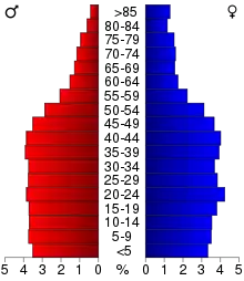
As of the 2010 Census, there were 508,640 people, 202,691 households, and 117,799 families living in the county. The racial makeup of the county was 70.1% White, 11.0% Black or African American, 0.8% Native American, 11.7% Asian, 2.9% from other races, and 3.5% from two or more races. 7.2% of the population were Hispanic or Latino of any race.
According to the 2010–2015 American Community Survey, the largest ancestry groups were was German (26.0%), Irish (11.5%), Norwegian (9.9%), and Swedish (7.4%).[24]
2000
At the 2000 Census, there were 511,035 people, 201,236 households, and 119,936 families living in the county. The population density was 3,281 people per square mile (1,267/km2). There were 206,448 housing units at an average density of 1,325 per square mile (512/km2). The racial makeup of the county was 77.37% White, 7.61% Black or African American, 0.83% Native American, 8.77% Asian, 0.06% Pacific Islander, 2.45% from other races, and 2.90% from two or more races. 5.28% of the population were Hispanic or Latino of any race.
There were 201,236 households, out of which 29.80% had children under the age of 18 living with them, 44.00% were married couples living together, 11.90% had a female householder with no husband present, and 40.40% were non-families. 32.00% of all households were made up of individuals, and 9.50% had someone living alone who was 65 years of age or older. The average household size was 2.45 and the average family size was 3.16.
In the county, the population was spread out, with 25.60% under the age of 18, 11.30% from 18 to 24, 30.70% from 25 to 44, 20.70% from 45 to 64, and 11.60% who were 65 years of age or older. The median age was 34 years. For every 100 females there were 93.00 males. For every 100 females age 18 and over, there were 89.20 males.
The median income for a household in the county was $45,722, and the median income for a family was $57,747. (These figures had risen to $53,141 and $71,485, respectively, as of 2008.) Males had a median income of $39,806 versus $30,814 for females. The per capita income for the county was $23,536. About 7.40% of families and 10.60% of the population were below the poverty line, including 15.70% of those under age 18 and 6.80% of those age 65 or over.
Communities
Cities
- Arden Hills
- Blaine (partial)
- Falcon Heights
- Gem Lake
- Lauderdale
- Little Canada
- Maplewood
- Mounds View
- New Brighton
- North Oaks
- North St. Paul
- Roseville
- Saint Paul (county seat)
- Shoreview
- Spring Lake Park (partial)
- St. Anthony (partial)
- Vadnais Heights
- White Bear Lake (partial)
Township
Unincorporated communities
Records
Ramsey County records are available for research use. They include school records, district and municipal court files, Board of Commissioners records, County Auditor records, Court of Common Pleas, probate court records, Saint Paul City Council records, and agency histories.
See also
References
- "Minnesota Place Names". Minnesota Historical Society. Archived from the original on June 20, 2012. Retrieved March 19, 2014.
- "State & County QuickFacts". United States Census Bureau. Archived from the original on July 17, 2011. Retrieved September 1, 2013.
- "Find a County". National Association of Counties. Retrieved June 7, 2011.
- Chicago and North Western Railway Company (1908). A History of the Origin of the Place Names Connected with the Chicago & North Western and Chicago, St. Paul, Minneapolis & Omaha Railways. p. 163.
- "Ramsey County". Metro MSP. Minneapolis Regional Chamber Development Foundation. 2008. Archived from the original on July 8, 2008. Retrieved February 23, 2011.
- Nelson, Steven (2011). Savanna Soils of Minnesota. Minnesota: Self. pp. 61 - 64. ISBN 978-0-615-50320-2.
- "Gibbs Farm". Ramsey County Historical Society. Retrieved 5 September 2020.
- Virginia Brainard Kunz. "A Brief History of Ramsey County". Ramsey County Historical Society. Archived from the original on December 30, 2017. Retrieved December 30, 2017.
- Leip, David. "Dave Leip's Atlas of U.S. Presidential Elections". uselectionatlas.org. Retrieved March 21, 2018.
- The leading "other" candidate, Progressive Theodore Roosevelt, received 12,426 votes, while Socialist candidate Eugene Debs received 2,942 votes, Prohibition candidate Eugene Chafin received 275 votes, and Socialist Labor candidate Arthur Reimer received 167 votes.
- "2010 Census Gazetteer Files". United States Census Bureau. August 22, 2012. Archived from the original on September 21, 2013. Retrieved October 24, 2014.
- "Ramsey County Public Works: A System of Thoroughfares, Highways, Streets and Other Public Ways". Ramsey County. Archived from the original on September 4, 2010. Retrieved January 25, 2011.
- "Ramsey County Highway Map" (PDF). Minnesota Department of Transportation. Archived from the original (PDF) on December 30, 2017. Retrieved December 30, 2017.
- "Ramsey County Public Works Department 2017 - 2021 Transportation Improvement Plan" (PDF). Ramsey County Public Works Department. Archived from the original (PDF) on December 30, 2017. Retrieved December 30, 2017.
- "Twin Cities Area Freight Railroad Map" (PDF). Minnesota Department of Transportation. September 2015. Archived from the original (PDF) on December 31, 2017. Retrieved December 30, 2017.
- "Empire Builder". Amtrak. Archived from the original on December 31, 2017. Retrieved December 30, 2017.
- "Twin Cities Metropolitan Area Transit System Map". Metro Transit. Archived from the original on December 31, 2017. Retrieved December 30, 2017.
- FAA Airport Form 5010 for STP PDF, effective Dec 7, 2017.
- "Population and Housing Unit Estimates". Retrieved March 26, 2020.
- "U.S. Decennial Census". United States Census Bureau. Retrieved October 24, 2014.
- "Historical Census Browser". University of Virginia Library. Retrieved October 24, 2014.
- "Population of Counties by Decennial Census: 1900 to 1990". United States Census Bureau. Retrieved October 24, 2014.
- "Census 2000 PHC-T-4. Ranking Tables for Counties: 1990 and 2000" (PDF). United States Census Bureau. Retrieved October 24, 2014.
- "2015 American Community Survey". Archived from the original on February 13, 2020. Retrieved August 22, 2017.
External links
Places adjacent to Ramsey County, Minnesota | ||||||||||
|---|---|---|---|---|---|---|---|---|---|---|
| ||||||||||
Municipalities and communities of Ramsey County, Minnesota, United States | ||
|---|---|---|
| Cities | Map of Minnesota highlighting Ramsey County | |
| Township | ||
| Unincorporated communities | ||
| Ghost towns/Neighborhoods | ||
| Footnotes | ‡This populated place also has portions in an adjacent county or counties | |
| ||

| Authority control |
|---|