Minnesota State Highway 336
Minnesota State Highway 336 (MN 336) is a short 2.251-mile-long (3.623 km) highway in northwest Minnesota, which runs from its interchange with Interstate 94/US Highway 52 near Moorhead and continues north to its interchange with U.S. Highway 10 near Dilworth and Glyndon.
| ||||
|---|---|---|---|---|
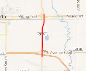
MN 336 highlighted in red | ||||
| Route information | ||||
| Defined by MS § 161.115(267) | ||||
| Maintained by MnDOT | ||||
| Length | 2.251 mi[1] (3.623 km) | |||
| Existed | June 4, 1991[2]–present | |||
| Major junctions | ||||
| South end | ||||
| North end | ||||
| Location | ||||
| Counties | Clay | |||
| Highway system | ||||
| ||||

Route description
Highway 336 serves as a short north–south connector route in northwest Minnesota, connecting Interstate 94 and U.S. 10, immediately east of the city of Moorhead. It is almost entirely located in Glyndon Township, except for briefly passing through the city limits of Dilworth.[1] The unincorporated community of Watts is located along the route. Highway 336 is located within the Fargo–Moorhead metro area.
Highway 336 is built as a four-lane divided highway with interchanges at each end. The roadway has always been a vital connection between Interstate 94 and U.S. 10, providing a gateway to nearby Detroit Lakes, a recreation destination area. Because it is a significant connector route with a high traffic volume, the short route is classified as part of the National Highway System.
The route is legally defined as Route 336 in the Minnesota Statutes.[3]
History
Highway 336 was authorized on June 4, 1991. It was routed along what was formerly part of County State-Aid Highway 11.[2] It was paved prior to becoming a state highway.[4]
Constant train activity and excessive weekend traffic not only deteriorated the roadway, but also caused major traffic headaches. In 2002, a reconstruction project began that expanded the roadway to four-lanes and added off-ramps to its junction with U.S. Highway 10 near Dilworth, as well as a new overpass constructed over the railroad crossing. In addition, the last 1/4 mile of Highway 336 at the north end was moved 350 feet (110 m) to the east to avoid demolition of a grain silo and an old farmstead which has since burned down.
Major intersections
The entire route is in Glyndon Township, Clay County.
| mi[1] | km | Destinations | Notes | ||
|---|---|---|---|---|---|
| 0.000 | 0.000 | Interchange; I-94 Exit 6; southern end of CSAH 11 concurrency | |||
| 2.251 | 3.623 | Interchange; northern end of CSAH 11 concurrency | |||
1.000 mi = 1.609 km; 1.000 km = 0.621 mi
| |||||
References
- Minnesota Department of Transportation (August 14, 2014). "Statewide Trunk Logpoint Listing" (PDF). St. Paul: Minnesota Department of Transportation. Retrieved November 16, 2015.
- "Chapter 339-H.F.No. 606". Laws of Minnesota 1991. Minnesota Office of the Revisor of Statutes. June 4, 1991. Retrieved January 25, 2011.
- "161.115, Additional Trunk Highways". Minnesota Statutes. Office of the Revisor of Statutes, State of Minnesota. 2010. Retrieved January 25, 2011.
- 1991-1992 Official Highway Map of Minnesota (Map). Minnesota Department of Transportation. 1991. § B10. Archived from the original on April 15, 2013. Retrieved January 25, 2011.