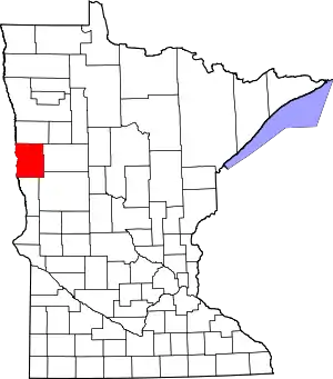
Clay County, Minnesota
Clay County is a county in the U.S. state of Minnesota. As of the 2010 United States Census, the population was 58,999.[2] Its county seat is Moorhead.[3]
Clay County | |
|---|---|
 | |
 Location within the U.S. state of Minnesota | |
 Minnesota's location within the U.S. | |
| Coordinates: 46°54′N 96°29′W | |
| Country | |
| State | |
| Founded | March 8, 1862 (created) 1872 (organized)[1] |
| Named for | Henry Clay |
| Seat | Moorhead |
| Largest city | Moorhead |
| Area | |
| • Total | 1,053 sq mi (2,730 km2) |
| • Land | 1,045 sq mi (2,710 km2) |
| • Water | 7.3 sq mi (19 km2) 0.7%% |
| Population (2010) | |
| • Total | 58,999 |
| • Estimate (2019) | 64,222 |
| • Density | 60.8/sq mi (23.5/km2) |
| Time zone | UTC−6 (Central) |
| • Summer (DST) | UTC−5 (CDT) |
| Congressional district | 7th |
| Website | www |
Clay County is part of the Fargo, ND-MN Metropolitan Statistical Area.
History
The county was formed on March 8, 1862, although its government was not organized at that time. In 1872, the organization was effected. It was named for nineteenth-century political figure Henry Clay,[4] member of the United States Senate from Kentucky, and US Secretary of State. The county was originally called Breckenridge, but soon (in 1862) was changed to Clay.
Geography
Clay County lies on the western side of Minnesota. Its western boundary line abuts the eastern boundary line of the state of North Dakota (across the Red River). The Red River flows northward along the western boundary line of the county, on its way to the Hudson Bay in Canada. The Buffalo River flows west-northwesterly through the center of the county, joined by the South Branch Buffalo River west of Glyndon, before discharging into the Red on the county's western border near Georgetown. The terrain consists of rolling hills, dotted with lakes and ponds in its eastern portion.[6] The terrain slopes to the west and north, with its highest point near the southeastern corner, at 1,430' (436m) ASL.[7] The county has a total area of 1,053 square miles (2,730 km2), of which 1,045 square miles (2,710 km2) are land and 7.3 square miles (19 km2) (0.7%) are covered by water.[8]
Adjacent counties
- Norman County - north
- Becker County - east
- Otter Tail County - southeast
- Wilkin County - south
- Richland County, North Dakota - southwest
- Cass County, North Dakota - west
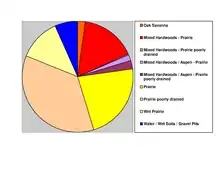
Protected areas[6]
- Aspen State Wildlife Management Area
- Bjornson State Wildlife Management Area
- Bluestone Prairie Scientific and Natural Area
- Clay County State Wildlife Management Area
- Cromwell State Wildlife Management Area
- Felton Prairie Scientific and Natural Area
- Goose Prairie State Wildlife Management Area
- Gruhl State Wildlife Management Area
- Hawley State Wildlife Management Area
- Hay Creek State Wildlife Management Area
- Highland State Wildlife Management Area
- Hitterdal State Wildlife Management Area
- Jeral State Wildlife Management Area
- Magnusson State Wildlife Management Area
- Skree State Wildlife Management Area
- Ulen State Wildlife Management Area
- Ulen Wildlife Refuge
Climate and weather
| Moorhead, Minnesota | ||||||||||||||||||||||||||||||||||||||||||||||||||||||||||||
|---|---|---|---|---|---|---|---|---|---|---|---|---|---|---|---|---|---|---|---|---|---|---|---|---|---|---|---|---|---|---|---|---|---|---|---|---|---|---|---|---|---|---|---|---|---|---|---|---|---|---|---|---|---|---|---|---|---|---|---|---|
| Climate chart (explanation) | ||||||||||||||||||||||||||||||||||||||||||||||||||||||||||||
| ||||||||||||||||||||||||||||||||||||||||||||||||||||||||||||
| ||||||||||||||||||||||||||||||||||||||||||||||||||||||||||||
In recent years, average temperatures in the county seat of Moorhead have ranged from a low of 0 °F (−18 °C) in January to a high of 82 °F (28 °C) in July, although a record low of −48 °F (−44 °C) was recorded in January 1887 and a record high of 114 °F (46 °C) was recorded in July 1936, the latter also the highest recorded temperature in the history of Minnesota. Average monthly precipitation ranged from 0.64 inches (16 mm) in February to 3.90 inches (99 mm) in June.[9]
Demographics
| Historical population | |||
|---|---|---|---|
| Census | Pop. | %± | |
| 1860 | 72 | — | |
| 1870 | 92 | 27.8% | |
| 1880 | 5,887 | 6,298.9% | |
| 1890 | 11,517 | 95.6% | |
| 1900 | 17,942 | 55.8% | |
| 1910 | 19,640 | 9.5% | |
| 1920 | 21,780 | 10.9% | |
| 1930 | 23,120 | 6.2% | |
| 1940 | 25,337 | 9.6% | |
| 1950 | 30,363 | 19.8% | |
| 1960 | 39,080 | 28.7% | |
| 1970 | 46,585 | 19.2% | |
| 1980 | 49,327 | 5.9% | |
| 1990 | 50,422 | 2.2% | |
| 2000 | 51,229 | 1.6% | |
| 2010 | 58,999 | 15.2% | |
| 2019 (est.) | 64,222 | [10] | 8.9% |
| US Decennial Census[11] 1790-1960[12] 1900-1990[13] 1990-2000[14] 2010-2019[2] | |||
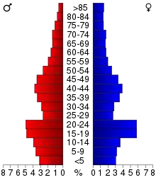
2000 census
As of the 2000 United States Census, there were 51,229 people, 18,670 households, and 12,340 families in the county. The population density was 49.0/sqmi (18.9/km2). There were 19,746 housing units at an average density of 18.9/sqmi (7.30/km2). The racial makeup of the county was 93.99% White, 0.52% Black or African American, 1.44% Native American, 0.88% Asian, 0.03% Pacific Islander, 1.67% from other races, and 1.47% from two or more races. 3.65% of the population were Hispanic or Latino of any race. 40.4% were of Norwegian and 26.8% German ancestry.
There were 18,670 households, out of which 33.80% had children under the age of 18 living with them, 53.90% were married couples living together, 8.80% had a female householder with no husband present, and 33.90% were non-families. 26.10% of all households were made up of individuals, and 10.60% had someone living alone who was 65 years of age or older. The average household size was 2.53 and the average family size was 3.07.
The county population contained 25.00% under the age of 18, 17.10% from 18 to 24, 25.70% from 25 to 44, 19.30% from 45 to 64, and 12.90% who were 65 years of age or older. The median age was 32 years. For every 100 females, there were 93.70 males. For every 100 females age 18 and over, there were 89.10 males.
The median income for a household in the county was $37,889, and the median income for a family was $49,192. Males had a median income of $34,176 versus $23,149 for females. The per capita income for the county was $17,557. About 7.40% of families and 13.20% of the population were below the poverty line, including 13.30% of those under age 18 and 7.50% of those age 65 or over.
Government and Politics
In national elections, Clay County has been a swing district for several decades. From 1992 to 2020, it has voted for the winner of the presidential election.
| Year | Republican | Democratic | Third parties |
|---|---|---|---|
| 2020 | 46.8% 15,043 | 50.9% 16,357 | 2.3% 738 |
| 2016 | 46.1% 13,543 | 44.1% 12,971 | 9.8% 2,884 |
| 2012 | 44.7% 12,920 | 52.7% 15,208 | 2.6% 758 |
| 2008 | 40.9% 11,978 | 57.0% 16,666 | 2.1% 615 |
| 2004 | 51.8% 14,365 | 46.8% 12,989 | 1.4% 383 |
| 2000 | 50.1% 11,712 | 43.4% 10,128 | 6.5% 1,518 |
| 1996 | 41.1% 8,764 | 49.1% 10,476 | 9.8% 2,079 |
| 1992 | 41.2% 9,666 | 41.9% 9,845 | 16.9% 3,967 |
| 1988 | 47.8% 10,380 | 51.5% 11,186 | 0.6% 139 |
| 1984 | 52.6% 11,565 | 46.8% 10,294 | 0.5% 119 |
| 1980 | 46.4% 10,447 | 39.7% 8,940 | 13.9% 3,121 |
| 1976 | 47.5% 10,317 | 50.1% 10,876 | 2.4% 515 |
| 1972 | 54.4% 11,089 | 44.5% 9,076 | 1.2% 235 |
| 1968 | 47.8% 7,910 | 48.2% 7,987 | 4.0% 663 |
| 1964 | 37.4% 6,085 | 62.4% 10,161 | 0.2% 39 |
| 1960 | 53.3% 8,278 | 46.6% 7,241 | 0.2% 25 |
| 1956 | 52.8% 6,783 | 47.1% 6,057 | 0.1% 15 |
| 1952 | 58.7% 7,178 | 41.2% 5,036 | 0.2% 20 |
| 1948 | 38.6% 4,302 | 59.4% 6,624 | 2.0% 219 |
| 1944 | 45.4% 4,392 | 54.1% 5,230 | 0.5% 52 |
| 1940 | 41.2% 4,450 | 58.3% 6,295 | 0.4% 48 |
| 1936 | 29.9% 2,880 | 65.3% 6,282 | 4.8% 459 |
| 1932 | 29.2% 2,556 | 67.8% 5,938 | 3.1% 270 |
| 1928 | 61.1% 5,057 | 37.8% 3,128 | 1.1% 87 |
| 1924 | 44.6% 3,081 | 6.4% 439 | 49.1% 3,396 |
| 1920 | 73.0% 4,943 | 19.7% 1,335 | 7.3% 493 |
| 1916 | 44.8% 1,549 | 49.6% 1,716 | 5.6% 193 |
| 1912 | 18.0% 549 | 30.9% 942 | 51.2% 1,561 |
| 1908 | 58.7% 1,857 | 35.6% 1,125 | 5.8% 182 |
| 1904 | 78.2% 2,185 | 13.9% 388 | 8.0% 223 |
| 1900 | 59.5% 1,903 | 36.4% 1,165 | 4.2% 133 |
| 1896 | 44.4% 1,594 | 53.1% 1,908 | 2.5% 90 |
| 1892 | 40.2% 959 | 24.9% 594 | 34.9% 833 |
| Position | Name | District | Next Election | |
|---|---|---|---|---|
| Commissioner and Vice Chair | Jim Haney | District 1 | 2020 | |
| Commissioner and Chairperson | Frank Gross | District 2 | 2020 | |
| Commissioner | Jenny Mongeau | District 3 | 2022 | |
| Commissioner | Kevin Campbell | District 4 | 2022 | |
| Commissioner | Grant Weyland | District 5 | 2020 | |
| Position | Name | Affiliation | District | |
|---|---|---|---|---|
| Senate | Kent Eken[17] | Democrat | District 4 | |
| House of Representatives | Ben Lien[18] | Democrat | District 4A | |
| House of Representatives | Paul Marquart[19] | Democrat | District 4B | |
| Position | Name | Affiliation | District | |
|---|---|---|---|---|
| House of Representatives | Collin Peterson[20] | Democrat | 7th | |
| Senate | Amy Klobuchar[21] | Democrat | N/A | |
| Senate | Tina Smith[22] | Democrat | N/A | |
Communities
Cities
Unincorporated communities
Townships
- Alliance Township
- Barnesville Township
- Cromwell Township
- Eglon Township
- Elkton Township
- Elmwood Township
- Felton Township
- Flowing Township
- Georgetown Township
- Glyndon Township
- Goose Prairie Township
- Hagen Township
- Hawley Township
- Highland Grove Township
- Holy Cross Township
- Humboldt Township
- Keene Township
- Kragnes Township
- Kurtz Township
- Moland Township
- Moorhead Township
- Morken Township
- Oakport Township
- Parke Township
- Riverton Township
- Skree Township
- Spring Prairie Township
- Tansem Township
- Ulen Township
- Viding Township
References
- "Minnesota Place Names". Minnesota Historical Society. Archived from the original on June 20, 2012. Retrieved March 17, 2014.
- "State & County QuickFacts". United States Census Bureau. Archived from the original on July 8, 2011. Retrieved August 31, 2013.
- "Find a County". National Association of Counties. Archived from the original on May 31, 2011. Retrieved June 7, 2011.
- Gannett, Henry (1905). The Origin of Certain Place Names in the United States. Govt. Print. Off. p. 83.
- Nelson, Steven (2011). Savanna Soils of Minnesota. Minnesota: Self. pp. 57-60. ISBN 978-0-615-50320-2.
- Clay County MN Google Maps (accessed 6 March 2019)
- ""Find an Altitude/Clay County MN" Google Maps (accessed March 6, 2019)". Archived from the original on May 21, 2019. Retrieved March 7, 2019.
- "2010 Census Gazetteer Files". US Census Bureau. August 22, 2012. Archived from the original on October 6, 2014. Retrieved October 6, 2014.
- "Monthly Averages for Moorhead MN". The Weather Channel. Retrieved November 6, 2011.
- "Population and Housing Unit Estimates". Retrieved March 26, 2020.
- "US Decennial Census". US Census Bureau. Archived from the original on April 26, 2015. Retrieved October 6, 2014.
- "Historical Census Browser". University of Virginia Library. Retrieved October 6, 2014.
- "Population of Counties by Decennial Census: 1900 to 1990". US Census Bureau. Retrieved October 6, 2014.
- "Census 2000 PHC-T-4. Ranking Tables for Counties: 1990 and 2000" (PDF). US Census Bureau. Retrieved October 6, 2014.
- Leip, David. "Atlas of US Presidential Elections". uselectionatlas.org. Retrieved April 17, 2018.
- "Board of Commissioners | Clay County, MN - Official Website". claycountymn.gov. Retrieved June 25, 2020.
- "MN State Senate". www.senate.mn. Retrieved June 25, 2020.
- "Rep. Ben Lien (04A) - Minnesota House of Representatives". www.house.leg.state.mn.us. Retrieved June 25, 2020.
- "Rep. Paul Marquart (04B) - Minnesota House of Representatives". www.house.leg.state.mn.us. Retrieved June 25, 2020.
- "Congressman Collin Peterson". Congressman Collin Peterson. Retrieved June 25, 2020.
- "U.S. Senator Amy Klobuchar". www.klobuchar.senate.gov. Retrieved June 24, 2020.
- "Home". Senator Tina Smith. Retrieved June 24, 2020.
External links
| Wikimedia Commons has media related to Clay County, Minnesota. |
Places adjacent to Clay County, Minnesota | ||||||||||
|---|---|---|---|---|---|---|---|---|---|---|
| ||||||||||
Municipalities and communities of Clay County, Minnesota, United States | ||
|---|---|---|
| Cities | Map of Minnesota highlighting Clay County | |
| Townships | ||
| CDPs | ||
| Unincorporated communities | ||
| Ghost towns | ||
| ||

| Counties | ||
|---|---|---|
| Main cities | ||
| Surrounding areas |
| |
‡ - county seat | ||
| Authority control |
|---|