Missouri Route 95
Route 95 is a highway in southern Missouri. Its northern terminus is at Route 32 at Lynchburg in Laclede County. Its southern terminus is at U.S. Route 160 at Lutie about 2.5 miles west of the Theodosia arm of Bull Shoals Lake in Ozark County.[1]
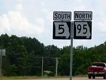
Wrong way concurrency sign on Missouri routes 5 and 95 at Wasola, Missouri
| ||||
|---|---|---|---|---|
| Route information | ||||
| Maintained by MoDOT | ||||
| Length | 93.051 mi (149.751 km) | |||
| Major junctions | ||||
| South end | ||||
| North end | ||||
| Highway system | ||||
| ||||

A short 3.3 miles (5.3 km) section forms a wrong-way concurrency with Route 5; Route 95 is marked as "North Route 95" but goes south at this location.
History
The section of Route 95 north of Wasola to Lutie was originally a section of Route 5A, a branch of Route 5.
Major intersections
| County | Location | mi[2] | km | Destinations | Notes |
|---|---|---|---|---|---|
| Ozark | Lutie | 0.000 | 0.000 | ||
| Wasola | 20.577 | 33.115 | Northern end of Route 5 overlap | ||
| Barren Fork Township | 23.822 | 38.338 | Southern end of Route 5 overlap | ||
| Douglas | Gentryville | 41.523 | 66.825 | ||
| Wood Township | 51.022 | 82.112 | |||
| Wright | Mountain Grove | 62.931 | 101.278 | ||
| 64.070 | 103.111 | ||||
| Van Buren Township | 76.037 | 122.370 | |||
| Laclede | Lynchburg | 93.051 | 149.751 | ||
1.000 mi = 1.609 km; 1.000 km = 0.621 mi
| |||||
References
- Ava, Missouri, 30x60 Minute Topographic Quadrangle, USGS, 1985
- Missouri Department of Transportation (December 28, 2020). MoDOT HPMAPS (Map). Missouri Department of Transportation. Retrieved December 28, 2020.
This article is issued from Wikipedia. The text is licensed under Creative Commons - Attribution - Sharealike. Additional terms may apply for the media files.