Mitford and Launditch Rural District
Mitford and Launditch Rural District was a rural district in Norfolk, England from 1894 to 1974.[1]
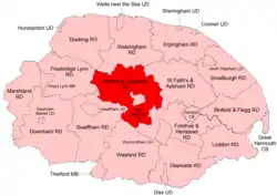 Position within Norfolk, 1935 Boundaries on 1935 map. |
It was formed under the Local Government Act 1894 based on the Mitford and Launditch rural sanitary district, taking its name from the two ancient hundreds of Mitford and Launditch. It completely encircled East Dereham Urban District.
The district was abolished under the Local Government Act 1972 and became part of the Breckland district. Its boundaries never changed during its 80 year existence.
Statistics
| Year | Area (ha) [2] |
Population [3] |
Density (pop/ha) |
|---|---|---|---|
| 1911 | 41,429 | 18,698 | 0.45 |
| 1921 | 17,945 | 0.43 | |
| 1931 | 17,107 | 0.41 | |
| 1951 | 18,113 | 0.44 | |
| 1961 | 17,651 | 0.43 |
Parishes
References
- "Mitford and Launditch RD through time: Census tables with data for the Local Government District". A Vision of Britain through Time. GB Historical GIS / University of Portsmouth. Retrieved 30 June 2017.
- "Mitford and Launditch RD through time: Population Statistics: Area (acres)". A Vision of Britain through Time. GB Historical GIS / University of Portsmouth. Retrieved 30 June 2017.
- "Mitford and Launditch RD through time: Population Statistics: Total Population". A Vision of Britain through Time. GB Historical GIS / University of Portsmouth. Retrieved 30 June 2017.
This article is issued from Wikipedia. The text is licensed under Creative Commons - Attribution - Sharealike. Additional terms may apply for the media files.