Lyng, Norfolk
Lyng is a village and civil parish in the English county of Norfolk. It is situated on the River Wensum, some 10 km (6.2 mi) north-east of the town of East Dereham and 20 km (12 mi) north-west of the city of Norwich.
| Lyng | |
|---|---|
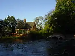 The Mill House on the River Wensum at Lyng | |
 Lyng Location within Norfolk | |
| Area | 7.99 km2 (3.08 sq mi) |
| Population | 807 (2011) |
| • Density | 101/km2 (260/sq mi) |
| OS grid reference | TG 068 176 |
| District | |
| Shire county | |
| Region | |
| Country | England |
| Sovereign state | United Kingdom |
| Post town | NORWICH |
| Postcode district | NR9 |
| Dialling code | 01603 |
| Police | Norfolk |
| Fire | Norfolk |
| Ambulance | East of England |
| UK Parliament | |
The civil parish has an area of 7.99 km2 (3.08 sq mi) and in the 2011 census had a population of 807 in 356 households. For the purposes of local government, the parish falls within the Elmham and Mattishall division of Norfolk County Council and the Upper Wensum ward of Breckland District Council.
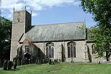
St. Margaret's Church and The Fox public house are located closer to the river with the shop located centrally in the village.
Churches
In medieval times Lyng had two churches. St. Edmund's Chapel, Lyng was the church of a Benedictine nunnery at Lyng Eastaugh to the south-east of the village. It fell into ruin when disused after being abandoned in the 13th century and all but a small stone pillar has disappeared.[1]
The church of Saint Margaret is still in use today and has regular services operated by the Church Of England. Externally, the church appears to be 17th to 18th century, due to a large renovation that took place around that time. The nave dates from the 15th century, when it was most probably enlarged from the original medieval church which stood there. Lyng St Margaret also houses an altar cloth which was made in the 19th century from at least two 15th-century vestments.[2]
Other features
Lyng also has a motocross track called Cadders Hills which is run by the Norwich Vikings motorcycle club which holds the British Motocross Championship and eastern centre championship and other events annually. The track is located to the south of the village and is situated in a natural valley with the natural Cadders Hill and woodland as its main feature.
Eastaugh
The hamlet of Eastaugh or Easthaugh, often known as Lyng Eastaugh, lies to the south-east of the main village near Weston Longville. It is the site of the ruin of the medieval chapel of St Edmund's.[1]
References
- Ruins of St Edmund's Chapel, Lyng and multi-period finds, Norfolk Heritage Explorer. Retrieved 2018-12-03.
- Parish Summary: Lyng, Norfolk Heritage Explorer. Retrieved 2018-12-03.
- ^ Ordnance Survey (1999). OS Explorer Map 238 - East Dereham & Aylsham. ISBN 0-319-21869-4.
- ^ Office for National Statistics & Norfolk County Council (2001). Census population and household counts for unparished urban areas and all parishes. Retrieved December 2, 2005.
External links
| Wikimedia Commons has media related to Lyng, Norfolk. |
- Map sources for Lyng, Norfolk
- Information from Genuki Norfolk on Lyng.