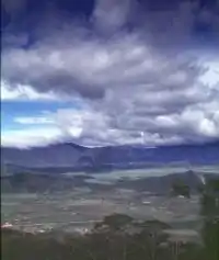
Moanemani
Moanemani is a village in the Kamu district of the Dogiyai Regency, Papua, Indonesia. It is located in the fertile Kamu Valley, a dry lake bed west of the Paniai lakes region. The indigenous residents are speakers of Mee. Moanemani is a major center for coffee production in Papua.[1] There is a local airport named the Moanamani airport.[2]
State conflict
In September 2012, the Indonesian army swept through the local area in search of a Free Papua Movement leader. Witnesses reported that troops forced villagers to shave and warned them to wear clean and new clothing.[3]
In May 2014, a truck ran over a group of church pilgrims, critically wounding three. The truck driver took refuge in the local Moanemani Brimob post. Riots ensued demanding the state release of the truck driver, although police refused.[4][5]
Climate
Moanemani has a subtropical highland climate (Cfb) with heavy rainfall year-round.
| Climate data for Moanemani | |||||||||||||
|---|---|---|---|---|---|---|---|---|---|---|---|---|---|
| Month | Jan | Feb | Mar | Apr | May | Jun | Jul | Aug | Sep | Oct | Nov | Dec | Year |
| Average high °C (°F) | 24.7 (76.5) |
24.7 (76.5) |
24.3 (75.7) |
23.9 (75.0) |
23.1 (73.6) |
21.9 (71.4) |
20.9 (69.6) |
21.1 (70.0) |
22.1 (71.8) |
23.5 (74.3) |
24.4 (75.9) |
24.7 (76.5) |
23.3 (73.9) |
| Daily mean °C (°F) | 19.6 (67.3) |
19.7 (67.5) |
19.5 (67.1) |
19.4 (66.9) |
18.9 (66.0) |
18.1 (64.6) |
17.4 (63.3) |
17.5 (63.5) |
17.9 (64.2) |
18.9 (66.0) |
19.4 (66.9) |
19.7 (67.5) |
18.8 (65.9) |
| Average low °C (°F) | 14.6 (58.3) |
14.7 (58.5) |
14.8 (58.6) |
14.9 (58.8) |
14.8 (58.6) |
14.4 (57.9) |
14.0 (57.2) |
13.9 (57.0) |
13.8 (56.8) |
14.3 (57.7) |
14.4 (57.9) |
14.7 (58.5) |
14.4 (58.0) |
| Average precipitation mm (inches) | 247 (9.7) |
313 (12.3) |
254 (10.0) |
269 (10.6) |
295 (11.6) |
329 (13.0) |
336 (13.2) |
329 (13.0) |
295 (11.6) |
247 (9.7) |
228 (9.0) |
217 (8.5) |
3,359 (132.2) |
| Source: Climate-Data.org[6] | |||||||||||||
References
- http://indonesiancoffee.net/coffee-in-indonesia.html
- "IATA Airport Code Search". International Air Transport Association. Retrieved May 3, 2016.
- "Paniai offensive intensifies as troops conduct house to house searches: reports". West Papua Media. September 6, 2012. Retrieved November 16, 2016.
- "Moenemani braces for security sweeps as Brimob shoot 3 relatives of 2 Dogiyai crash victims". West Papua Media. May 8, 2014. Retrieved November 16, 2016.
- [https://www.freewestpapua.org/actions/call-for-justice-for-three-innocent-civilians-shot-in-moanemani/
- "Climate: Moanemani". Climate-Data.org. Retrieved July 25, 2020.
