Moffet, Quebec
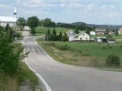
Moffet is a municipality in northwestern Quebec, Canada, in the Témiscamingue Regional County Municipality. The municipality had a population of 196 as of the Canada 2011 Census. Moffet consists of farming and cattle. With few stores in the town. Towns people mostly speak French, Quebec's official language. Few know English. The town is the home of Lac Chevreuil "Lake Deer" and neighbors Lac Simard. Over the years it has become a visitors spot for fishing and camping. Visitors come from other parts of Canada and parts of the United States. The town is very small; most people live on the main road that passes through Chemin De Moffet and Rue Principale. Some are scattered away from town, but not far away. Neighboring towns of Moffet are to the southwest is Latulipe-et-Gaboury and to the east Laforce.
Moffet | |
|---|---|
 | |
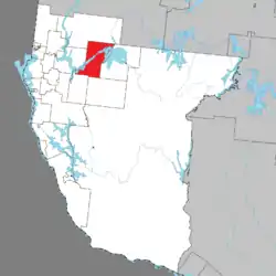 Location within Témiscamingue RCM. | |
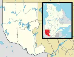 Moffet Location in western Quebec. | |
| Coordinates: 47°33′N 78°57′W[1] | |
| Country | |
| Province | |
| Region | Abitibi-Témiscamingue |
| RCM | Témiscamingue |
| Settled | 1936 |
| Constituted | January 1, 1953 |
| Government | |
| • Mayor | Alexandre Binette |
| • Federal riding | Abitibi—Témiscamingue |
| • Prov. riding | Rouyn-Noranda–Témiscamingue |
| Area | |
| • Total | 431.36 km2 (166.55 sq mi) |
| Population (2016)[3] | |
| • Total | 187 |
| • Density | 0.5/km2 (1/sq mi) |
| • Pop (2006–16) | |
| • Dwellings | 187 |
| Time zone | UTC−5 (EST) |
| • Summer (DST) | UTC−4 (EDT) |
| Postal code(s) | J0Z 2W0 |
| Area code(s) | 819 |
| Website | www |
Demographics
Population trend:[4]
- Population in 2016: 187
- Population in 2011: 196
- Population in 2006: 208
- Population in 2001: 234
- Population in 1996: 226
- Population in 1991: 246
Private dwellings occupied by usual residents: 90 (total dwellings: 193)
Mother tongue:[5]
- English as first language: 4.9%
- French as first language: 95.1%
- English and French as first language: 0%
- Other as first language: 0%
Wildlife
Moffet's town has wildlife like most other parts of Quebec. They have the national bird loons. They also have wolves, mink, bears, beavers, deer, and moose.
See also
References
- Reference number 41681 of the Commission de toponymie du Québec (in French)
- "Moffet". Répertoire des municipalités (in French). Ministère des Affaires municipales, des Régions et de l'Occupation du territoire. Archived from the original on 2012-06-01. Retrieved 2010-12-31.
- "Moffet census profile". 2011 Census data. Statistics Canada. Retrieved 2010-12-31.
- Statistics Canada: 1996, 2001, 2006 census, Population and dwelling count amendments, 2011
- "Moffet community profile". 2006 Census data. Statistics Canada. Retrieved 2010-12-31.
External links
Adjacent Municipal Subdivisions | ||||||||||
|---|---|---|---|---|---|---|---|---|---|---|
| ||||||||||
| Cities | |
|---|---|
| Municipalities | |
| Townships |
|
| Parishes | |
| Former municipalities |
|
| Unorganized territories | |
| |