Mogilno County
Mogilno County (Polish: powiat mogileński) is a unit of territorial administration and local government (powiat) in Kuyavian-Pomeranian Voivodeship, north-central Poland. It was formed on January 1, 1999, as a result of the Polish local government reforms passed in 1998. Its administrative seat and largest town is Mogilno, which lies 52 km (32 mi) south of Bydgoszcz and 62 km (39 mi) south-west of Toruń. The only other town in the county is Strzelno, lying 16 km (10 mi) east of Mogilno.
Mogilno County
Powiat mogileński | |
|---|---|
 | |
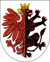
 Flag 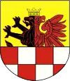 Coat of arms | |
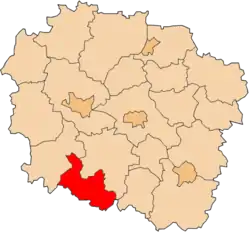 Location within the voivodeship | |
| Coordinates (Mogilno): 52°39′N 17°57′E | |
| Country | |
| Voivodeship | Kuyavian-Pomeranian |
| Seat | Mogilno |
| Gminas | |
| Area | |
| • Total | 675.86 km2 (260.95 sq mi) |
| Population (2006) | |
| • Total | 45,756 |
| • Density | 68/km2 (180/sq mi) |
| • Urban | 17,467 |
| • Rural | 28,289 |
| Car plates | CMG |
| Website | http://www.powiat.mogilno.pl |
The county covers an area of 675.86 square kilometres (261.0 sq mi). As of 2006 its total population is 45,756, out of which the population of Mogilno is 11,836, that of Strzelno is 5,631, and the rural population is 28,289.
Neighbouring counties
Mogilno County is bordered by Inowrocław County to the north-east, Konin County and Słupca County to the south, Gniezno County to the west, and Żnin County to the north-west.
Administrative division
The county is subdivided into four gminas (two urban-rural and two rural). These are listed in the following table, in descending order of population.
| Gmina | Type | Area (km²) |
Population (2019) |
Seat |
| Gmina Mogilno | urban-rural | 256.1 | 24,632 | Mogilno |
| Gmina Strzelno | urban-rural | 185.3 | 11,605 | Strzelno |
| Gmina Jeziora Wielkie | rural | 124.0 | 4,897 | Jeziora Wielkie |
| Gmina Dąbrowa | rural | 110.5 | 4,622 | Dąbrowa |