Molauer Land
Molauer Land is a municipality in the Burgenlandkreis district, in Saxony-Anhalt, Germany. It was formed on 1 January 2010 by the merger of the former municipalities Abtlöbnitz, Casekirchen, Leislau and Molau.

Molauer Land | |
|---|---|
Location of Molauer Land within Burgenlandkreis district 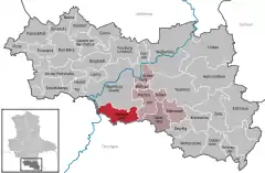 | |
 Molauer Land  Molauer Land | |
| Coordinates: 51°4′N 11°52′E | |
| Country | Germany |
| State | Saxony-Anhalt |
| District | Burgenlandkreis |
| Municipal assoc. | Wethautal |
| Subdivisions | 2 |
| Government | |
| • Mayor | Rolf Werner |
| Area | |
| • Total | 33.94 km2 (13.10 sq mi) |
| Elevation | 220 m (720 ft) |
| Population (2019-12-31)[1] | |
| • Total | 1,046 |
| • Density | 31/km2 (80/sq mi) |
| Time zone | UTC+01:00 (CET) |
| • Summer (DST) | UTC+02:00 (CEST) |
| Postal codes | 06618 |
| Dialling codes | 036694 |
| Vehicle registration | BLK |
| Website | www.vgem-wethautal.de |
References
- "Bevölkerung der Gemeinden – Stand: 31. Dezember 2019" (PDF). Statistisches Landesamt Sachsen-Anhalt (in German).
| Authority control |
|
|---|
This article is issued from Wikipedia. The text is licensed under Creative Commons - Attribution - Sharealike. Additional terms may apply for the media files.
