Montana Highway 49
Highway 49 (MT 49) in the U.S. State of Montana is a route running in a northerly direction from a junction with U.S. Route 2 in the town of East Glacier Park. The highway extends approximately 12 miles (19 km) to an intersection with U.S. Route 89 at a location known as Kiowa. Highway 49 is near the southeastern corner of Glacier National Park, and is heavily used by tourists during the summer months. A spur road heading west from Montana 49 four miles (6 km) north of East Glacier provides access to the Two Medicine area of the park.[2]
| ||||
|---|---|---|---|---|
| Looking Glass Hill Road | ||||
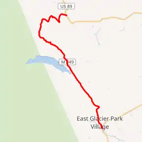
MT 49 highlighted in red | ||||
| Route information | ||||
| Maintained by MDT | ||||
| Length | 11.734 mi[1] (18.884 km) | |||
| Major junctions | ||||
| South end | ||||
| North end | ||||
| Location | ||||
| Counties | Glacier | |||
| Highway system | ||||
| ||||

Much of the route is steep, narrow, and winding, and prone to landslides. The northerly eight miles (13 km) of the route, passing over Looking Glass Hill, is unmaintained and usually impassable during the winter months.
Highway 49 was once part of the alignment of U.S. 2, prior to the construction of a highway bridge across Two Medicine Creek, which allowed for a more direct route between East Glacier and Browning.
Major intersections
The entire route is in Glacier County.
| Location | mi[1] | km | Destinations | Notes | |
|---|---|---|---|---|---|
| East Glacier Park Village | 0.000 | 0.000 | |||
| Kiowa | 11.734 | 18.884 | |||
| 1.000 mi = 1.609 km; 1.000 km = 0.621 mi | |||||
Images
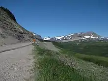
 Northern terminus in Kiowa
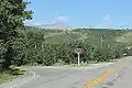
 Southern terminus at East Glacier Village
References
| Wikimedia Commons has media related to Montana Highway 49. |
- "Montana Off System Routes" (GIS data). Montana Department of Transportation. Retrieved April 7, 2017.
- Official 2007-2008 Montana Highway Travel Map (PDF) (Map). Montana Department of Transportation. Retrieved January 31, 2008.