Monte Lema
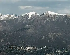
Monte Lema (1,621 m) is a mountain of the Lugano Prealps, located on the border between Switzerland and Italy. Its summit can easily reached by cable car from the village of Miglieglia (Ticino).
| Monte Lema | |
|---|---|
 | |
| Highest point | |
| Elevation | 1,621 m (5,318 ft) |
| Prominence | 140 m (460 ft) [1] |
| Parent peak | Monte Tamaro |
| Isolation | 0.95 km (0.59 mi) |
| Coordinates | 46°2′24.2″N 8°49′54.4″E |
| Geography | |
 Monte Lema Location in the Alps | |
| Location | Ticino, Switzerland Lombardy, Italy |
| Parent range | Lugano Prealps |
| Climbing | |
| Easiest route | Aerial tramway |
SOIUSA classification
According to the SOIUSA (International Standardized Mountain Subdivision of the Alps) the mountain can be classified in the following way:[2]
- main part = Western Alps
- major sector = North Western Alps
- section = Lugano Prealps
- subsection = Prealpi Varesine
- supergroup = Catena Tamaro-Gambarogno-Lema
- group = Gruppo del Tamaro
- subgroup = Gruppo del Lema
- code = I/B-11.II-A.1.c
Notes
External links
| Wikimedia Commons has media related to Monte Lema. |
This article is issued from Wikipedia. The text is licensed under Creative Commons - Attribution - Sharealike. Additional terms may apply for the media files.