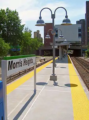
Morris Heights station
The Morris Heights station (also known as Morris Heights–West 177th Street station) is a commuter rail stop on the Metro-North Railroad's Hudson Line, serving the Morris Heights neighborhood of the Bronx, New York City. It is 8.1 miles (13.0 km) from Grand Central Terminal and travel time to Grand Central is approximately 17 minutes.
Morris Heights | ||||||||||||||||||||||||||||||||||||||||||||||||||||||||||||||||||
|---|---|---|---|---|---|---|---|---|---|---|---|---|---|---|---|---|---|---|---|---|---|---|---|---|---|---|---|---|---|---|---|---|---|---|---|---|---|---|---|---|---|---|---|---|---|---|---|---|---|---|---|---|---|---|---|---|---|---|---|---|---|---|---|---|---|---|
 The Morris Heights Metro-North station | ||||||||||||||||||||||||||||||||||||||||||||||||||||||||||||||||||
| Location | 229 West Tremont Avenue, Morris Heights, Bronx, New York | |||||||||||||||||||||||||||||||||||||||||||||||||||||||||||||||||
| Coordinates | 40.8540°N 73.9199°W | |||||||||||||||||||||||||||||||||||||||||||||||||||||||||||||||||
| Line(s) | Hudson Line | |||||||||||||||||||||||||||||||||||||||||||||||||||||||||||||||||
| Platforms | 1 island platform | |||||||||||||||||||||||||||||||||||||||||||||||||||||||||||||||||
| Tracks | 3 | |||||||||||||||||||||||||||||||||||||||||||||||||||||||||||||||||
| Connections | New York City Bus: Bx18, Bx40, Bx42 | |||||||||||||||||||||||||||||||||||||||||||||||||||||||||||||||||
| Other information | ||||||||||||||||||||||||||||||||||||||||||||||||||||||||||||||||||
| Fare zone | 2 | |||||||||||||||||||||||||||||||||||||||||||||||||||||||||||||||||
| Electrified | 700V (DC) third rail | |||||||||||||||||||||||||||||||||||||||||||||||||||||||||||||||||
| Passengers | ||||||||||||||||||||||||||||||||||||||||||||||||||||||||||||||||||
| 2006 | 6,760 | |||||||||||||||||||||||||||||||||||||||||||||||||||||||||||||||||
| Services | ||||||||||||||||||||||||||||||||||||||||||||||||||||||||||||||||||
| ||||||||||||||||||||||||||||||||||||||||||||||||||||||||||||||||||
| Former services | ||||||||||||||||||||||||||||||||||||||||||||||||||||||||||||||||||
| ||||||||||||||||||||||||||||||||||||||||||||||||||||||||||||||||||
| ||||||||||||||||||||||||||||||||||||||||||||||||||||||||||||||||||
It is located in the narrow strip of land between the Major Deegan Expressway and the Harlem River, next to Roberto Clemente State Park. It is also located across from the Dr Roland N. Patterson School complex, which was built over the tracks between the bridges for Harlem River Park Drive and West Tremont Avenue.
The station has operated since the days of the Spuyten Duyvil and Port Morris Railroad as well as the New York and Putnam Railroad late in the 19th century, though not in its present form.[1]
Station layout
This station has one narrow, 4-car-long high-level island platform[2]:1 accessible from West Tremont Avenue (West 177th Street).
| G | Street level | Exit/entrance |
| P Platform level |
Track 1 | ← Hudson Line toward Croton–Harmon (University Heights) |
| Island platform | ||
| Track 2 | Hudson Line toward Grand Central (Yankees–East 153rd Street) → | |
| Track 4 | ← Hudson Line express service does not stop here → | |
References
- Bronx Railroad Stations (Brennan's Abandoned Stations web-site)
- "Metro-North Railroad Track & Structures Department Track Charts Maintenance Program Interlocking Diagrams & Yard Diagrams 2015" (PDF). Metro-North Railroad. 2015. Retrieved January 28, 2019.
External links
 Media related to Morris Heights (Metro-North station) at Wikimedia Commons
- Metro-North station page for Morris Heights
- List of upcoming Metro-North train departure times and track assignments from MTA
- West Tremont Avenue entrance from Google Maps Street View