Motu Kō
Motu Kō is one of three islands in the Pukapuka atoll of the Cook Islands. It forms the southern apex of Pukapuka's triangular atoll, 10km south of Wale, and is the largest of the three islands.[1] The island is low-lying, with a maximum elevation of 5m above sea level and most of it only one or two metres.[2] It is uninhabited and used as a food source, regulated by the village of Ngake.[3]
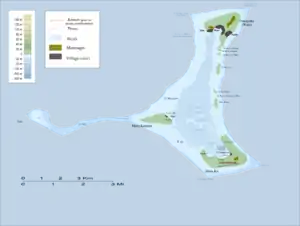
Map of Pukapuka Atoll
Pukapuka Island Airfield is located on Motu Kō.
References
- "Pukapuka - Frisbie's Island of Desire". Air Rarotonga. Retrieved 18 August 2020.
- "Cyclone Management Report for Pukapuka Atoll, Cook Islands and the Cook Islands National Disaster Management Office". Cook Islands National Disaster Management Office. August 1998. Retrieved 18 August 2020.
- "The motus of Pukapuka". Cook Islands News. 30 March 2012. Retrieved 18 August 2020.
This article is issued from Wikipedia. The text is licensed under Creative Commons - Attribution - Sharealike. Additional terms may apply for the media files.
