Mount Archibald
Mount Archibald is a prominent 2,588-metre (8,491-foot) mountain summit located in the Kluane Ranges of the Saint Elias Mountains in Yukon, Canada.[2] The mountain is situated 21 km (13 mi) west of Haines Junction, 5.9 km (4 mi) south of Mount Decoeli, and 27 km (17 mi) east-southeast of Mount Cairnes, which is the nearest higher peak.[3] Set on the boundary line of Kluane National Park, Archibald can be seen from the Alaska Highway, weather permitting. The mountain was named after Edgar Archibald (1885-1968), a Canadian agricultural scientist.[4] The mountain's name was officially adopted August 12, 1980, by the Geographical Names Board of Canada.[2] On a clear day, the summit offers views deep into Kluane National Park of giants such as Mt. Logan, Mt. Vancouver, and Mt. Kennedy.
| Mount Archibald | |
|---|---|
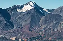 Mount Archibald, east aspect | |
| Highest point | |
| Elevation | 2,588 m (8,491 ft) [1] |
| Prominence | 1,678 m (5,505 ft) [1] |
| Parent peak | Mount Cairnes (2810 m)[1] |
| Listing |
|
| Coordinates | 60°47′03″N 137°52′27″W [2] |
| Geography | |
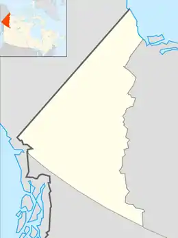 Mount Archibald Location in Yukon, Canada | |
| Location | Yukon, Canada |
| Parent range | Kluane Ranges Saint Elias Mountains[3] |
| Topo map | NTS 115A/13[2] |
Climate
Based on the Köppen climate classification, Mount Archibald is located in a subarctic climate zone with long, cold, snowy winters, and mild summers.[5] The annual average temperature in the neighborhood is -6 ° C. The warmest month is July, when the average temperature is 8 °C, and the coldest is December when temperatures can drop below −20 °C with wind chill factors below −30 °C. Precipitation runoff from the peak and meltwater from its surrounding glaciers drains into tributaries of the Alsek River.
References
- "Mount Archibald". Bivouac.com. Retrieved 2019-12-08.
- "Mount Archibald". Geographical Names Data Base. Natural Resources Canada. Retrieved 2019-12-08.
- "Mount Archibald, Yukon Territory". Peakbagger.com. Retrieved 2019-12-08.
- Chilliwack Progress newspaper, 11 June 1947
- Peel, M. C.; Finlayson, B. L.; McMahon, T. A. (2007). "Updated world map of the Köppen−Geiger climate classification". Hydrol. Earth Syst. Sci. 11: 1633–1644. ISSN 1027-5606.
External links
- Parks Canada: Kluane National Park
- Weather forecast: Mount Archibald
- Climbing Mt. Archibald: yukonhiking.ca
