Mount Iō (Iōjima)
Mount Iō (硫黄岳, Iō-dake) also Mount Iwo is an active rhyolitic lava dome on Iōjima in Kagoshima Prefecture, Japan. It sits within the borders of the town of Mishima.
| Mount Iō | |
|---|---|
| 硫黄岳 | |
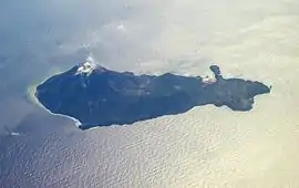
 Aerial view of Iōjima with Mount Iō steaming.(February 2008) | |
| Highest point | |
| Elevation | 703.7 m (2,309 ft) [1] |
| Prominence | 704 m (2,310 ft) |
| Listing | List of mountains and hills of Japan by height |
| Coordinates | 30°47′35″N 130°18′19″E [1] |
| Naming | |
| English translation | Sulphur Mountain |
| Language of name | Japanese |
| Geography | |
| Location | Iōjima, Kagoshima Prefecture, Japan |
| Parent range | Kikai Caldera |
| Topo map | Geographical Survey Institute, 25000:1 薩摩硫黄島, 50000:1 開聞岳 |
| Geology | |
| Age of rock | Holocene |
| Mountain type | Stratovolcano |
| Volcanic arc/belt | Ryukyu arc |
| Last eruption | June 2013 |

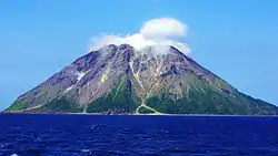
Mount Iō. May, 2015. Taken from the east.
The mountain is made up of non-alkali felsic rock and pyroclasitic flows.[2]
References
- Geographical Survey Institute map 25000:1 薩摩硫黄島, last access 9 January 2009
- "Kyushu". Seamless Digital Geographical Map of Japan. Geological Survey of Japan AIST. 2007. Retrieved 2009-01-13.
- VolcanoWorld - Kikai, Kyūshū, Japan
- S. Hamasaki, Volcanic-related alteration and geochemistry of Iwodake volcano, Satsuma-Iwojima, Kyushu, SW Japan, Earth Planets Space, pp 217–229, 2002, Tsukuba, Research Center for Deep Geological Environments, Geological Survey of Japan, AIST,
External links
- Satsuma-Iojima - Japan Meteorological Agency (in Japanese)
- "Satsuma-Iojima: National catalogue of the active volcanoes in Japan" (PDF). - Japan Meteorological Agency
- Satsuma-iojima - Geological Survey of Japan
- Kikai - Geological Survey of Japan
- Kikai: Global Volcanism Program - Smithsonian Institution
This article is issued from Wikipedia. The text is licensed under Creative Commons - Attribution - Sharealike. Additional terms may apply for the media files.