Mount Karisimbi
Mount Karisimbi is a stratovolcano in the Virunga Mountains on the border between Rwanda and the Democratic Republic of Congo. It is currently dormant. At 4,507 metres (14,787 ft), Karisimbi is the highest of the eight major mountains of the mountain range, which is a part of Albertine Rift, the western branch of the East African Rift. Karisimbi is flanked by Mikeno to the north, Bisoke to the east and Nyiragongo to the west, on the other side of the Rift Valley. Karisimbi is the 11th highest mountain of Africa.
| Mount Karisimbi | |
|---|---|
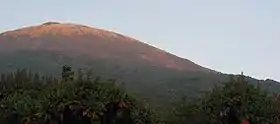 Karisimbi summit seen from the campsite in 2005 | |
| Highest point | |
| Elevation | 4,507 m (14,787 ft) [1] |
| Prominence | 3,312 m (10,866 ft) [1] Ranked 61st |
| Isolation | 207 km (129 mi) |
| Listing | Country high point Ultra |
| Coordinates | 1°30′30″S 29°26′42″E [1] |
| Geography | |
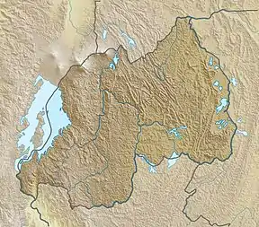 Mount Karisimbi Location of Mount Karisimbi in Rwanda (on the border with the DRC) | |
| Location | Democratic Republic of the Congo - Rwanda border |
| Parent range | Virunga Mountains |
| Geology | |
| Mountain type | Stratovolcano |
| Last eruption | 8050 BCE (?) |
The name Karisimbi comes from the word 'amasimbi' in the local language, Kinyarwanda, which means snow. Snow can mostly be found during the dry season in June, July and August on the top of the volcano.
Between Karisimbi and Bisoke is the Karisoke Research Center, which was founded by Dian Fossey in order to observe the mountain gorillas living in this area.
1908 expedition
On February 27, 1908 an expedition led by Egon Von Kirschstein was coming down the Branca Crater when a hailstorm and snowstorm caused twenty of the expedition's porters to perish.[2][3]
Notes
References
- "Karisimbi". Global Volcanism Program. Smithsonian Institution.
- "Volcan Karisimbi, Rwanda/Congo DRC". Peakbagger.com. Retrieved 2013-02-10.