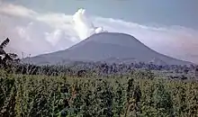
Mount Nyiragongo
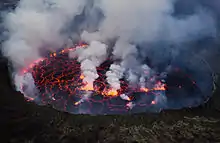
Mount Nyiragongo is an active stratovolcano with an elevation of 3,470 m (11,385 ft)[1] in the Virunga Mountains associated with the Albertine Rift. It is located inside Virunga National Park, in the Democratic Republic of the Congo, about 20 km (12 mi) north of the town of Goma and Lake Kivu and just west of the border with Rwanda. The main crater is about two kilometres (1 mi) wide and usually contains a lava lake. The crater presently has two distinct cooled lava benches within the crater walls – one at about 3,175 m (10,417 ft) and a lower one at about 2,975 m (9,760 ft). Nyiragongo's lava lake has at times been the most voluminous known lava lake in recent history. The depth of the lava lake varies considerably. A maximum elevation of the lava lake was recorded at about 3,250 m (10,660 ft) prior to the January 1977 eruption – a lake depth of about 600 m (2,000 ft). Following the January 2002 eruption, the lava lake was recorded at a low of about 2,600 m (8,500 ft), or 900 m (3,000 ft) below the rim.[2] The level has gradually risen since then.[3] Nyiragongo and nearby Nyamuragira are together responsible for 40 per cent of Africa's historical volcanic eruptions.[4]
| Mount Nyiragongo | |
|---|---|
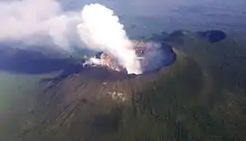 An aerial view of the volcanic peak | |
| Highest point | |
| Elevation | 3,470 m (11,385 ft) [1] |
| Coordinates | 1°31′09″S 29°15′15″E [1] |
| Geography | |
 Mount Nyiragongo | |
| Parent range | Virunga Mountains |
| Geology | |
| Mountain type | Stratovolcano |
| Last eruption | May 2002 – present[1] |
Geology
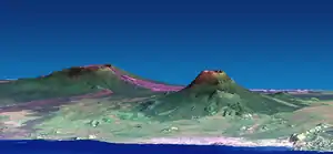
The volcano partly overlaps with two older volcanoes, Baratu and Shaheru, and is also surrounded by hundreds of small volcanic cinder cones from flank eruptions.
Nyiragongo's cone consists of pyroclastics and lava flows.[5] Nyiragongo's lavas are low-silica, alkali-rich, ultramafic extrusive rocks essentially free of feldspars. They range from olivine-rich melilitites through leucites to nephelinites, containing, in various proportions mainly the minerals nepheline, leucite, melilite, kalsilite, and clinopyroxene.[5][6][7] This very low silica composition results in eruptions with unusually fluid flows. Whereas most lava flows move rather slowly and rarely pose a danger to human life, Nyiragongo's lava flows may race downhill at up to 100 km/h (60 mph).[8]
.svg.png.webp)
Active history
Not much is known about how long the volcano has been erupting, but since 1882, it has erupted at least 34 times, including many periods where activity was continuous for years at a time, often in the form of a churning lava lake in the crater. The existence of the lava lake had been suspected for some time but was not scientifically confirmed until 1948.[9] At that time, it was measured at nearly 120,000 square metres (1.3×10⁶ sq ft).[9] Subsequent expeditions showed that the lake fluctuated in size, depth, and temperature over time.[9]
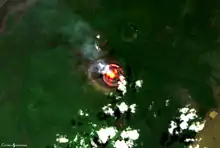
The lava lake activity is on-going.[10][3][11] As of 2020, the lake is mostly confined within a broad, steep-sided cinder cone (roughly 18 m (60 ft) high by 180 m (600 ft) wide) on the crater floor.[11][12]
1977 eruption
Between 1894 and 1977 the crater contained an active lava lake. On 10 January 1977, the crater walls fractured, and the lava lake drained in less than an hour.[1] The lava flowed down the flanks of the volcano at speeds of up to 60 kilometres per hour (37 mph) on the upper slopes, the fastest lava flow recorded to date,[13] overwhelming villages and killing at least 70 people. Within 30 minutes, the lava lake had emptied, flowing north, south, and west of the volcano. Nowhere else in the world does such a steep-sided stratovolcano contain a lake of such fluid lava. Nyiragongo's proximity to heavily populated areas increases its potential for causing a natural disaster. The 1977 eruption raised awareness of the unique dangers posed by Nyiragongo, and because of this, in 1991 it was designated a Decade Volcano, worthy of particular study.[14]
The 1977 eruption was preceded by the creation of a new small volcanic vent, Murara, a short distance away on the slopes of Nyamuragira.[15]
2002 eruptions
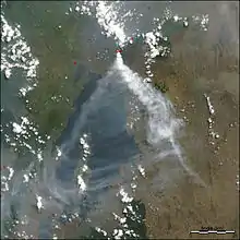
Lava lakes reformed in the crater in eruptions in 1982–1983 and 1994. Another major eruption of the volcano began on 17 January 2002, after several months of increased seismic and fumarolic activity. A 13 kilometres (8.1 mi) fissure opened in the south flank of the volcano, spreading in a few hours from 2,800 to 1,550 metres (9,190 to 5,090 ft) elevation and reaching the outskirts of the city of Goma, the provincial capital on the northern shore of Lake Kivu. Lava streamed from three spatter cones at the end of the fissure and flowed in a stream 200 to 1,000 metres (660 to 3,280 ft) wide and up to 2 metres (6 ft 7 in) deep through Goma. Warnings had been given and 400,000 people were evacuated from the city across the Rwandan border into neighbouring Gisenyi during the eruption. Lava covered the northern end of the runway at Goma International Airport, leaving the southern two-thirds usable, and reached Lake Kivu.[16] This raised fears that the lava might cause gas-saturated waters deep in the lake to suddenly rise to the surface, releasing lethally large amounts of carbon dioxide and methane[17] – similar to the disaster at Lake Nyos in Cameroon in 1986. This did not happen, but volcanologists continue to monitor the area closely.[18]
About 245 people died in the eruption from asphyxiation by carbon dioxide and buildings collapsing due to the lava and earthquakes.[19] Lava covered 13 per cent of Goma, about 1.8 square miles (4.7 km2),[20] and nearly 120,000 people were left homeless.[2]
Immediately after the eruption stopped, a large number of earthquakes were felt around Goma and Gisenyi. This swarm activity continued for about three months and caused the collapse of more buildings.[16]
Six months after the start of the 2002 eruption, Nyiragongo volcano erupted again. Activity at Nyiragongo is ongoing but currently confined to the crater, where another lava lake has formed about 250 metres (820 ft) below the level of the 1994 lava lake.[3]
Ongoing threat
Localized carbon dioxide toxicity, known locally as 'mazuku', has killed children even more recently. In locations where the gas seeps from the ground at relatively high levels, without the dispersing effects of wind, its effects can be deadly.[21] On 8 March 2016, Goma Volcano Observatory discovered a new vent that opened in the northeast edge of the crater, following local reports of rumblings coming from the volcano. Some fear that this could lead to a flank eruption.[22] Activity in 2020, including a rise in the lava lake, has led observers to suggest that an eruption is likely by 2024.[11]
Monitoring
The volcano is monitored by a team of scientists at the Goma Volcanic Observatory (GVO). It is continuously monitored, with seismic data produced every four minutes and temperature data produced every ten minutes.[18] Continued funding for the GVO is in doubt, as the World Bank decided in 2020 to terminate its contributions.[11]
See also
References
Notes
- Global Volcanism Program. "Nyiragongo". Washington, D.C.: Department of Mineral Sciences, National Museum of Natural History, Smithsonian Institution. Archived from the original on 30 October 2020.
- Tedesco, Dario; et al. (2007). "January 2002 volcano‐tectonic eruption of Nyiragongo volcano, Democratic Republic of Congo". Journal of Geophysical Research: Solid Earth. 112 (B9): B09202. Bibcode:2007JGRB..112.9202T. doi:10.1029/2006JB004762.
- Burgi, P.‐Y.; Darrah, T. H.; Tedesco, Dario; Eymold, W. K. (2014). "Dynamics of the Mount Nyiragongo lava lake". Journal of Geophysical Research: Solid Earth. 119 (5): 4106–4122. Bibcode:2014JGRB..119.4106B. doi:10.1002/2013JB010895.
- "Virunga National Park". World Heritage List. UNESCO. Retrieved 13 February 2016.
- Sahama, Thure Georg (1978). The Nyiragongo main cone. Musée Royal de l'Afrique Centrale, Tervuren, Belgique: Annales – Serie in 8° – Sciences Géologiques, volume 81. Tervuren, Belgium: Royal Museum for Central Africa / Musée Royale de l'Afrique Centrale. OCLC 434026615.
- Sahama, Thure Georg (1962). "Petrology of Mt. Nyiragongo: a review". Transactions of the Edinburgh Geological Society. 19 (1): 1–28. doi:10.1144/transed.19.1.1. S2CID 130469613.
- Andersen, Tom; Elburg, Marlina; Erambert, Muriel (2012). "Petrology of combeite-and götzenite-bearing nephelinite at Nyiragongo, Virunga Volcanic Province in the East African Rift" (PDF). Lithos. 152: 105–121. Bibcode:2012Litho.152..105A. doi:10.1016/j.lithos.2012.04.018.
- Baxter, Peter J (18 February 2002). "ERUPTION AT NYIRAGONGO VOLCANO, DEMOCRATIC REPUBLIC OF CONGO 17-18 JANUARY 2002". Retrieved 17 January 2021.
- Scheffel, Richard L.; Wernet, Susan J., eds. (1980). Natural Wonders of the World. United States of America: Reader's Digest Association, Inc. pp. 272–273. ISBN 978-0-89577-087-5.
- Global Volcanism Program (2020). Bennis, K. L.; Venzke, E. (eds.). "Report on Nyiragongo (DR Congo)". Bulletin of the Global Volcanism Network. Smithsonian Institution. 45 (6). doi:10.5479/si.GVP.BGVN202006-223030 (inactive 13 January 2021). Archived from the original on 18 September 2020.CS1 maint: DOI inactive as of January 2021 (link)
- Pease, Roland (13 October 2020). "Lava lake rises at dangerous African volcano". Science. American Association for the Advancement of Science. 370 (6514): 270–271. Bibcode:2020Sci...370..270P. doi:10.1126/science.370.6514.270 (inactive 13 January 2021). PMID 33060337. Archived from the original on 14 October 2020.CS1 maint: DOI inactive as of January 2021 (link)
- Nelson, Paula (28 February 2011). "Nyiragongo Crater: Journey to the Center of the World". The Boston Globe. Archived from the original on 28 August 2020.
- Glenday, Craig (2013). Guinness Book of World Records 2014. The Jim Pattison Group. p. 15. ISBN 978-1-908843-15-9.
- "IAVCEI NEWS 1/2 1996" (PDF). Archived from the original (PDF) on 13 July 2010. Retrieved 21 October 2014.
- Nakamura, Y.; Aoki, K. (1980). "The 1977 eruption of Nyiragongo volcano, eastern Africa, and chemical composition of the ejecta". Bulletin of the Volcanological Society of Japan (in Japanese). 25 (1): 17–32. doi:10.18940/kazanc.25.1_17. (English abstract)
- Hiroyuki, Hamaguchi. "Cooperative Observations at Nyiragongo Volcano in D.R. of Congo" (PDF). Earthquake Research Institute, University of Tokyo. Archived (PDF) from the original on 29 May 2005.
- Sanders, Edmund (23 May 2008). "'Killer Lake' Could Power Rwanda". Los Angeles Times. Archived from the original on 3 December 2019.
- "'I monitor Congo's deadliest volcano'". BBC News. Retrieved 19 October 2017.
- Solana, Carmen. "Gone with the wind". The Guardian. Retrieved 4 August 2018.
- USAID (15 August 2002). "Democratic Republic of the Congo – Volcano Fact Sheet #13, Fiscal Year (FY) 2002". ReliefWeb. Retrieved 15 January 2021.
- "Volcano Under the City". PBS. 1 November 2005. Retrieved 18 August 2013.
- "Nyiragongo volcano (DR Congo): fracture opens new vent inside crater – precursor of possible flank eruption?". Volcano Discovery. 8 March 2016.
Bibliography
- Tazieff Haroun; Bichet Pierre (1979). Nyiragongo: The Forbidden Volcano. Barron's. pp. 288. ISBN 0-8120-5296-X. OCLC 4114550.
- Allard P, Baxter P, Halbwachs M, Kasareka M, Komorowski JC, Joron JL (2003). "The most destructive effusive eruption in modern history: Nyiragongo 2003". Geophysical Research Abstracts. 5: 11970.
- Demant A, Lestrade P, Lubala RT, Kampunzu AB, Durieux J (1994). "Volcanological and petrological evolution of Nyiragongo volcano, Virunga volcanic field, Zaire". Bulletin of Volcanology. 56 (1): 47–60. Bibcode:1994BVol...56...47D. doi:10.1007/BF00279728. S2CID 129031508.
- Rosbøg Sanne (7 July 2007). "Kvinde overlevede fald på 100-meter" (in Danish).
- Favalli M, Chirico GD, Papale P, Pareschi MT, Coltelli M, Lucaya N, Boschi E (2006). "Computer simulations of lava flow paths in the town of Goma, Nyiragongo volcano, Democratic Republic of Congo". Journal of Geophysical Research. 111 (B6): B06202. Bibcode:2006JGRB..111.6202F. doi:10.1029/2004JB003527.
External links
- The Big Picture: Nyiragongo Crater
- Nyiragongo Volcano Video on France 24 TV/(no longer available)
- Tourism at Nyiragongo Volcano
- Photos of Nyiragongo lava lake in January 2011
- BBC News pictures of the destruction of Goma by the 2002 Eruption
- PBS Nova: "Volcano under the City"
- Stromboli Online's expedition to Nyiragongo in May, 2005
- Alkali Basalt Association of the Continents
- Google Earth view