Mount Muhabura
Mount Muhabura, also known as Mount Muhavura, is an extinct volcano in the Virunga Mountains on the border between Rwanda and Uganda. At 4,127 metres (13,540 ft) Muhabura is the third highest of the eight major mountains of the mountain range, which is a part of the Albertine Rift, the western branch of the East African Rift. Muhabura is partly in the Volcanoes National Park, Rwanda and partly in the Mgahinga Gorilla National Park, Uganda.

Hiking on mount Muhabura
| Mount Muhabura | |
|---|---|
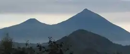 Mts. Gahinga (left) and Muhabura (right) | |
| Highest point | |
| Elevation | 4,127 m (13,540 ft) [1] |
| Prominence | 1,530 m (5,020 ft) [2] |
| Listing | Ultra |
| Coordinates | 01°23′00″S 29°40′00″E [1] |
| Naming | |
| English translation | The Guide |
| Language of name | Kinyarwanda |
| Geography | |
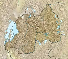 Mount Muhabura Location in Rwanda (on border with Uganda) | |
| Location | Rwanda–Uganda |
| Parent range | Virunga Mountains |
| Geology | |
| Mountain type | Stratovolcano |
| Last eruption | unknown[1] |
The name Muhabura means "The Guide" in the local language, Kinyarwanda.
It can be seen from many parts of Uganda and Rwanda because of its slope.

Volcanic rock from Muhabura containing crystals of augite
References
- "Mount Muhabura". Global Volcanism Program. Smithsonian Institution. Retrieved 2020-06-30.
- "Mount Muhabura". Peakbagger.com. Retrieved 2008-12-23.
This article is issued from Wikipedia. The text is licensed under Creative Commons - Attribution - Sharealike. Additional terms may apply for the media files.