Mount Pangrango
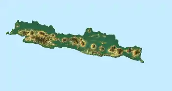
Mount Pangrango is a dormant stratovolcano located in the Sunda Arc of West Java, Indonesia.[1] The mountain formed by a subduction zone on the southern coast of Java facing the Indian Ocean. It is located about 80 km south of Jakarta, capital of Indonesia.
| Mount Pangrango | |
|---|---|
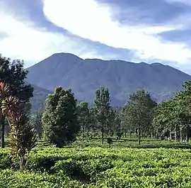 Mount Pangrango (highest peak on the left) seen from Puncak | |
| Highest point | |
| Elevation | 3,019 m (9,905 ft) [1] |
| Prominence | 2,426 m (7,959 ft) [2] |
| Coordinates | 6°46′38″S 106°58′52″E |
| Geography | |
| Geology | |
| Mountain type | Stratovolcano |
| Last eruption | Unknown |
| Climbing | |
| Easiest route | Cibodas |
It has the height of 3,019 m (9,905 ft).[2] Its peak is called Mandalawangi.[3] The mountain located northwest of Mount Gede in the vicinity of Gunung Gede Pangrango National Park.
Name
The name Pangrango is speculated to be originated from two ancient Sundanese words Pang and Rango which means "That which huffs and puffs" referring to the past volcanic activity of this mountain.[4]
Geography
The Mandalawangi peak of the mountain is a tripoint where the borders of Bogor, Cianjur and Sukabumi Regency meet. It is the second highest mountain in West Java after Mount Cereme. Mount Pangrango ranked 26th of the Ribus of Indonesia[2] with topographic prominence of 2,426 m (7,959 ft). The mountain is clearly seen from Bogor & Sukabumi, while it is slightly obscured by the neighboring Mount Gede if seen from Cianjur. On a very clear day it can be seen from Jakarta.
See also
References
- "Pangrango". Peakbagger.com.
- "The Ribus - Indonesia Peaks with 1000 meters of Prominence". Peakbagger.com. Retrieved 2015-11-17.
- Backshall, Stephen (May 26, 2003). The Rough Guide to Indonesia (2nd ed.). Rough Guides. p. 153. ISBN 978-1858289915.
- Gunung Pangrango | Gunung Bagging
| Wikimedia Commons has media related to Mount Pangrango. |
