Mount Rogers (British Columbia)
Mount Rogers, is a 3,169-metre (10,397-foot) massif located in Glacier National Park in the Selkirk Mountains of British Columbia, Canada. Mount Rogers is situated at the north end of the Hermit Range, and is the highest point of the range.[3] Its nearest higher peak is Mount Sir Donald, 12.57 km (7.81 mi) to the southeast.[3] The peak is prominently visible from eastbound Highway 1, the Trans-Canada Highway at Rogers Pass. The Rogers massif includes five individually-named summits: Rogers Peak, Grant Peak, Fleming Peak, Swiss Peak, and Truda Peaks.[4] Numerous glaciers radiate from all sides, including the Rogers Glacier, Swiss Glacier, Tupper Glacier, and Hermit Glacier.
| Mount Rogers | |
|---|---|
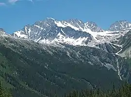 Mount Rogers as seen from Rogers Pass (Hermit Mountain in upper right) | |
| Highest point | |
| Elevation | 3,169 m (10,397 ft) [1] |
| Prominence | 1,439 m (4,721 ft) [1] |
| Parent peak | Iconoclast Mountain (3236 m)[1] |
| Coordinates | 51°21′14″N 117°32′14″W [2] |
| Geography | |
 Mount Rogers Location of Mount Rogers in British Columbia  Mount Rogers Mount Rogers (Canada) | |
| Location | Glacier National Park British Columbia, Canada |
| Parent range | Hermit Range, Selkirk Mountains[3] |
| Topo map | NTS 82N05 [2] |
| Climbing | |
| First ascent | 1896 Phillip S Abbott, George T Little, Charles S Thompson[1] |
| Easiest route | Scrambling YDS 4[1] |
History
Mount Rogers was named after Major A.B. Rogers, an American surveyor working for the Canadian Pacific Railway, and the discoverer of Rogers Pass.[1]
The first ascent of the mountain was made on July 31, 1896 by Phillip S. Abbott, George T. Little, and Charles S. Thompson.[1]
The mountain's name was made official in 1932 when approved by the Geographical Names Board of Canada.[2]
Climate
Based on the Köppen climate classification, Mount Rogers has a subarctic climate with cold, snowy winters, and mild summers.[5] Temperatures can drop below −20 °C with wind chill factors below −30 °C. Precipitation runoff from the mountain drains into tributaries of the Beaver River.
References
- "Mount Rogers (Rogers Peak)". Bivouac.com. Retrieved 2019-02-22.
- "Mount Rogers". Geographical Names Data Base. Natural Resources Canada. Retrieved 2019-02-22.
- "Mount Rogers, British Columbia". Peakbagger.com.
- Mount Rogers BC Geographical Names
- Peel, M. C.; Finlayson, B. L. & McMahon, T. A. (2007). "Updated world map of the Köppen−Geiger climate classification". Hydrol. Earth Syst. Sci. 11: 1633–1644. ISSN 1027-5606.
External links
- Weather forecast: Mount Rogers
- Mt. Rogers photo: Flickr