Mount Schank, South Australia
Mount Schank is a locality in the Australian state of South Australia located about 385 kilometres (239 miles) south-east of the state capital of Adelaide and 14 kilometres (8.7 miles) south of the municipal seat of Mount Gambier in the south-east of the state.[1][4]
| Mount Schank South Australia | |||||||||||||||
|---|---|---|---|---|---|---|---|---|---|---|---|---|---|---|---|
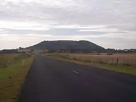 View of Mount Schank from the road to Port MacDonnell. | |||||||||||||||
 Mount Schank | |||||||||||||||
| Coordinates | 37.94°S 140.724°E[1] | ||||||||||||||
| Population | 249 (2016 census)[2] | ||||||||||||||
| Established | 31 October 1996[3] | ||||||||||||||
| Postcode(s) | 5291 [4] | ||||||||||||||
| Time zone | ACST (UTC+9:30) | ||||||||||||||
| • Summer (DST) | ACST (UTC+10:30) | ||||||||||||||
| Location |
| ||||||||||||||
| LGA(s) | District Council of Grant[1] | ||||||||||||||
| State electorate(s) | Mount Gambier [5] | ||||||||||||||
| Federal Division(s) | Barker[6] | ||||||||||||||
| |||||||||||||||
| |||||||||||||||
| Footnotes | Locations[4][1] Climate[7] Adjoining localities[1] | ||||||||||||||
Mount Schank originally began as a private sub-division of land within the cadastral unit of the Hundred of MacDonnell. Boundaries were created on 31 October 1996 for the “long established name.”[1][3]
Mount Schank consists of land adjoining both sides of the Riddoch Highway between Mount Gambier to the north and Port MacDonnell to the south. The locality includes a number of geological features consisting of the dormant[8] volcano, Mount Schank, which is located on the eastern side of the Riddoch Highway and a number of water-filled sinkholes such as the Little Blue Lake located on land to the west of the Riddoch Highway.[1] The majority land use within the locality is agriculture with an area located between the Riddoch highway and the western side of the dormant volcano is zoned for industrial purposes.[9][1]
The following places within Mount Schank are listed on the South Australian Heritage Register - Mount Salt Limestone Track[10] and Mount Schank state heritage area[11]
The 2016 Australian census which was conducted in August 2016 reports that Mount Schank had a population of 249 people.[2]
Mount Schank is located within the federal division of Barker, the state electoral district of Mount Gambier and the local government area of the District Council of Grant.[6][5][1]
References
- "Search result for "Mount Schank (Locality Bounded)" (Record no SA0015111) with the following layers selected - "Suburbs and Localities", "Place names (gazetteer)" "Local Government Areas" and "Development Plan Layers"". Property Location Browser. Government of South Australia. Archived from the original on 12 October 2016. Retrieved 17 August 2016.
- Australian Bureau of Statistics (27 June 2017). "Mount Schank". 2016 Census QuickStats. Retrieved 19 April 2018.

- Kentish, P.M. (31 October 1996), "GEOGRAPHICAL NAMES ACT 1991, Notice to Assign Boundaries and Names to Places" (PDF), The South Australian Government Gazette: 1517, retrieved 19 April 2018
- "Postcode for Mount Schank, South Australia". postcodes-australia.com. Retrieved 17 August 2016.
- "District of Mount Gambier Background Profile". Electoral Commission SA. Retrieved 28 March 2016.
- "Federal electoral division of Barker" (PDF). Australian Electoral Commission. Retrieved 28 March 2016.
- "Monthly climate statistics: Summary statistics Mount Gambier Aero (nearest weather station)". Commonwealth of Australia , Bureau of Meteorology. Retrieved 17 August 2016.
- "South Australia For Everyone: Mount Schank". www.australiaforeveryone.com.au. Retrieved 24 August 2018.
- "Development Plan, Grant Council, Consolidated – 11 February 2016" (PDF). [Government of South Australia. pp. 124, 127, 138, 199, 268–272 and 366. Retrieved 29 April 2016.
- "Mount Salt Limestone Track". South Australian Heritage Register. Department of Environment, Water and Natural Resources. Retrieved 18 August 2016.
- "Mount Schank state heritage area". South Australian Heritage Register. Department of Environment, Water and Natural Resources. Retrieved 18 August 2016.