Moyka
The Moyka (Russian: Мо́йка) is a small river in Russia that encircles the central portion of Saint Petersburg, effectively making it an island. The river, originally known as Mya, derives its name from the Ingrian word for "slush" or "mire". It is 5 kilometres (3 mi) long and 40 metres (130 ft) wide.

The river flows from the Fontanka near the Summer Garden past the Field of Mars, crosses Nevsky Prospect and the Kryukov Canal before entering the Neva river delta. It is also connected with the Neva by the Swan Canal and the Winter Canal.
In 1711 Peter the Great ordered the consolidation of the banks of the river. After the Kryukov Canal linked it with the Fontanka River four years later, the Moyka became so much clearer that its name was changed from Mya to Moyka, associated with the Russian verb "to wash".
In 1736 the first Moyka quay was constructed in wood. Four bridges originally spanned the river: the Blue, the Green, the Yellow, and the Red. The 99-metre (325 ft)-wide Blue Bridge, now hardly visible underneath Saint Isaac's Square, remains the widest bridge in the whole city.
Magnificent 18th-century edifices lining the Moyka quay include the Stroganov Palace, Razumovsky Palace, Yusupov Palace, New Holland Arch, Circular Market, St. Michael's Castle, and the last accommodation and museum of Alexander Pushkin.[1]
In 1798 work started to construct a stately embankment faced with red granite and adorned with ornate railings. After the completion of construction works in 1811, it was discovered that the water of the river became so muddy that its use for cooking has been officially forbidden ever since.
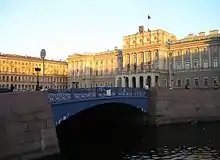
As of 2016 15 bridges cross the Moyka. Most of these have historical and artistic interest:
- Green Bridge (Zelyony most, 1806–08, by William Heste)
- Red Bridge (Krasny most, 1808–14, by William Heste)
- Potseluyev Bridge (Potseluyev most, 1808–16, by William Heste)
- Blue Bridge (Siny most, 1818, 1842–43, by William Heste and George Andreevich Adam)
- Postoffice Bridge (Pochtamtsky most, 1823–24, by Wilhelm von Traitteur)
- Big Stables Bridge (Bolshoy Konyushenny most, 1828, by George Adam)
- Tripartite Bridge (Malo-Konyushenny most, 1829–31, by George Adam and Wilhelm von Traitteur)
- First Engineer Bridge (Pervy Inzhenerny most, 1824–25, by George Adam and Wilhelm von Traitteur)
- First Sadovy Bridge (Pervy Sadovy most, 1835–36, by Pierre Dominique Bazaine)
- Yellow Bridge (Pevchesky most, 1839–40, by George Adam)
Water system of Ligovsky Canal | |||||||||||||||||||||||||||||||||||||||||||||||||||||||||||||||||||||||||||||||||||||||||||||||||||||||||||||||||||||||||||||||||||||||||||||||||||||||||||||||||||||||||||||||||||||||||||||||||||||||||||
|---|---|---|---|---|---|---|---|---|---|---|---|---|---|---|---|---|---|---|---|---|---|---|---|---|---|---|---|---|---|---|---|---|---|---|---|---|---|---|---|---|---|---|---|---|---|---|---|---|---|---|---|---|---|---|---|---|---|---|---|---|---|---|---|---|---|---|---|---|---|---|---|---|---|---|---|---|---|---|---|---|---|---|---|---|---|---|---|---|---|---|---|---|---|---|---|---|---|---|---|---|---|---|---|---|---|---|---|---|---|---|---|---|---|---|---|---|---|---|---|---|---|---|---|---|---|---|---|---|---|---|---|---|---|---|---|---|---|---|---|---|---|---|---|---|---|---|---|---|---|---|---|---|---|---|---|---|---|---|---|---|---|---|---|---|---|---|---|---|---|---|---|---|---|---|---|---|---|---|---|---|---|---|---|---|---|---|---|---|---|---|---|---|---|---|---|---|---|---|---|---|---|---|---|
| |||||||||||||||||||||||||||||||||||||||||||||||||||||||||||||||||||||||||||||||||||||||||||||||||||||||||||||||||||||||||||||||||||||||||||||||||||||||||||||||||||||||||||||||||||||||||||||||||||||||||||
References
- Isaeva, K., Aminova, D. (2019-09-11). "10 key places from St. Petersburg's literary map". Russia Beyond. Retrieved 2020-02-06.CS1 maint: multiple names: authors list (link)
 Media related to Moika River at Wikimedia Commons
- Канн П. Я. Прогулки по Петербургу: Вдоль Мойки, Фонтанки, Садовой. St. Petersburg, 1994.
Rivers and canals of Saint Petersburg | ||
|---|---|---|
|  | |