Muara, Brunei
Muara is a town in the north-easternmost part of Brunei-Muara District, Brunei. It is officially known in Malay as Pekan Muara (literally 'Muara Town') but is administered as a village-level subdivision under the mukim or subdistrict of Serasa.[1] Muara has no municipal body. It is home to Muara Port, the main and only deep-water port of the country.[2] The postcode for Muara is BT1128.[1][3]
Muara | |
|---|---|
Town | |
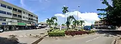 Old commercial area of Muara | |
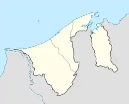 Location in Brunei | |
| Coordinates: 5°01′34″N 115°04′13″E | |
| Country | Brunei |
| District | Brunei-Muara |
| Mukim | Serasa |
| Postcode | BT1128 |
Location
Muara can be found in Mukim Serasa[5] and is located on the easternmost tip of West Brunei. It lends its name to the district which it is in, the Brunei-Muara district. To the north is the South China Sea, to the south is the Brunei Bay, and across the bay is Pulau Muara Besar. To the east, across a man-made channel, are the remains of Tanjung Pelumpong (Cape Pelumpong, now an island). The rest of the Brunei-Muara district is situated on the west side. Serasa lies to the south-west of Muara.
For the purpose of this article, the term 'Muara' refers to the area from Kampong Sabun to the channel at Tanjung Pelumpong north of Serasa.
History
Before the 1900s, the village of Muara was inhabited by a small group of Malay fishermen.[6]
Rapid development was seen in the area of Serai Pumping in 1883 to extract coal, which was used to fuel passing steamships; later, under the government of Sarawak, the area around the settlement was developed and was named Brooketon, after Charles Brooke, the White Rajah of Sarawak, in 1889.
The development of the Brooketon Colliery coal mine also led to transport and infrastructure development in Muara. A wooden railway was built to transport the coal to the deep-water anchorage at Muara, and wharves and jetties were built to allow steamships and barges to berth.[6] By 1911, more than 1,447 people lived in Muara and some 30 shops had opened in the town.[6] Brooketon was also where the first postage stamp in Brunei was issued.[7]
Although he only had economic privileges, Brooke became the de facto political ruler of the area. The coal mines employed hundreds of miners, which compelled Brooke to introduce a police force, a post office, and roads, effectively transforming Muara into an extraterritorial extension of Sarawak. It was not until 1921 that Muara was "returned" to Brunei.[6] The mine closed in 1924 because of heavy financial losses caused by the continuously decreasing price of coal during the world economic recession.[8]
The Japanese occupied Brunei during Second World War and attempted unsuccessfully to reopen the coal mine.[6] Brooketon was the landing location of the Australian forces as part of the Borneo Campaign (1945), at the end of the Second World War, which liberated Brunei from Japanese occupation.[9]
Under the rule of Sultan Omar Ali Saifuddin, the area was developed into a deepwater port to assist in the development of the country. Since 1973, Muara Port has undergone extensive improvements. These include extensions to the wharf, bringing its total length to 948 meters (including 250 meters dedicated container wharf and 87 metres aggregate wharf). The overall covered storage capacity is 16,950 square meters. The site also features long storage warehouses with a combined capacity of 16,630 square meters and open storage space of 5 hectares. Facilities for the dedicated container wharf cover an area of 92,034 square meters, including 8,034 square metres of covered areas.[10]
Oil and gas
Part of the deepwater port of Muara is occupied by two Royal Dutch Shell petroleum facilities.
Brunei Shell Marketing maintains a large presence in Muara through its Muara Terminal.[11] There are numerous bottled gas containers on the site and a number of tanks holding various products, including bitumen.
Brunei Shell Petroleum has a jetty along Muara Port to support their offshore operations in Brunei.[12] The jetty measures 120 metres by 48 metres and equipped with three loading facilities and 14 storage tanks.
Tourist attractions
The main tourist attraction of Muara is Muara beach (Pantai Muara in Malay), which stretches along the coast of the South China Sea.[13] The beach is about a mile long and consists of clear white sand. Amenities here include a picnic area, a children's playground, changing and toilet facilities, as well as weekend food and drink stalls.
Military
The Royal Brunei Navy of the Royal Brunei Armed Forces is based in the Muara Naval Base, which is located in the Tanjong Pelumpong area of Muara.[14] The Naval Base was expanded in 1997 to include facilities to support three offshore support vessels.[15]
Transportation
Road
Jalan Muara is Muara's main road. It originates in Mukim Berakas near the Brunei International Airport and terminates at the artificial channel at Tanjong Pelumpong. It connects Muara town to Bandar Seri Begawan.
Jalan Serasa and Jalan Persuahan branch off from Jalan Muara and connect Muara with Serasa. Tjey enables products manufactured in the Serasa Industrial Area to be transported to Muara Port for export.
The Muara-Tutong Highway starts at a roundabout on Jalan Muara between Kampong Sungai Kebun and Kampong Meragang. It connects Muara to Jerudong and Tutong.
Muara is served by the purple buses of the Eastern Line. Route numbers 33, 37, 38 and 39 connect Muara with Serasa and the rest of the country.
Rail
There are currently no railways or light rail facilities in Muara, as the line connecting Brooketon Colliery to what is now Muara Port is defunct.[6]
Ports
Muara Port was opened for commercial operations in February 1973 and was commissioned by the Ports Department on 1 May 1974. The Ports Department took over the management and operations of all ports on 1 January 1986, forming the Royal Customs and Excise Department.[16]
The Muara Container Terminal was operated by the PSA International until 1 April 2007, when it was turned to the Brunei Government. It features one container berth with a quay length of 250m and a max draft of 12.5m.[17]
There is an existing plan by the Brunei Economic Development Board to further develop the port by further dredging the Muara Cut, constructing additional port facilities on Pulau Muara Besar, and linking the latter to the mainland with a bridge.[18]
From May 2009, International Container Terminal Service Inc (ICTSI), based in Manila, Philippines, set up a subsidiary, New Muara Container Terminal Service Sdm Bhd (NMCTS), to operate the Muara Container Terminal. August 2009, Chinese destroyer Guangzhou made a goodwill visit to Muara Port from Manado.[19]
In early 2017, Muara Port Company Sdn Bhd, a joint-venture company of Darussalam Assets Sdn Bhd and Beibu Gulf Holding(Hong Kong) Co.,Ltd., took over the operation of the terminal.
The port is part of the Maritime Silk Road that runs from the Chinese coast to Singapore and the southern tip of India, west from India to Mombasa, Kenya, through the Red Sea via the Suez Canal to the Mediterranean, and then via Athens to the Upper Adriatic hub of Trieste, Italy, with its rail connections to Central Europe and the North Sea.[20][21][22]
Air
There are no airports in Muara. Commercial travellers would have to travel to either Bandar Seri Begawan or Labuan (from Serasa) to catch a commercial flight.
Image gallery
- Muara Gallery
 Muara Port
2.JPG.webp) A berth at Muara Port
A berth at Muara Port.jpg.webp) Muara Beach
Muara Beach Recreational park at Muara Beach
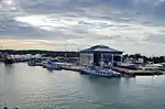 Muara Naval Base
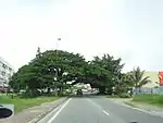 A road in Muara
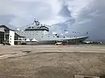 People's Liberation Army Navy ship Qi Ji Guang's (Hull-83) goodwill visit to Muara Port on September 29, 2019.
References
- "Brunei Postal Services - postcodes". post.gov.bn. Retrieved 28 February 2018.
- "Brunei-Muara District" (PDF). www.information.gov.bn. p. 17. Retrieved 28 February 2018.
- "Pekan Muara, Serasa, Brunei Muara: BT1128 | Brunei Postcode". brn.postcodebase.com. Retrieved 28 February 2018.
- Toponomy - the study of place names Brunei Resources 28 November 2006 - retrieved 19 April 2007
- Poskod bagi Daerah Brunei Muara Archived 12 July 2007 at the Wayback Machine Brunei-Muara Postcodes - retrieved 19 April 2007
- Before the Oil, it was Coal Brunei Times 14 April 2007
- History of Brunei Stamps Archived August 29, 2012, at WebCite by the Brunei Postal Service Department - retrieved 19 September 2019
- Brooketon Colliery Archived 28 September 2007 at the Wayback Machine from The Geology and Hydrocarbon Resources of Negara Brunei Darussalam retrieved 16 April 2007
- Negara Brunei Darussalam Archived 8 January 2007 at the Wayback Machine by A Allaert
- 8th National Development Plan Archived 5 April 2007 at the Wayback Machine Government of Brunei Darussalam - retrieved 19 April 2007
- BSM presents safety awards to Belait Shipping Company Archived 27 September 2007 at the Wayback Machine Brunei Government - retrieved 19 April 2007
- New Muara Supply Base Jetty Boost for BSP’s Operations 13 March 2007 - retrieved 19 March 2007
- Tourism Brunei Beaches Archived 7 March 2007 at the Wayback Machine - retrieved 19 April 2007
- Introduction Royal Brunei Navy - retrieved 19 April 2007
- "page 15 GHD Annual Review 2002/2003" (PDF). Archived from the original (PDF) on 9 August 2008. Retrieved 19 April 2007.
- Ports Department Archived 28 September 2007 at the Wayback Machine - retrieved 19 April 2007
- Muara Port Returns To Govt In April Archived 6 February 2007 at the Wayback Machine BruDirect 30 February 2007 - retrieved 19 April 2007
- Pulau Muara Besar Port Project, BEDB Archived 24 August 2007 at the Wayback Machine - retrieved 28 May 2007
- "海军"广州"舰结束访问文莱、印尼抵三亚(图)——中新网". www.chinanews.com. Retrieved 14 December 2020.
- Brunei bets on China's Silk Road in hard times
- 21st Century Maritime Silk Road matches very well with Brunei
- The Geopolitical Evolution of Malaysia-Pakistan and Turkey on the 21st Century Maritime Silk Road Route