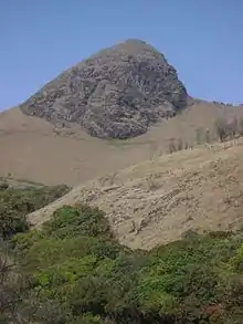
Mukurthi
Mukurthi Peak is the one of the highest peaks in the Western Ghats of Tamil Nadu, India. It stand at an altitude of 2,554m (8,379ft). Mukurthi Peak is the fifth highest peak in South India.[1] It is situated in the border of Udagamandalam taluk, Nilgiris, Tamil Nadu, and Nilambur taluk, Malappuram, Kerala. Western slope of the hill is kerala tamil nadu border ,with many cliffs from 2500m end upto to 500m, part of mukkuruthi-within malappuram district is the third highest point in kerala,after anaimudi (2696m)-idukki and meeshapulimala (2651m)-idukki, the place can be accessible only through nilgiri district,and no direct access from malappuram. Mukurthi peak resembles to "Pointed Nose".
It is a part of Mukurthi National Park (Nilgiri Tahr National Park), Nilgiri Biosphere Reserve. Mukurthi hill is covered with shola forest including pine, grasslands and shrublands. It is a favorable place for Asian elephant, Tiger and rare endemic to Nilgiri Tahr. Mukurthi National Park (peak) sandwiched between Mudumalai National Park and Silent Valley National Park. Ooty is the nearest town (30 km away).
It is one of the best trekking place and tourist spot in Ooty. Pichalbetta (2,544m) and Nilgiri hill are the prominent peaks adjacent to these area. Mukurthi dam (lake) is also nearby.
References
- "Top 10 Highest Peaks In South India - Highest Peaks Of South India". 20 August 2020. Retrieved 23 August 2020.