Nadiad
Nadiad is a city in the state of Gujarat, India and the administrative centre of the Kheda district. The city is managed by the Nadiad Municipal Corporation. It is known for the Santram Mandir, the Mai Mandir,[1] the historic Swaminarayan temple built in 1824,[2] and the Anand and Hari Om Ashram.[3] Nadiad is located 90 kilometres (56 mi) away from Gandhinagar, the capital of Gujarat. It has a major railway junction and is a main station on the Ahmedabad-Mumbai route. It is the birth place of Sardar Vallabhbhai Patel, the first Deputy Prime Minister of India.
Nadiad | |
|---|---|
City | |
 | |
 Nadiad  Nadiad | |
| Coordinates: 22.69°N 72.86°E | |
| Country | India |
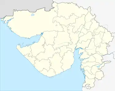
| State | Gujarat |
| District | Kheda |
| Government | |
| • Type | Nadiad Municipal Corporation |
| Area | |
| • City | 45.16 km2 (17.44 sq mi) |
| • Metro | 60.36 km2 (23.31 sq mi) |
| Area rank | 8th in Gujarat |
| Elevation | 35 m (115 ft) |
| Population (2011) | |
| • City | 225,071 (2,011) |
| • Rank | 13th in Gujarat |
| • Density | 4,983.85/km2 (12,908.1/sq mi) |
| • Metro | 330,400 (2,021 expected) |
| Demonym(s) | Nadiadi, Charotari |
| Languages | |
| • Official | Gujarati, Hindi, English |
| Time zone | UTC+5:30 (IST) |
| PIN | 387 001,387 002,387 003 |
| Telephone code | 0268 |
| Vehicle registration | GJ-7 |
| Website | nadiadmunicipality |
History
The city of Nadiad was settled by rope dancers, it has historical names as Natapadra, Natpur. It is also referred to as Nandgam. 'Sakshar Bhumi' (The land of educated).[4] The city was formerly ruled by Muslim rulers and later by the Gaekwad of Baroda.[5]
Economy
Nadiad has Good Economy due to Industrial Zone.Nadiad has Major Industrial Zone.Nadiad has Major GIDC Area Including kamla and Manjipura.
Geography
Nadiad is located at Latitude: 22°41′37″ N and Longitude: 72°51′41″ E. It has an average elevation of 41 meters (134 feet).[6] it has area of 45.16 square kilometers city area And Metropolitan Area of Nadiad is 71.2 square kilometers. It is the 8th-largest city in Gujarat state. It is between two major cities Ahmedabad and Vadodara.
Climate
Nadiad usually has mild winters and very hot summers, with an average of from 32 °C (90 °F) to 46 °C (115 °F), and an average rainfall from 70 centimetres (28 in) to 120 centimetres (47 in).
Demographics
As of 2011 India census,[7] Nadiad had a population of 225,071. Males constitute 52% of the population and females 48%. Nadiad has an average literacy rate of 95%, higher than the national average of 59.5%: male literacy is 96%, and female literacy is 94%. In Nadiad, 9% of the population is under 6 years of age.
Attractions
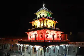
Santram Mandir is located in the center of the city. It is known for its charity work. This old temple is full with people on the day of full moon.[2] Marida Darwaja and Amdavadi Darwaja are also nearby.
Transport
Nadiad is Well Connected With Railway and Road Transport. Nadiad Junction railway station is Major Railway Station in Kheda District and Indian Railways's "A" Category Railway Station Located in Ahmedabad-Mumbai Main Line. Nadiad has two extra lines. One goes to Modasa and other one goes to Petlad. Nadiad Junction railway station has four platforms. Indian Railway is going to extend Modasa Line to Shamlaji. Nadiad has a major bus stand. Nadiad is Zonal Division in Charotar Region. Anand, Mahemdavad, Kapadvanj, Dakor, Mahudha, Borsad, Khambhat bus depot's Are Under Nadiad Division. Nadiad Division is Called by Amul. Nadiad is well connected to Ahmedabad, Vadodara, Gandhinagar, Surat, Rajkot by bus. Other interstate services are operated by Nadiad Division from Nadiad. Nearest airport is Sardar Vallabhbhai Patel International Airport located in Ahmedabad and it is 65 km away from Nadiad.
Notable People
- Mansukhram Tripathi (1840 – 1907), Gujarati writer
- Govardhanram Tripathi (1855 – 1907), Indian novelist, author of the epic Gujarati novel Saraswatichandra
- Balashankar Kantharia (1858 – 1898), Gujarati poet
- Manilal Dwivedi (1858 – 1898), Gujarati writer
- Vallabhbhai Patel (1875 – 1950), Indian politician
- Indulal Yagnik (1892 – 1972), Indian freedom fighter and writer, led Mahagujarat movement demanding separate statehood to Gujarat
- Bakul Tripathi (1928 – 2006), Indian humorist
- Dinsha Patel (born 1937), Indian politician
- Amar Gupta (born 1953), Indian computer scientist
- Praful Patel (born 1957), Indian politician and businessman
- Akshar Patel (born 1994), Indian cricketer
- Babubhai Patel, Indian politician
- Vishvesh Parmar, Indian singer
- Abdul Karim Nadiadwala, Indian film producer, grandfather of Sajid Nadiadwala
Education
Some of the educational institutes located in Nadiad are:
References
- Shri Mai Mandir. maimandir.org.
- Temples in Nadiad. nadiad.in.
- Hari Om Mota. hariommota.org.
- usa. "History of Nadiad – usa". Retrieved 17 January 2020.
- "About Nadiad City".
- "Geographic coordinates of Nadiad. Latitude, longitude, and elevation above sea level of Nadiad, India". dateandtime.info. Retrieved 17 January 2020.
- "Nadiad City Population Census 2011 | Gujarat". www.census2011.co.in. Retrieved 11 July 2017.
External links
| Wikimedia Commons has media related to Nadiad. |