Nairobi River
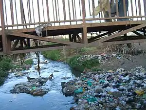
Nairobi River is a river flowing through the Kenyan capital Nairobi. It is the main river of the Nairobi river basin, a complex of several parallel streams flowing eastwards. All of the Nairobi basin rivers join east of Nairobi and meet the Athi River, eventually flowing to the Indian ocean. These rivers are mostly narrow and highly polluted,[1] though recent efforts have seen fruitful gains in cleaning up the river.[2]

The main stream, Nairobi River, bounds the northern city centre, where it is partly canalized.
Tributaries
Nairobi Rivers' source is at Ondiri swamp in Kikuyu.[3]
Nairobi River has several tributaries, including (in descending order from north to south):
- Ruiru River
- Kamiti River
- Kasarani River (aka Gathara-ini)
- Ruaraka (aka Rui Ruaka)
- Karura River
- Gitathuru River (aka Getathuru)
- Mathare River
- Nairobi River (the main channel)
- Kirichwa
- Motoine-Ngong River
Motoine River flows to the Nairobi Dam, an artificial lake meant to provide drinkable water for residents of Nairobi.
Further onwards the stream continues as Ngong River.
Gathara-ini Stream [4] originates in marshes in the lower reaches of Aberdare mountains and flows through human settled areas. The stream experiences different impacts originating from anthropogenic sources along the channels and in the catchment. In the upper sections of Kiambaa and Kanunga areas, the stream passes through swampy and marshy areas, with subsistence agriculture and human settlement being the main types of land use. In the midsections of Kiambu, extensive coffee estates and intensive mixed farming are the major forms of land use.
In the lower sections of Githurai and Zimmerman, the stream is characterized by coffee farming, intensive mixed farming and some industries such as Kamiti Tannery Factory. The lower stream waters are brackish and characterized by a foul smell. Riverine subsistence agriculture of arrowroots and kales were common throughout the studied area. Efforts to conserve and preserve this river are yet to be initiated.
Nairobi's rivers suffer from contaminations by agriculture, slums and industrial areas.[5][6] During rainy seasons the discharge tends to multiply, causing floods on low-lying riverbanks.
There is a second river called Nairobi in Kenya. It starts on Mount Kenya and is a tributary of the Sagana and then the Tana, the longest river in Kenya.[7]
See also
References
- Ndiritu, G. G., N. N. Gichuki, P. Kaur and L. Triest. 2003. Characterization of environmental gradients using physico-chemical measurements and diatom densities in Nairobi River, Kenya. Aquatic Ecosystem Health & Management, 6 (3): 343-354.
- http://www.unep.org/urban_environment/PDFs/ISWMLaunch_NairobiRiverBasin.pdf
- Obura, Fredrick. "Increased human activities threaten source of Nairobi River - Smart Harvest". www.farmers.co.ke. Retrieved 2020-05-29.
- Ndaruga, A. M., G. G. Ndiritu, N. N. Gichuki and W. N. Wamicha.N. 2004. Impact of water quality changes on riverine macroinvertebrate assemblages along a tropical stream, Kenya. African Journal of Ecology 42: 208-216
- Biosafety News, October/November 2002
- Ndiritu, G. G., N. N. Gichuki and L. Triest. 2006. Distribution of epilithic diatoms in response to environmental conditions in an urban tropical stream, Central Kenya. Biodiversity and conservation 15:3267-3293
- Rough Guide Map Kenya (Map) (9 ed.). 1:900,000. Rough Guide Map. Cartography by World Mapping Project. Rough Guide. 2006. ISBN 1-84353-359-6.
External links
- River basin Map
- UNEP: Nairobi River Basin Programme
- Wikimapia Nairobi Dam
