Nan, Thailand
Nan (Thai: น่าน, pronounced [nâːn]) is a town in northern Thailand. It is 688 km (428 mi) north of Bangkok. It is in the centre of Nan Province which bears its name, and of which it is the former administrative capital.[3] It covers tambon Nai Wiang and parts of tambon Pha Sing of Mueang Nan District, an area of 7.60 km2 (2.93 sq mi) divided into 30 chumchon. In 2010 it had a population of 21,333 spread along the Nan River's right bank. Nan is a small city, primarily devoted to commercial, administrative, educational, and hospital activities. The old heart of the city, where Wat Phumin, the national museum and other tourist attractions are found, is being restored.
Nan
น่าน | |
|---|---|
| เทศบาลเมืองน่าน | |
 City pillar shrine, Nan, Wat Ming Mueang | |
 Nan | |
| Coordinates: 18°47′N 100°47′E | |
| Country | Thailand |
| Province | Nan |
| Elevation | 211 m (692 ft) |
| Population (2017)[2] | |
| • Total | 20,012 |
| • Density | 2,633.16/km2 (6,819.9/sq mi) |
| Time zone | UTC+7 (ICT) |
History
Nan for centuries was a separate, autonomous kingdom with few relationships with the outside world. There is evidence of prehistoric habitation, but it wasn't until several small mueang united to form Nanthaburi on the Nan River in the mid-14th century, contemporaneously with the creation of Luang Prabang and the Lan Xang (Million Elephants) kingdom in Laos, that the city became notable. Associated with the Sukhothai Kingdom, the mueang took the title Wara Nakhon and played a significant part in the development of early Thai nationalism.
By the end of the 14th century Nan was one of the nine northern Thai-Lao principalities that formed Lan Na Thai (now Lanna). The city-state flourished throughout the 15th century under the name Chiang Klang ('middle city'), a reference to its position roughly midway between Chiang Mai ('new city') and Chiang Thong ('golden city'), today's Luang Prabang).
The Burmese took control of the kingdom in 1558 and deported many of the inhabitants to Burma as slaves; the city was deserted until northern Thailand was retaken from the Burmese in 1786. The local dynasty then regained local sovereignty and it remained semi-autonomous until 1931 when Nan finally accepted full Bangkok dominion. Part of its territory had been annexed to Laos by the French in the late-19th century.
Parts of the old city wall and several early wats dating from the Lanna period can be seen in contemporary Nan. The city's wats are distinctive; some temple structures show Lanna influence, while others belong to the Thai Lue legacy brought from Xishuangbanna in China, where the Thai Lue people originated.
Climate
| Climate data for Nan (1981–2010) | |||||||||||||
|---|---|---|---|---|---|---|---|---|---|---|---|---|---|
| Month | Jan | Feb | Mar | Apr | May | Jun | Jul | Aug | Sep | Oct | Nov | Dec | Year |
| Record high °C (°F) | 36.8 (98.2) |
38.8 (101.8) |
41.8 (107.2) |
43.0 (109.4) |
41.9 (107.4) |
40.3 (104.5) |
38.0 (100.4) |
38.4 (101.1) |
36.3 (97.3) |
36.6 (97.9) |
36.7 (98.1) |
35.3 (95.5) |
43.0 (109.4) |
| Average high °C (°F) | 30.8 (87.4) |
33.4 (92.1) |
36.2 (97.2) |
37.0 (98.6) |
35.0 (95.0) |
33.5 (92.3) |
32.4 (90.3) |
32.2 (90.0) |
32.7 (90.9) |
32.5 (90.5) |
31.2 (88.2) |
29.6 (85.3) |
33.0 (91.4) |
| Daily mean °C (°F) | 21.4 (70.5) |
23.6 (74.5) |
26.8 (80.2) |
29.0 (84.2) |
28.6 (83.5) |
28.3 (82.9) |
27.7 (81.9) |
27.3 (81.1) |
27.2 (81.0) |
26.4 (79.5) |
23.9 (75.0) |
21.0 (69.8) |
25.9 (78.6) |
| Average low °C (°F) | 14.2 (57.6) |
15.6 (60.1) |
18.9 (66.0) |
22.3 (72.1) |
23.5 (74.3) |
24.0 (75.2) |
23.8 (74.8) |
23.6 (74.5) |
23.3 (73.9) |
21.9 (71.4) |
18.5 (65.3) |
14.5 (58.1) |
20.3 (68.5) |
| Record low °C (°F) | 5.8 (42.4) |
8.0 (46.4) |
9.1 (48.4) |
17.4 (63.3) |
18.5 (65.3) |
20.1 (68.2) |
19.6 (67.3) |
19.4 (66.9) |
19.4 (66.9) |
13.4 (56.1) |
6.2 (43.2) |
2.7 (36.9) |
2.7 (36.9) |
| Average rainfall mm (inches) | 4.4 (0.17) |
11.9 (0.47) |
32.7 (1.29) |
99.6 (3.92) |
177.3 (6.98) |
133.8 (5.27) |
200.7 (7.90) |
273.2 (10.76) |
203.5 (8.01) |
70.3 (2.77) |
18.1 (0.71) |
8.6 (0.34) |
1,234.1 (48.59) |
| Average rainy days | 1.3 | 1.6 | 4.0 | 8.5 | 15.9 | 15.8 | 18.7 | 22.2 | 16.8 | 10.0 | 3.2 | 1.0 | 119.0 |
| Average relative humidity (%) | 76 | 70 | 65 | 68 | 76 | 79 | 82 | 84 | 84 | 82 | 80 | 78 | 77 |
| Mean monthly sunshine hours | 272.8 | 257.1 | 294.5 | 243.0 | 198.4 | 156.0 | 120.9 | 117.8 | 144.0 | 201.5 | 216.0 | 254.2 | 2,476.2 |
| Mean daily sunshine hours | 8.8 | 9.1 | 9.5 | 8.1 | 6.4 | 5.2 | 3.9 | 3.8 | 4.8 | 6.5 | 7.2 | 8.2 | 6.8 |
| Source 1: Thai Meteorological Department[4] | |||||||||||||
| Source 2: Office of Water Management and Hydrology, Royal Irrigation Department (sun and humidity)[5] | |||||||||||||
Gallery
 The standing Buddha of Wat Phra That Khao Noi overlooks Nan
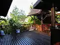 Chao Fongkham House balcony
 Murals of Wat Phumin
 Wat Phra That Chang Kham
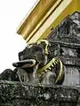 Gilded elephant heads of the chedi, Wat Phra That Chang Kham
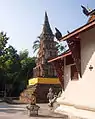 Hariphunchai-style chedi, Wat Phaya Wat
References
- "Nan Airport (NNT), Nan, Thailand". LatLong.net. Retrieved 2018-12-27.
- รายงานสถิติจำนวนประชากรและบ้าน ประจำปี พ.ศ. 2560 ท้องถิ่นเทศบาลเมืองน่าน ระบบสถิติทางการทะเบียน กรมการปกครอง
- "Nan". Tourism Authority of Thailand (TAT). Retrieved 18 May 2015.
- "Climatological Data for the Period 1981–2010". Thai Meteorological Department. pp. 3–4. Retrieved 31 July 2016.
- "ปริมาณการใช้น้ำของพืชอ้างอิงโดยวิธีของ Penman Monteith (Reference Crop Evapotranspiration by Penman Monteith)" (PDF) (in Thai). Office of Water Management and Hydrology, Royal Irrigation Department. p. 22. Retrieved 31 July 2016.
Further reading
- Ratchasomphan (Sænluang) (1994). David K. Wyatt (ed.). The Nan Chronicle. Translated by David K. Wyatt. SEAP Publications. ISBN 0-87727-715-X.
External links
 Nan travel guide from Wikivoyage
- David K. Wyatt. "THE CHRONOLOGY OF NAN HISTORY, A.D.1320-1598" (PDF). siamese-heritage.org. Retrieved 9 July 2017.
- Tourism Authority of Thailand: Nan
- Oriental Architecture profile - photos of 12 sites in Nan with GPS calibrated map
| Authority control |
|---|