Northern Thailand
Northern Thailand is geographically characterised by several mountain ranges, which continue from the Shan Hills in bordering Myanmar to Laos, and the river valleys which cut through them. Though like most of Thailand, it has a tropical savanna climate, its relatively high elevation and latitude contribute to more pronounced seasonal temperature variation, with cooler winters than the other regions. Historically it is related to the Lanna Kingdom and its culture.
Northern Region
ภาคเหนือ | |
|---|---|
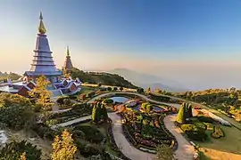   .jpg.webp)  From upper-left to lower-right: Doi Inthanon, Doi Pha Hom Pok, Wat Phra That Doi Suthep, Fourth Thai–Lao Friendship Bridge and Phu Chi Fa | |
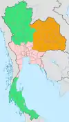
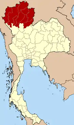 Northern Region in Thailand | |
| Largest city | Chiang Mai |
| Provinces | |
| Area | |
| • Total | 93,691 km2 (36,174 sq mi) |
| Population (2018)[2] | |
| • Total | 6,341,973 |
| • Density | 77/km2 (200/sq mi) |
| Demonym(s) | Khon Muang |
| Language | Northern Thai • others |
Geography
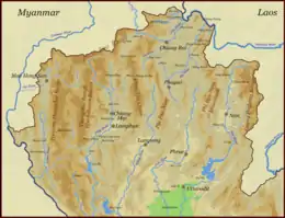
North Thailand is bound by the Salween River in the west and the Mekong in the east. The basins of rivers Ping, Wang, Yom, and Nan, all tributaries of the Chao Phraya River, in the central part run from north to south and are mostly very wide. The basins cut across the mountains of two great ranges, the Thanon Range in the western part and the Phi Pan Nam in the eastern. Their elevations are generally moderate, a little above 2,000 metres (6,562 ft) for the highest summits. Although formerly forested, many of these mountains are now denuded.[3]
Parallel mountain ranges extend from the Daen Lao Range (ทิวเขาแดนลาว), in the southern region of the Shan Hills, in a north-south direction, the Dawna Range (ทิวเขาดอยมอนกุจู) forming the western border of Thailand between Mae Hong Son and the Salween River.[4] To the east the Thanon Thong Chai Range (เทือกเขาถนนธงชัย), the Khun Tan Range (ทิวเขาขุนตาน), the Phi Pan Nam Range (ทิวเขาผีปันน้ำ), as well as the western part of the Luang Prabang Range (ทิวเขาหลวงพระบาง), form the natural region of the Thai highlands together with the former.[5]
These high mountains are incised by steep river valleys and upland areas that border the central plain. A series of rivers, including the Nan, Ping, Wang, Yom, and Nan, flow southwards through mountain valleys and join to form the Chao Phraya in Nakhon Sawan Province in the central region. Sirikit Dam is on the Nan River in Uttaradit Province. The northeastern part is drained by rivers flowing into the Mekong basin, like the Kok and Ing.
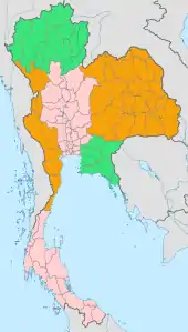
The four-region system includes the northern parts of the central plain as well as some mountainous areas bordering the western and the northeastern limits.
National parks
Within the northern region there are some sixty national parks. Chiang Mai Province has nine national parks of which Doi Inthanon National Park with the country's highest mountain and Op Luang National Park have a scenic river canyon, waterfalls, and caves. Doi Khun Tan National Park, which is located midway between the two provincial capitals of province Lampang and Lamphun, is best known for Thailand's longest railroad tunnel, which is 1,352 metres (4,436 ft) long. Doi Phu Kha National Park in province Nan is northern Thailand's largest national park.
Regional classification of northern Thailand
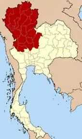
The northern region, as defined by the National Geographical Committee in 1978, consists of nine provinces. Geographically the division, in conformance with the six-region system, includes most of the mountainous natural region of the Thai highlands.
In the four-region classification system, northern Thailand gains the eight upper-central-region provinces: Kamphaeng Phet, Nakhon Sawan, Phetchabun, Phichit, Phitsanulok, Sukhothai, Uthai Thani and Tak, bringing the total to 17 provinces.
In 2019 it is common to subdivide the northern region into: nine provinces of the upper northern region and eight provinces of the lower northern region. All websites of these eight provinces state: "located in the lower northern region".
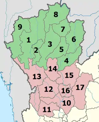
| Flag | Seal | Province | Capital | DOPA | Population | Area (km2) | Density | ISO | |
|---|---|---|---|---|---|---|---|---|---|
 |
 |
1 | Chiang Mai | Chiang Mai | 14 | 1,779,254 | 20,107.0 | 88 | TH-50 |
 |
 |
2 | Lamphun | Lamphun | 54 | 405,075 | 4,505.9 | 90 | TH-51 |
 |
 |
3 | Lampang | Lampang | 53 | 738,316 | 12,534.0 | 59 | TH-52 |
 |
 |
4 | Uttaradit | Uttaradit | 75 | 453,103 | 7,838.6 | 58 | TH-53 |
 |
 |
5 | Phrae | Phrae | 41 | 441,726 | 6,538.6 | 68 | TH-54 |
 |
 |
6 | Nan | Nan | 26 | 478,227 | 11,472.1 | 42 | TH-55 |
 |
 |
7 | Phayao | Phayao | 34 | 472,356 | 6,335.1 | 75 | TH-56 |
 |
 |
8 | Chiang Rai | Chiang Rai | 13 | 1,298,304 | 11,678.4 | 111 | TH-57 |
 |
 |
9 | Mae Hong Son | Mae Hong Son | 45 | 284,138 | 14,542.0 | 20 | TH-58 |
 |
 |
10 | Nakhon Sawan | Nakhon Sawan | 23 | 1,059,887 | 9,597.7 | 110 | TH-60 |
 |
 |
11 | Uthai Thani | Uthai Thani | 76 | 328,618 | 6,730.3 | 49 | TH-61 |
 |
 |
12 | Kamphaeng Phet | Kamphaeng Phet | 5 | 725,867 | 8,607.3 | 85 | TH-62 |
 |
 |
13 | Tak | Tak | 17 | 665,620 | 16,406.6 | 41 | TH-63 |
 |
14 | Sukhothai | Sukhothai | 66 | 595,072 | 6,596.1 | 90 | TH-64 | |
 |
15 | Phitsanulok | Phitsanulok | 38 | 865,247 | 10,815.9 | 80 | TH-65 | |
 |
 |
16 | Phichit | Phichit | 37 | 536,311 | 4,531.0 | 118 | TH-66 |
 |
 |
17 | Phetchabun | Phetchabun | 40 | 992,451 | 12,668.4 | 78 | TH-67 |
Notes
- Populations as of 31 December 2019.[6]
- There was no population survey in 2020 due to Covid-19.
- Reports (data) from Thai government are "not copyrightable" (Public Domain), Copyright Act 2537 (1994), section 7.
- Ethnic communities in northern Thailand
 Karen woman
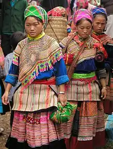 Hmong women
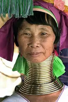
.jpg.webp) River woman
River woman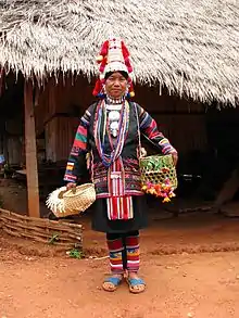 Akha woman
References
- Advancing Human Development through the ASEAN Community, Thailand Human Development Report 2014, table 0:Basic Data (PDF) (Report). United Nations Development Programme (UNDP) Thailand. pp. 134–135. ISBN 978-974-680-368-7. Retrieved 17 January 2016, Data has been supplied by Land Development Department, Ministry of Agriculture and Cooperatives, at Wayback Machine.
- "รายงานสถิติจำนวนประชากรและบ้านประจำปี พ.ศ.2561" [Statistics, population and house statistics for the year 2018]. Registration Office Department of the Interior, Ministry of the Interior (in Thai). 31 December 2018. Retrieved 20 June 2019.
- Forest data: Thailand Deforestation Rates
- Northern Thailand Archived 2012-01-28 at the Wayback Machine
- ดร.กระมล ทองธรรมชาติ และคณะ, สังคมศึกษา ศาสนาและวัฒนธรรม ม.1, สำนักพิมพ์ อักษรเจริญทัศน์ อจท. จำกัด, 2548, หน้า 24-25
- "ข้อมูลประชากรปี 2562".
External links
| Wikimedia Commons has media related to Northern Thailand. |
 North (Thailand) travel guide from Wikivoyage
 | Four-region division system |
|  |
|---|---|---|---|
| Six-region division system |
| ||