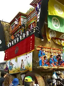
Nanao, Ishikawa
Nanao (七尾市, Nanao-shi) is a city located in Ishikawa Prefecture, Japan. As of 31 January 2018, the city had an estimated population of 53,819 in 22212 households, and a population density of 170 persons per km².[1] The total area of the city was 318.32 square kilometres (122.90 sq mi). Nanao is the fifth largest city by population in Ishikawa, behind Kanazawa, Hakusan, Komatsu, and Kaga.
Nanao
七尾市 | |
|---|---|
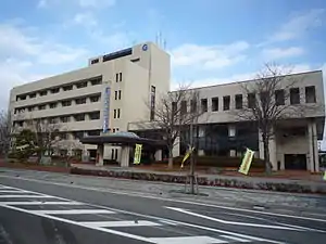 Nanao City Hall | |
 Flag  Seal | |
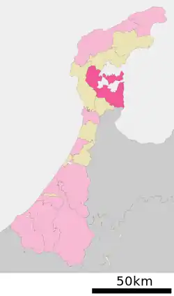 Location of Nanao in Ishikawa Prefecture | |
 Nanao | |
| Coordinates: 37°2′35.3″N 136°58′2.8″E | |
| Country | Japan |
| Region | Chūbu (Hokuriku) |
| Prefecture | Ishikawa Prefecture |
| Government | |
| • - Mayor | Fushima Toyokazu |
| Area | |
| • Total | 318.32 km2 (122.90 sq mi) |
| Population (January 31, 2018) | |
| • Total | 53,819 |
| • Density | 170/km2 (440/sq mi) |
| Time zone | UTC+9 (Japan Standard Time) |
| City symbols | |
| -Tree | Pine |
| -Flower | Azalea |
| -Bird | Common gull |
| Phone number | 0767-53-1111 |
| Address | 1-25 Sodegaemachi, Nanao-shi, Ishikawa-ken 926-8611 |
| Website | www |

Geography
Nanao occupies the southeastern coast of Noto Peninsula and is bordered by the Sea of Japan on the east and north, and Toyama Prefecture to the south. Parts of the city are within the borders of the Noto Hantō Quasi-National Park. The name "Nanao" (七尾) literally means "Seven Tails" and is said to be named for the seven mountain ridges (or "tails") surrounding Nanao that are visible when viewed from Joyama (七尾城山), site of the city's historical castle ruins. These ridges are called Kikuo (菊尾, "Chrysanthemum Tail"), Kameo (亀尾, "Turtle Tail"), Matsuo (松尾, "Pine Tail"), Torano'o (虎尾, "Tiger Tail"), Takeo (竹尾, "Bamboo Tail"), Umeo (梅尾, "Plum Tail"), and Tatsuo (龍尾, "Dragon Tail").
Demographics
Per Japanese census data,[2] the population of Nanao has declined over the past 40 years.
| Census Year | Population |
|---|---|
| 1970 | 68,303 |
| 1980 | 69,945 |
| 1990 | 68,692 |
| 2000 | 63,963 |
| 2010 | 57,900 |
Climate
Nanao has a humid continental climate (Köppen Cfa) characterized by mild summers and cold winters with heavy snowfall. The average annual temperature in Nanao is 13.7 °C. The average annual rainfall is 2392 mm with September as the wettest month. The temperatures are highest on average in August, at around 26.0 °C, and lowest in January, at around 2.9 °C.[3]
| Climate data for Nanao (1981–2010) | |||||||||||||
|---|---|---|---|---|---|---|---|---|---|---|---|---|---|
| Month | Jan | Feb | Mar | Apr | May | Jun | Jul | Aug | Sep | Oct | Nov | Dec | Year |
| Average high °C (°F) | 5.8 (42.4) |
6.5 (43.7) |
10.2 (50.4) |
16.3 (61.3) |
21.1 (70.0) |
24.7 (76.5) |
28.4 (83.1) |
30.6 (87.1) |
26.1 (79.0) |
20.6 (69.1) |
14.7 (58.5) |
9.2 (48.6) |
17.8 (64.1) |
| Daily mean °C (°F) | 2.6 (36.7) |
2.8 (37.0) |
5.7 (42.3) |
11.2 (52.2) |
16.1 (61.0) |
20.2 (68.4) |
24.2 (75.6) |
26.0 (78.8) |
21.8 (71.2) |
15.9 (60.6) |
10.4 (50.7) |
5.6 (42.1) |
13.6 (56.5) |
| Average low °C (°F) | −0.4 (31.3) |
−0.7 (30.7) |
1.5 (34.7) |
6.4 (43.5) |
11.5 (52.7) |
16.6 (61.9) |
21.0 (69.8) |
22.5 (72.5) |
18.2 (64.8) |
11.7 (53.1) |
6.3 (43.3) |
2.2 (36.0) |
9.7 (49.5) |
| Average precipitation mm (inches) | 208.8 (8.22) |
132.1 (5.20) |
134.0 (5.28) |
117.3 (4.62) |
130.7 (5.15) |
172.9 (6.81) |
235.1 (9.26) |
139.5 (5.49) |
207.4 (8.17) |
151.0 (5.94) |
214.5 (8.44) |
233.7 (9.20) |
2,077 (81.78) |
| Average snowfall cm (inches) | 84 (33) |
64 (25) |
17 (6.7) |
1 (0.4) |
0 (0) |
0 (0) |
0 (0) |
0 (0) |
0 (0) |
0 (0) |
0 (0) |
28 (11) |
194 (76.1) |
| Mean monthly sunshine hours | 52.6 | 79.2 | 126.1 | 180.7 | 193.5 | 148.6 | 149.9 | 194.9 | 132.8 | 135.8 | 90.2 | 58.2 | 1,542.5 |
| Source: Japan Meteorological Agency | |||||||||||||
History
The area around Nanao was part of ancient Noto Province and contained the Nara period provincial capital and provincial temple. During the Sengoku Period (1467–1568), Nanao Castle was a major stronghold of the Hatakeyama clan, and was contested by the Uesugi clan and Maeda clan. The area became part Kaga Domain under the Edo period Tokugawa shogunate, with the exception of the Tsuruhama area, which was retained by the shogunate directly as tenryō territory.
Following the Meiji restoration, the area was organised into Kashima District, Ishikawa. The town of Nanao was established with the creation of the modern municipalities system on April 1, 1889. It was raised to city status on July 20, 1939.
On October 1, 2004, Nanao expanded by annexing the neighbouring municipalities of Nakajima, Notojima and Tatsuruhama (all from Kashima District).
On March 25, 2007, the 2007 Noto earthquake caused some property damage in Nanao, but no fatalities.
Government
Nanao has a mayor-council form of government with a directly elected mayor and a unicameral city legislature of 18 members.
Economy
Nanao is a regional commercial centre and a seaport on the Sea of Japan. Manufacturing, especially of bricks and cement, lumber processing, tourism, and agriculture are all major contributors of the local economy.[4]
Education
Nanao has 13 public elementary schools and four middle schools operated by the city government, and four public high school operated by the Ishikawa Prefectural Board of Education. There is also one private high school. The prefecture also operates one special education school.
Transportation
Seaports
- Port of Nanao
Local attractions
- Ishikawa Nanao Art Museum
- Notojima Glass Art Museum
- Wakura Onsen
- Susoezoana Kofun
- Nanao Castle site
- Noto Kokubun-ji site
Sister city relations
 Jinzhou, Dalian, Liaoning, China[5]
 Gimcheon, North Gyeongsang, South Korea[5]
 Bratsk, Irkutsk Oblast, Russia[5]
 Monterey, California, United States[5]
 Morgantown, Kentucky, United States[5]
Notable people from Nanao
- Min Ayahana, manga artist
- Hasegawa Tōhaku, ancient Japanese painter
- Wajima Hiroshi, sumo wrestler
- Kenta Matsudaira, Professional Table Tennis player
References
- Official home page
- Nanao population statistics
- Nanao climate data
- Campbell, Allen; Nobel, David S (1993). Japan: An Illustrated Encyclopedia. Kodansha. p. 1047. ISBN 406205938X.
- "International Exchange". List of Affiliation Partners within Prefectures. Council of Local Authorities for International Relations (CLAIR). Retrieved 1 February 2018.
External links
| Wikimedia Commons has media related to Nanao, Ishikawa. |
 Nanao (Japan) travel guide from Wikivoyage
- Official website (in Japanese)
- A list of festivals in Nanao (in Japanese)
