Natchez, Louisiana
Natchez is a village in Natchitoches Parish, Louisiana, United States. The population was 597 at the 2010 census. It is part of the Natchitoches Micropolitan Statistical Area.
Natchez, Louisiana | |
|---|---|
Village | |
| Village of Natchez | |
 Abandoned commercial building in 2017 | |
 Location of Natchez in Natchitoches Parish, Louisiana. | |
.svg.png.webp) Location of Louisiana in the United States | |
| Coordinates: 31°40′27″N 93°02′41″W | |
| Country | United States |
| State | Louisiana |
| Parish | Natchitoches |
| Government | |
| • Mayor | Rosia Humphery (D) |
| Area | |
| • Total | 1.06 sq mi (2.74 km2) |
| • Land | 1.03 sq mi (2.67 km2) |
| • Water | 0.03 sq mi (0.07 km2) |
| Elevation | 105 ft (32 m) |
| Population (2010) | |
| • Total | 597 |
| • Estimate (2019)[2] | 601 |
| • Rank | NC: 4th |
| • Density | 582.36/sq mi (224.80/km2) |
| Time zone | UTC-6 (CST) |
| • Summer (DST) | UTC-5 (CDT) |
| Area code(s) | 318 |
| FIPS code | 22-53510 |
It includes St. Augustine Parish (Isle Brevelle) Church. Church services were established in 1803 by Augustin Métoyer and have been held continuously since then. It is the oldest church in the US founded by and for the mixed Creole people. The church was built by sons of Métoyer and Marie Thérèse Coin-coin. Because of the significance of the Créole church's history and its centrality in the life of the community, it is featured on the Louisiana African American Heritage Trail.
The village and parish are part of the Cane River National Heritage Area.
Natchez is the birthplace of J. Isaac Friedman, who served in the Louisiana House of Representatives from 1908 to 1916 and for an abbreviated term in the Louisiana State Senate from 1922 to 1924; his younger brother Leon, served in the Louisiana House alongside W. Peyton Cunningham from 1932 to 1940. Their nephew, Sylvan Friedman, a confidant of Earl Kemp Long, served on the Natchitoches Parish Police Jury from 1932 to 1944, as a member of the Louisiana House from 1944 to 1952, and as a state senator from 1952 to 1972.[3]
Geography
Natchez is located at 31°40′27″N 93°2′41″W (31.674145, -93.044740).[4]
According to the United States Census Bureau, the village has a total area of 1.1 square miles (2.8 km2), all land.
Demographics
| Historical population | |||
|---|---|---|---|
| Census | Pop. | %± | |
| 1980 | 527 | — | |
| 1990 | 434 | −17.6% | |
| 2000 | 583 | 34.3% | |
| 2010 | 597 | 2.4% | |
| 2019 (est.) | 601 | [2] | 0.7% |
| U.S. Decennial Census[5] | |||
As of the census[6] of 2000, there were 583 people, 227 households, and 140 families residing in the village. The population density was 542.9 inhabitants per square mile (210.4/km2). There were 264 housing units at an average density of 245.9 per square mile (95.3/km2). The racial makeup of the village was 4.80% White, 91.94% African American, 1.20% Native American, 1.03% from other races, and 1.03% from two or more races. Hispanic or Latino of any race were 1.20% of the population.
There were 227 households, out of which 32.2% had children under the age of 18 living with them, 29.5% were married couples living together, 26.9% had a female householder with no husband present, and 38.3% were non-families. 35.2% of all households were made up of individuals, and 9.7% had someone living alone who was 65 years of age or older. The average household size was 2.57 and the average family size was 3.42.
In the village, the population was spread out, with 31.9% under the age of 18, 11.0% from 18 to 24, 26.1% from 25 to 44, 22.3% from 45 to 64, and 8.7% who were 65 years of age or older. The median age was 31 years. For every 100 females, there were 93.7 males. For every 100 females age 18 and over, there were 86.4 males.
The median income for a household in the village was $16,786, and the median income for a family was $19,643. Men had a median income of $20,938 versus $13,167 for Women. The per capita income for the village was $7,625. About 31.5% of families and 39.2% of the population were below the poverty line, including 47.2% of those under age 18 and 58.1% of those age 65 or over.
See also
| Wikimedia Commons has media related to Natchez, Louisiana. |
References
- "2019 U.S. Gazetteer Files". United States Census Bureau. Retrieved July 25, 2020.
- "Population and Housing Unit Estimates". United States Census Bureau. May 24, 2020. Retrieved May 27, 2020.
- "Membership in the Louisiana House of Representatives, 1812-2016: Natchitoches Parish" (PDF). house.Louisiana.gov. Retrieved September 30, 2014.
- "US Gazetteer files: 2010, 2000, and 1990". United States Census Bureau. 2011-02-12. Retrieved 2011-04-23.
- "Census of Population and Housing". Census.gov. Retrieved June 4, 2015.
- "U.S. Census website". United States Census Bureau. Retrieved 2008-01-31.
Municipalities and communities of Natchitoches Parish, Louisiana, United States | ||
|---|---|---|
| City | 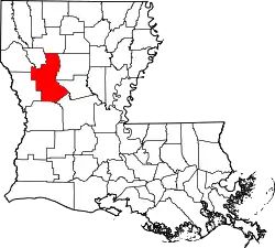 | |
| Town | ||
| Villages | ||
| CDPs | ||
| Other unincorporated communities |
| |
| Ghost towns |
| |
| Footnotes | ‡This populated place also has portions in an adjacent county or counties | |
| ||