National Highway 505 (India)
National Highway 505, commonly called NH 505, is a national highway in India.[1] It is a spur road of National Highway 5.[2] NH-505 traverses the state of Himachal Pradesh in India. NH505 a high altitude road, covers Kinnaur and Lahaul and Spiti districts of Himachal Pradesh, mainly running along Spiti river in Spiti valley. The highway from Kaza to Gramphu remains closed for 6-9 months in a year due to heavy snowfall and closure of Kunzum La pass at an altitude of 4,550 m (14,930 ft).[3][4]
| ||||
|---|---|---|---|---|
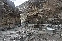
 Bridge across Spiti River | ||||
| Route information | ||||
| Auxiliary route of NH 5 | ||||
| Length | 275 km (171 mi) | |||
| Major junctions | ||||
| East end | Khab | |||
| West end | Gramphoo | |||
| Location | ||||
| States | Himachal Pradesh | |||
| Highway system | ||||
| ||||
Overview
National Highway 505, was designated Himachal state highway 30 prior to its being notified on 4 March 2014 as a national highway.[5] The highway runs through the high altitude cold desert area of Lahaul and Spiti valleys of Himachal, which area receives negligible rainfall.[1] The terrain is barren and treacherous, prone to landslides and disruptions. The road is narrow and rough at places and crosses the high altitude Kunzum pass, requiring good driving skills in mountains.[6] NH-505 provides connectivity to some major Buddhist monasteries and various interesting places.[7]
Route

The route of NH-505 starts at the Khab Sangam in Kinnaur district from National Highway 5. It runs along the Spiti valley through Kinnaur and enters Lahaul and Spiti district at Sumdo. It continues up the Spiti valley to Kunzum Pass. It descends and follows the Chandra River to the terminus at Gramphoo.[1]
| Town/Village | Up | Down |
|---|---|---|
| Khab Sangam | 0 km (0 mi) | 273 km (170 mi) |
| Nako | 26 km (16 mi) | 247 km (153 mi) |
| Chango | 48 km (30 mi) | 225 km (140 mi) |
| Sumdo | 62 km (39 mi) | 211 km (131 mi) |
| Hurling | 70 km (43 mi) | 203 km (126 mi) |
| Tabo | 89 km (55 mi) | 184 km (114 mi) |
| Kaza | 135 km (84 mi) | 138 km (86 mi) |
| Losar | 192 km (119 mi) | 81 km (50 mi) |
| Kunzum Pass | 210 km (130 mi) | 63 km (39 mi) |
| Batal | 221 km (137 mi) | 52 km (32 mi) |
| Chhatru | 253 km (157 mi) | 20 km (12 mi) |
| Gramphoo | 273 km (170 mi) | 0 km (0 mi) |
Kinnaur district
The terminus at Khab, Kinnaur district is the preferred point of entry to Spiti valley which is located at an average elevation of 3,350 m (10,990 ft).[4] This mostly all-weather access point to Spiti valley from Khab is at an elevation of about 2,600 m (8,500 ft). Travelling from Chandigarh or Shimla to Khab gives a chance for travellers to gradually acclimatize themselves to avoid altitude sickness. NH-505 climbs steeply from Khab Sangam up to Nako (3,662 m (12,014 ft)). It descends to Chango on the Spiti River, then enters Lahaul and Spiti district at Sumdo.
 NH-505 enters Spiti Valley from bridge over Sutlej river
 Enroute Khab to Nako
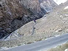 Switchback hairpin bends climbing to Nako
 Leo village on right bank of Spiti, opp. Nako
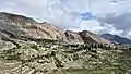
 Nako village from NH-505
  Enroute Nako to Chango
Lahaul and Spiti district
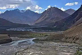
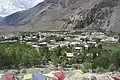
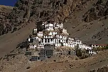
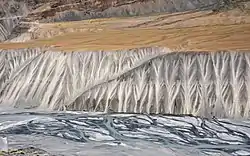
From Sumdo, NH-505 runs mostly alongside the Spiti river for about 130 km (81 mi) until Losar. After passing through Hurling, the next town is Tabo with the well-known Tabo Monastery and caves. The highway passes through some unusual clay pillars[9] en route to Kaza, the largest town in Spiti valley. Near Lingti, 15 km (9.3 mi) before Kaza, the 33 km (21 mi) road to Pin Valley National Park branches off over the Attargo Bridge to the right bank of the Spiti.[10] On the Tabo side of Lingti is the road to the Dhanker Monastery. In this section, the riverbed is very wide, up to 500 m (1,600 ft) in places. The river itself is much narrower and meanders in braids along the broad riverbed.[9]
 Tabo with Spiti River beneath distant cliff, Jun '18
 Clay pillars, Tabo - Lingti, Jun '18
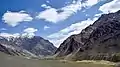 Pin Valley Nat'l Park, Mudh village, Jun '18
 Kaza in Spiti valley
After Kaza, NH-505 crosses to the right bank of the Spiti river over the Rangrik Bridge. At the bridge, the Kaza-Kibber road continues on the left bank to Key Monastery (8 km (5.0 mi)) and the Kibber Wildlife Sanctuary (15 km (9.3 mi)).[11] NH-505 continues on the right bank running through a flat, narrow valley in which the Spiti river has carved a gorge about 300 m (980 ft) deep. The road crosses back to the left bank 3 km (1.9 mi) before Kialto village. Here, the Kaza-Kibber road rejoins NH-505, a distance of 22 km (14 mi) from Kibber. After Morang and Hanse villages, the valley broadens before Losar village.
After Losar, NH-505 turns up the right bank of the Lichu, a right bank tributary of the Spiti. The road climbs gradually up to Kunzum La, elev. 4,551 m (14,931 ft). There is a temple at the pass.
 Spiti gorge above Kaza with NH-505 on the right bank (view from Kibber-Kialto road)
 Spiti gorge with NH-505 on the right and Kibber-Kialto road on the left.
 Enroute Kaza to Losar
 Bridge across Spiti river
 NH505 entering Losar from the east
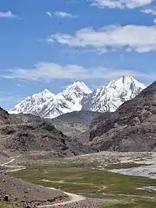 Losar-Kunzum Road
 Kunzum La, Elevation 4551 m
From Kunzum pass, the highway descends through steep hairpin bends to Batal village on the left bank of the Chandra river. Chandra Taal is a pristine lake on the Chandra River popular with tourists and high-altitude trekkers. The road to Chandra Taal branches off from NH-505 about 2.9 kilometres (1.8 mi) from Batal and 8 km (5.0 mi) from Kunzum Pass.[12]
From Batal, NH-505 follows the left bank of the Chandra river, practically running on the riverbed in some places as both sides of the narrow valley are very steep. This section is largely unpaved and impassable during the winter months. Passing through Chotta Dara the highway reaches Chhatru where it crosses to the right bank. It climbs steeply and runs along the top of a cliff overlooking the Chandra river until the terminus at Gramphu (Gramphoo).[5]
 Bara Shigri Glacier on the right bank of the Chandra
 NH-505 runs along Chandra riverbed below Batal
 Batal to Chhatru
 Chhatru village
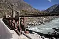 Chhatru to Gramphu
 Junction with NH3 on left at Gramphu
References
- "State-wise length of National Highways (NH) in India as on 30.06.2017". Ministry of Road Transport and Highways. Retrieved 5 July 2018.
- "New Numbering of National Highways notification - Government of India" (PDF). The Gazette of India. Retrieved 5 July 2018.
- "Access to Lahaul & Spiti district by road". Lahaul and Spiti district website. Retrieved 1 February 2019.
- "Status of roads in Lahaul and Spiti district". Lahaul and Spiti district. Retrieved 1 February 2019.
- "New highways notification dated March, 2014" (PDF). The Gazette of India - Ministry of Road Transport and Highways. Retrieved 5 July 2018.
- "How to drive to Spiti". Condé Nast Traveller. 10 April 2018.
- "15 places to visit in the beautiful valleys of Lahaul-Spiti". The Times of India - Times Travel. Retrieved 2 February 2019.
- "NH505 route: Khab Sangam to Gramphoo". OpenstreetMap.org. Retrieved 16 September 2020.
- Harcourt, A.F.P. (1871). The Himalayan Districts of Kooloo, Lahoul and Spiti. London: W.H. Allen & Sons. pp. 27, 29.
- "NH-505 Attargo Bridge to Mudh, Pin Valley". OpenStreetmap.org. Retrieved 27 September 2020.
- "Kaza-Kibber road". OpenStreetmap.org. Retrieved 27 September 2020.
- "Route from NH-505 to Chandra Taal". OpenStreetMap.org. Retrieved 26 September 2020.
| Wikimedia Commons has media related to NH 505 (India). |

Secondary routes of Indian National Highway 5 | ||
|---|---|---|
| States |  | |
| Secondary routes | ||