National Register of Historic Places listings in Humboldt County, Nevada
Contents: List of Registered Historic Places in Humboldt County, Nevada, USA:
The locations of National Register properties and districts (at least for all showing latitude and longitude coordinates below), may be seen in an online map by clicking on "Map of all coordinates".[1]
- This National Park Service list is complete through NPS recent listings posted January 29, 2021.[2]
Current listings
| [3] | Name on the Register | Image | Date listed[4] | Location | City or town | Description |
|---|---|---|---|---|---|---|
| 1 | Andorno Station | March 30, 1995 (#95000329) |
9535 U.S. Route 95, N. 41°27′28″N 117°48′02″W |
Winnemucca | ||
| 2 | Applegate-Lassen Trail | December 18, 1978 (#78001722) |
Trail extends from Rye Patch northwest to the state line 41°11′45″N 119°16′36″W |
Sulphur | ||
| 3 | Golconda School | 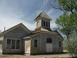 Golconda School |
November 14, 1991 (#91001651) |
Junction of Morrison and 4th Sts. 40°57′10″N 117°29′17″W |
Golconda | |
| 4 | Humboldt County Courthouse | Humboldt County Courthouse |
August 19, 1983 (#83001109) |
5th and Bridge Sts. 40°57′59″N 117°44′11″W |
Winnemucca | |
| 5 | Humboldt River Bridge | 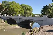 Humboldt River Bridge |
March 30, 1995 (#95000322) |
N. Bridge St. over the Humboldt River 40°58′35″N 117°44′17″W |
Winnemucca | |
| 6 | Last Supper Cave | December 6, 1975 (#75001111) |
Address Restricted |
Denio | ||
| 7 | Martin Hotel | .jpg.webp) Martin Hotel |
October 24, 2003 (#03001067) |
94 W. Railroad St. 40°58′15″N 117°43′50″W |
Winnemucca | |
| 8 | Micca House | 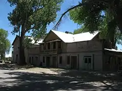 Micca House |
June 11, 1975 (#75001112) |
Bridge St. 41°29′34″N 117°31′54″W |
Paradise Valley | |
| 9 | Paradise Valley Ranger Station | 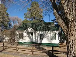 Paradise Valley Ranger Station |
June 19, 1996 (#96000662) |
355 S. Main St. in the Humboldt National Forest 41°29′20″N 117°32′01″W |
Paradise Valley | |
| 10 | W.C. Record House | 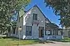 W.C. Record House |
August 27, 1980 (#80002467) |
146 W. 2nd St. 40°58′24″N 117°44′13″W |
Winnemucca | |
| 11 | Silver State Flour Mill | May 13, 1976 (#76001142) |
7 miles east of Paradise Valley off State Route 8B 41°30′44″N 117°26′19″W |
Paradise Valley | ||
| 12 | US Post Office-Winnemucca Main | 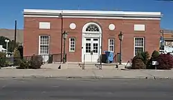 US Post Office-Winnemucca Main |
February 28, 1990 (#90000137) |
90 W. 4th St.[5] 40°58′21″N 117°44′02″W |
Winnemucca | Now used as Winnemucca City Hall |
| 13 | Winnemucca Grammar School | 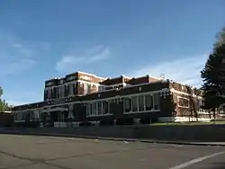 Winnemucca Grammar School |
November 14, 1991 (#91001654) |
522 Lay St. 40°58′12″N 117°44′01″W |
Winnemucca | |
| 14 | Winnemucca Hotel | .jpg.webp) Winnemucca Hotel |
May 26, 2005 (#05000471) |
95 S. Bridge St. 40°58′28″N 117°44′15″W |
Winnemucca |
See also
| Wikimedia Commons has media related to National Register of Historic Places in Humboldt County, Nevada. |
References
- The latitude and longitude information provided in this table was derived originally from the National Register Information System, which has been found to be fairly accurate for about 99% of listings. Some locations in this table may have been corrected to current GPS standards.
- "National Register of Historic Places: Weekly List Actions". National Park Service, United States Department of the Interior. Retrieved on January 29, 2021.
- Numbers represent an alphabetical ordering by significant words. Various colorings, defined here, differentiate National Historic Landmarks and historic districts from other NRHP buildings, structures, sites or objects.
- The eight-digit number below each date is the number assigned to each location in the National Register Information System database, which can be viewed by clicking the number.
- Address based on signage on the front of the building and City of Winnemucca website
This article is issued from Wikipedia. The text is licensed under Creative Commons - Attribution - Sharealike. Additional terms may apply for the media files.