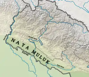
Naya Muluk
Naya Muluk (Nepali: नयाँ मुलुक) is a geographical region of Nepal, which is situated western-south part in Nepal. The Terai land between Kali River to Rapti River called "Naya Muluk" after 1860.[1][2]
Part of a series on the |
|---|
| History of Nepal |
 |
|
| Timeline |
|
|
History
After Anglo-Nepalese War in 1814-1816, Nepal was forced to sign a treaty called Sugauli Treaty in which Nepal lost one third part of geographical territory. The geographical territory was sectioned in five parts as below:
- The whole of the lowlands between the Rivers Kali and Rapti.
- The whole of the low lands lying between the Rapti and the Gunduck.
- The whole of the lowlands between the Gunduck and Coosah.
- All the low lands between the Rivers Mitchee and the Teestah.
- All the territories within the hills eastward of the River Mitchee and all territories westards of Kali.
Section: 2 and 3 (whole land from Rapti to Gundak and Gandak to Koshi) restored back to Nepal on December 11, 1816.
Section: 1 (whole low land between the Rivers Kali and Rapti) returned in 1860 called Naya Muluk.
Territory
Naya muluk contains two district of Sudurpashchim province and two district of Province No. 5. Total area is 9,207 square kilometres (3,555 sq mi) and total population is 2144,846.
| Districts | Area (KM2) | Population |
|---|---|---|
| Kanchanpur | 1,610 | 451,248 |
| Kailali | 3,235 | 775,709 |
| Bardia | 2,025 | 426,576 |
| Banke | 2,337 | 491,313 |
References
- "Using 'Shikar Diplomacy' in 19th-Century Nepal". Retrieved 29 February 2020.
... what was then called ‘Naya Muluk’, a strip of Terai flatlands the British had returned to Nepal in gratitude in 1860 and today encompassing the districts of Kailali, Banke, Bardiya and Kanchanpur.
- "International Boundary Survey and Demarcation of South-eastern portion of Nepal with India" (PDF). Retrieved 29 February 2020.
External links
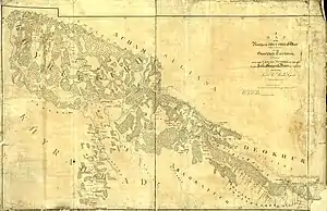
- A map by survey of India of 1934 showing Naya Mulk
- https://www.spotlightnepal.com/2018/11/13/centenary-end-first-world-war-celebrations-all-over-world-except-nepal/
- http://himalaya.socanth.cam.ac.uk/collections/journals/contributions/pdf/CNAS_02_01_13.pdf
- https://books.google.co.uk/books?id=D7Oga-GvExMC&pg=PA64&lpg=PA64&dq=Naya+muluk&source=bl&ots=SWySzhFfCy&sig=ACfU3U3FOgXd14_bVQgz4AxRS512aOFp9Q&hl=en&sa=X&ved=2ahUKEwj48ZyUn_bnAhXHfn0KHarBC6gQ6AEwBXoECAgQAQ
- https://www.tandfonline.com/doi/abs/10.1080/09700160802309233
- https://indiankanoon.org/docfragment/1687413/?big=3&formInput=nepal&__cf_chl_jschl_tk__=f0f4e1f5938bf7e2527a04c04555de28f0d0141d-1606093766-0-AeJ5IcIog4iiL_LUMZUjjsWoLmfhe3AkM-8I6tRiheum6qbyhP-PQX2LH_6KxzlLIbrqaWteOtq8MjVGGsn1gE1UPYelcvJBMzqoPS4IUPwRPG2cKqfzR3_-RKSpQ0AQFnAGYJXB6FyE-ihtOD_EORU9CUxl14GjVHIquRg3jREEeEru2HdWxy5yMnzS0-C4BvXJn2rmfPuo6wjYCa9eHxbXGPe8pH6ZRNbIrZPQ3QRAM4DB-4FDjgxNqaXUlqeZCWKQOzACIU5sFik2EnG0NbJKgD14e_GXCTtk0em2wrN05YE8CfXHFPc9RcpdmGx6dJt_AfY6c6ZgcJ-LZ780uGIxcqCdKXhmNF5J-ZeFCfx0AkR5ajy9z04cdN2Oo77HUBL56pS43RS8TSzUCCSo6SVVurpkO-KDUIq72fjZqKQY