Bardiya District
Bardiya District (Nepali: बर्दिया जिल्ला![]() Listen ), one of the seventy-seven Districts of Nepal, is part of Lumbini Province of Nepal. The district, with Gulariya as its headquarters, covers an area of 2,025 km2 (782 sq mi) and according to the 2001 census the population was 382,649[2] in 2011 it has 426,576.[1]
Listen ), one of the seventy-seven Districts of Nepal, is part of Lumbini Province of Nepal. The district, with Gulariya as its headquarters, covers an area of 2,025 km2 (782 sq mi) and according to the 2001 census the population was 382,649[2] in 2011 it has 426,576.[1]
Bardiya District
बर्दिया | |
|---|---|
District | |
 Location of Bardiya (dark yellow) in Lumbini province | |
| Country | |
| Province | Lumbini Province |
| Admin HQ. | Gulariya |
| Government | |
| • Type | Coordination committee |
| • Body | DCC, Bardiya |
| Area | |
| • Total | 2,025 km2 (782 sq mi) |
| Population (2011)[1] | |
| • Total | 426,576 |
| • Density | 210/km2 (550/sq mi) |
| Time zone | UTC+05:45 (NPT) |
| Telephone Code | 084 |
| Main language(s) | Tharu, Nepali, Awadhi |
Geography and climate
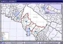
Bardiya lies in Lumbini Province in midwestern Nepal. It covers 2025 square kilometers and lies west of Banke District, south of Surkhet District of Karnali Province, east of Kailali District of Sudurpashchim province. To the south lies Uttar Pradesh, India.
Most of Bardiya is in the fertile Terai plains, covered with agricultural land and forest. The northernmost part of the district extends into the Churiya or Siwalik Hills. Bardiya National Park covers 968 km2 (374 sq mi) occupies most of the northern half of the district. This park is the largest undisturbed wilderness in Nepal's Terai. It provides forest, grassland and riverine habitat for endangered mammal, bird and reptile species. More than 30 species of mammals and more than 250 of birds have been recorded.
Most people living in this district are farmers. The district headquarter Gulariya lies on the Babai River. The Karnali, one of Nepal's largest rivers, divided into multiple branches when it reaches the Terai. The westernmost branch forms the boundary between Bardiya and Kailali districts. An eastern branch is called the Geruwa. The endangered Gangetic dolphin was often seen in its waters, but populations have been declining.[3]
| Climate zone[4] | Elevation range | % of area |
|---|---|---|
| Lower tropical | below 300 meters (1,000 ft) | 71.4% |
| Upper tropical | 300 to 1,000 meters 1,000 to 3,300 ft. |
22.6% |
| Subtropical | 1,000 to 2,000 meters 3,300 to 6,600 ft. |
2.7% |
History
Nepal lost it to the East India Company after Anglo-Nepalese war (1814–1816) between the then Kingdom of Nepal and East India Company followed by territorial concessions of Sugauli Treaty.[5] Later during the administration of Jang Bahadur Rana, it was returned to Nepal along with Banke, Kailali and Kanchanpur. In the early twentieth century, Bardiya was still covered with forest and sparsely populated with indigenous tribal people called Tharu. Additional Tharus immigrated west from Dang and Deukhuri Valleys. Tharu from Dang and Deukhuri make up a majority of Bardiya's population. Other tribes called Sonaha live near the Karnali River and western periphery of Bardia National Park, who are historically engaged in extracting golden ores from sediments of river and fishing.
Demographics
At the time of the 2011 Nepal census, Bardiya District had a population of 426,576. Of these, 52.0% spoke Tharu, 35.5% Nepali, 7.1% Awadhi, 2.3% Urdu and 0.7% Magar as their first language.[6]
Administration
The district consists of eight municipalities, out of which six are urban municipalities and two are rural municipalities. These are as follows:[7]
- Gulariya municipality
- Rajapur municipality
- Madhuwan municipality
- Thakurbaba municipality
- Basgadhi municipality
- Barbardiya municipality
- Badhaiyatal rural municipality
- Geruwa rural municipality
Former village development committees
Prior to the restructuring of the district, Bardiya District consisted of the following municipalities and Village development committees:
- Badalpur Nepal
- Baganaha
- Baniyabhar
- Belawa
- Bhimapur
- Deudakala
- Dhadhawar
- Dhodhari
- Gola
- Jamuni
- Kalika
- Khairapur
- Khairi Chandanpur
- Magaragadi
- Mahamadpur
- Manau
- Manpur Mainapokhar
- Manpur Tapara
- Mathurahardwar
- Motipur
- Naya Gaun
- Neulapur
- Padanaha
- Pasupatinagar
- Patabhar
- Sanesri
- Shivapur
- Sorhawa
- Suryapatawa
- Taratal
- Thakudwara
References
- "National Population and Housing Census 2011(National Report)" (PDF). Central Bureau of Statistics. Government of Nepal. November 2012. Archived from the original (PDF) on 18 April 2013. Retrieved 1 November 2012.
- "Nepal Census 2001". Nepal's Village Development Committees. Digital Himalaya. Archived from the original on 12 October 2008. Retrieved 12 December 2008.
- "River dolphins under threat in Nepal". WWF. 26 May 2006. Retrieved 26 May 2006.
- The Map of Potential Vegetation of Nepal – a forestry/agroecological/biodiversity classification system (PDF), . Forest & Landscape Development and Environment Series 2-2005 and CFC-TIS Document Series No.110., 2005, ISBN 87-7903-210-9, retrieved 22 November 2013
- "History of Nepal Army". Official website of Nepal Army. Archived from the original on 7 June 2011. Retrieved 18 May 2017.
- 2011 Nepal Census, Social Characteristics Tables
- "स्थानिय तह" (in Nepali). Ministry of Federal Affairs and General Administration. Archived from the original on 31 August 2018. Retrieved 1 October 2018.
See also
- Zones of Nepal
- "Districts of Nepal". Statoids.
Headquarter: Gulariya | ||
| Municipalities | 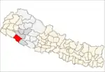 | |
| Rural municipalities | ||
| Former VDCs | ||
List of municipalities and rural municipalities of Nepal | ||
| Wikimedia Commons has media related to Bardiya District. |