Nea Kydonia
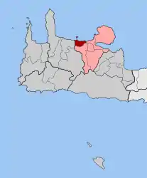
Nea Kydonia (Greek: Νέα Κυδωνία) is a former municipality in the Chania regional unit, Crete, Greece. Since the 2011 local government reform it is part of the municipality Chania, of which it is a municipal unit.[2] The municipal unit has an area of 21.457 km2 (8.285 sq mi).[3] It is situated on the western outskirts of Chania. It saw fierce fighting during the Battle of Crete during World War II and there the main prisoner of war camp for Allied soldiers in Western Crete was in Galatas.
Nea Kydonia
Νέα Κυδωνία | |
|---|---|
 Nea Kydonia Location within the regional unit  | |
| Coordinates: 35°30′N 23°57′E | |
| Country | Greece |
| Administrative region | Crete |
| Regional unit | Chania |
| Municipality | Chania |
| • Municipal unit | 21.5 km2 (8.3 sq mi) |
| Population (2011)[1] | |
| • Municipal unit | 10,771 |
| • Municipal unit density | 500/km2 (1,300/sq mi) |
| Time zone | UTC+2 (EET) |
| • Summer (DST) | UTC+3 (EEST) |
| Postal code | 731 00 |
| Area code(s) | 28210 |
| Vehicle registration | ΧΝ, XB |
| Website | www.nea-kydonia.gr |
The seat of the municipality of Nea Kydonia was in the village of Daratsos. Galatas has a popular beach at Kalamaki and a port called Kato Galatas. Agia Marina, Stalos and Daratso are other principal settlements of the municipality, as well as the uninhabited island of Agii Theodori. It was part of the former province of Kydonia.
Ancient History
Nearby in the modern city of Chania, is the ancient city of Kydonia, over whose ruins the modern city has been built.[4] Kydonia was a powerful Cretan city in the period 600 to 200 BC.
Line notes
- "Απογραφή Πληθυσμού - Κατοικιών 2011. ΜΟΝΙΜΟΣ Πληθυσμός" (in Greek). Hellenic Statistical Authority.
- Kallikratis law Greece Ministry of Interior (in Greek)
- "Population & housing census 2001 (incl. area and average elevation)" (PDF) (in Greek). National Statistical Service of Greece.
- Hogan, 2008
References
- National Statistical Service of Greece (ΕΣΥΕ). (Greek)
- C. Michael Hogan, Cydonia, The Modern Antiquarian, Jan. 23, 2008