Nebraska Highway 112
Nebraska Highway 112 is a highway in southeastern Nebraska. Its western terminus is at the Kansas border where it continues as K-148 southwest of Odell. Its eastern terminus is at U.S. Highway 77 west of Blue Springs.
| ||||
|---|---|---|---|---|
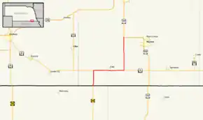 Nebraska Highway 112 highlighted in red | ||||
| Route information | ||||
| Maintained by NDOT | ||||
| Length | 15.69 mi[1] (25.25 km) | |||
| Existed | 1939[2]–present | |||
| Major junctions | ||||
| West end | ||||
| East end | ||||
| Location | ||||
| Counties | Gage | |||
| Highway system | ||||
| ||||

Route description
Nebraska Highway 112 begins at the border with Kansas, where it meets K-148. The highway heads north through farmland where it meets NE 8. It runs concurrently with NE 8 heading eastward through Odell. A few miles outside of Odell, the highway turns to the north again. It then continues northward until it terminates at US 77 west of Wymore.[1][3]
Major intersections
The entire route is in Gage County.
| Location | mi[1] | km | Destinations | Notes | |
|---|---|---|---|---|---|
| Glenwood Township | 0.00 | 0.00 | Continuation into Kansas; former K-15E | ||
| 3.04 | 4.89 | South end of N-8 overlap | |||
| Paddock Township | 9.08 | 14.61 | North end of N-8 overlap | ||
| Sicily Township | 15.57– 15.69 | 25.06– 25.25 | Northern terminus | ||
1.000 mi = 1.609 km; 1.000 km = 0.621 mi
| |||||
References
- "Nebraska Highway Reference Log Book" (PDF). Nebraska Department of Roads. 2015. p. 265. Retrieved January 7, 2017.
- Nebraska Roads: NE 101-119
- Google (2010-11-02). "overview of Nebraska Highway 112" (Map). Google Maps. Google. Retrieved 2010-11-02.
External links
This article is issued from Wikipedia. The text is licensed under Creative Commons - Attribution - Sharealike. Additional terms may apply for the media files.