Gage County, Nebraska
Gage County is a county in the U.S. state of Nebraska. As of the 2010 United States Census, the population was 22,311.[1] Its county seat is Beatrice.[2] The county was created in 1855 and organized in 1857.[3][4][5] It was formed from land taken from the Otoe in an 1854 treaty. The county was named for W.D. Gage, a Methodist minister.[6][7]
Gage County | |
|---|---|
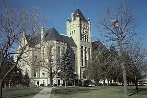 Gage County Courthouse in Beatrice, 1976 | |
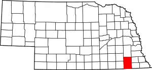 Location within the U.S. state of Nebraska | |
 Nebraska's location within the U.S. | |
| Coordinates: 40°16′N 96°41′W | |
| Country | |
| State | |
| Founded | 1855 (authorized) 1857 (organized) |
| Seat | Beatrice |
| Largest city | Beatrice |
| Area | |
| • Total | 860 sq mi (2,200 km2) |
| • Land | 852 sq mi (2,210 km2) |
| • Water | 8.5 sq mi (22 km2) 1.0%% |
| Population | |
| • Estimate (2018) | 21,493 |
| • Density | 25.4/sq mi (9.8/km2) |
| Time zone | UTC−6 (Central) |
| • Summer (DST) | UTC−5 (CDT) |
| Congressional district | 3rd |
| Website | www |
Gage County comprises the Beatrice, NE Micropolitan Statistical Area, which is also in the Lincoln-Beatrice, NE Combined Statistical Area.
In the Nebraska license plate system, Gage County is represented by the prefix 3 (it had the third-largest number of vehicles registered in the county when the license plate system was established in 1922).
Geography
Gage County lies on the south line of Nebraska. Its south boundary line abuts the north boundary line of the state of Kansas. The Big Blue River runs SSE through the central part of the county.
According to the US Census Bureau, the county has a total area of 860 square miles (2,200 km2), of which 851 square miles (2,200 km2) is land and 8.5 square miles (22 km2) (1.0%) is water.[8]
Major highways
Adjacent counties
- Lancaster County - north
- Otoe County - northeast
- Johnson County - northeast
- Pawnee County - east
- Marshall County, Kansas - southeast
- Washington County, Kansas - southwest
- Jefferson County - west
- Saline County - northwest
Protected areas
- Homestead National Monument
- Rockford Lake State Recreation Area[9]
Demographics
| Historical population | |||
|---|---|---|---|
| Census | Pop. | %± | |
| 1860 | 421 | — | |
| 1870 | 3,359 | 697.9% | |
| 1880 | 13,164 | 291.9% | |
| 1890 | 36,344 | 176.1% | |
| 1900 | 30,051 | −17.3% | |
| 1910 | 30,325 | 0.9% | |
| 1920 | 29,721 | −2.0% | |
| 1930 | 30,242 | 1.8% | |
| 1940 | 29,588 | −2.2% | |
| 1950 | 28,052 | −5.2% | |
| 1960 | 26,818 | −4.4% | |
| 1970 | 25,731 | −4.1% | |
| 1980 | 24,456 | −5.0% | |
| 1990 | 22,794 | −6.8% | |
| 2000 | 22,993 | 0.9% | |
| 2010 | 22,311 | −3.0% | |
| 2018 (est.) | 21,493 | [10] | −3.7% |
| US Decennial Census[11] 1790-1960[12] 1900-1990[13] 1990-2000[14] 2010-2013[1] | |||
As of the 2000 United States Census,[15] there were 22,993 people, 9,316 households, and 6,204 families in the county. The population density was 27 people per square mile (10/km2). There were 10,030 housing units at an average density of 12 per square mile (5/km2). The racial makeup of the county was 97.69% White, 0.32% Black or African American, 0.58% Native American, 0.28% Asian, 0.03% Pacific Islander, 0.26% from other races, and 0.84% from two or more races. 0.85% of the population were Hispanic or Latino of any race. 56.6% were of German, 6.9% Irish, 6.3% English and 6.3% American ancestry.
There were 9,316 households, out of which 30.30% had children under the age of 18 living with them, 56.70% were married couples living together, 7.10% had a female householder with no husband present, and 33.40% were non-families. 29.20% of all households were made up of individuals, and 15.00% had someone living alone who was 65 years of age or older. The average household size was 2.36 and the average family size was 2.91.
The county population contained 24.00% under the age of 18, 7.70% from 18 to 24, 26.30% from 25 to 44, 22.80% from 45 to 64, and 19.20% who were 65 years of age or older. The median age was 40 years. For every 100 females there were 94.10 males. For every 100 females age 18 and over, there were 91.40 males.
The median income for a household in the county was $34,908, and the median income for a family was $43,072. Males had a median income of $29,680 versus $21,305 for females. The per capita income for the county was $17,190. About 6.60% of families and 8.70% of the population were below the poverty line, including 9.70% of those under age 18 and 8.00% of those age 65 or over.
Politics
Prior to 1940, Gage County was a swing county, backing the national winner in every presidential election from 1900 to 1936. Since then, it has become a Republican stronghold, aside from the 1964 election in which Democrat Lyndon B. Johnson won the county in the midst of his national landslide victory.
| Year | Republican | Democratic | Third Parties |
|---|---|---|---|
| 2020 | 67.0% 7,445 | 30.4% 3,385 | 2.6% 289 |
| 2016 | 63.5% 6,380 | 29.2% 2,935 | 7.3% 733 |
| 2012 | 57.1% 5,513 | 40.4% 3,903 | 2.5% 245 |
| 2008 | 53.5% 5,435 | 44.0% 4,473 | 2.5% 252 |
| 2004 | 63.3% 6,575 | 35.2% 3,655 | 1.5% 154 |
| 2000 | 58.3% 5,538 | 37.0% 3,516 | 4.8% 452 |
| 1996 | 44.8% 4,413 | 40.7% 4,008 | 14.4% 1,422 |
| 1992 | 39.7% 4,006 | 32.8% 3,315 | 27.6% 2,783 |
| 1988 | 55.7% 5,115 | 43.6% 4,008 | 0.7% 63 |
| 1984 | 68.8% 6,116 | 30.5% 2,709 | 0.8% 67 |
| 1980 | 66.2% 6,089 | 24.6% 2,259 | 9.3% 853 |
| 1976 | 52.5% 5,199 | 45.5% 4,506 | 1.9% 190 |
| 1972 | 63.7% 6,298 | 36.3% 3,588 | |
| 1968 | 55.7% 5,465 | 37.8% 3,704 | 6.5% 637 |
| 1964 | 38.6% 4,035 | 61.4% 6,411 | |
| 1960 | 66.8% 7,754 | 33.2% 3,861 | |
| 1956 | 67.6% 7,514 | 32.4% 3,595 | |
| 1952 | 73.9% 8,917 | 26.1% 3,154 | |
| 1948 | 56.3% 5,311 | 43.7% 4,124 | |
| 1944 | 63.4% 7,352 | 36.6% 4,238 | |
| 1940 | 61.6% 8,156 | 38.5% 5,096 | |
| 1936 | 41.5% 5,291 | 56.7% 7,227 | 1.8% 227 |
| 1932 | 37.3% 4,315 | 60.7% 7,036 | 2.0% 234 |
| 1928 | 69.8% 8,378 | 29.4% 3,526 | 0.8% 94 |
| 1924 | 50.7% 5,331 | 31.7% 3,330 | 17.6% 1,853 |
| 1920 | 69.0% 6,059 | 28.2% 2,477 | 2.9% 250 |
| 1916 | 48.7% 3,383 | 48.7% 3,385 | 2.6% 177 |
| 1912 | 21.1% 1,336 | 40.9% 2,593 | 38.1% 2,419 |
| 1908 | 52.8% 3,721 | 44.4% 3,129 | 2.8% 200 |
| 1904 | 69.9% 4,304 | 21.6% 1,330 | 8.5% 526 |
| 1900 | 58.7% 4,141 | 38.3% 2,701 | 3.1% 219 |
References
- "State & County QuickFacts". US Census Bureau. Archived from the original on June 7, 2011. Retrieved September 20, 2013.
- "Find a County". National Association of Counties. Archived from the original on 31 May 2011. Retrieved 7 June 2011.
- Fitzpatrick, Lilian Linder (1925). Nebraska Place-Names. Lincoln: University of Nebraska Studies in Language, Literature, and Criticism. p. 63. Retrieved December 18, 2014.
- Andreas, A. T. (1882). "Andreas' History of the State of Nebraska". The Kansas Collection. Archived from the original on 2003-01-05. Retrieved December 18, 2014.
- "Gage County". Nebraska Association of County Officials. Retrieved December 18, 2014.
- Gage County History (archived)
- Gannett, Henry (1905). The Origin of Certain Place Names in the United States. Govt. Print. Off. p. 133.
- "2010 Census Gazetteer Files". US Census Bureau. August 22, 2012. Archived from the original on November 13, 2013. Retrieved December 7, 2014.
- Rockford Lake State Recreation Area, Beatrice NE Google Maps (accessed 21 January 2019)
- "Population and Housing Unit Estimates". Retrieved December 26, 2019.
- "US Decennial Census". US Census Bureau. Retrieved December 7, 2014.
- "Historical Census Browser". University of Virginia Library. Retrieved December 7, 2014.
- "Population of Counties by Decennial Census: 1900 to 1990". US Census Bureau. Retrieved December 7, 2014.
- "Census 2000 PHC-T-4. Ranking Tables for Counties: 1990 and 2000" (PDF). US Census Bureau. Retrieved December 7, 2014.
- "U.S. Census website". US Census Bureau. Retrieved 31 January 2008.
- Election Results
External links
| Wikimedia Commons has media related to Gage County, Nebraska. |
Places adjacent to Gage County, Nebraska | |
|---|---|
Municipalities and communities of Gage County, Nebraska, United States | ||
|---|---|---|
| Cities | Map of Nebraska highlighting Gage County | |
| Villages | ||
| Townships | ||
| CDP | ||
| Unincorporated communities | ||
| Footnotes | ‡This populated place also has portions in an adjacent state | |
| ||

| Authority control |
|---|