Nebraska Highway 29
Nebraska Highway 29 is a highway in western Nebraska. It runs for 56 miles (90 km). It has a southern terminus at U.S. Highway 26 in Mitchell and a northern terminus at U.S. Highway 20 in Harrison.
| ||||
|---|---|---|---|---|
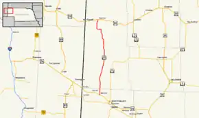 Nebraska Highway 29 highlighted in red | ||||
| Route information | ||||
| Maintained by NDOT | ||||
| Length | 55.81 mi[1] (89.82 km) | |||
| Existed | 1925[2]–present | |||
| Major junctions | ||||
| South end | ||||
| North end | ||||
| Location | ||||
| Counties | Scotts Bluff, Sioux | |||
| Highway system | ||||
| ||||

Route description
Nebraska Highway 29 begins in Mitchell at US 26. It proceeds north for 33 miles (53 km) to Agate and the Agate Fossil Beds National Monument, where the highway crosses the Niobrara River. It continues north, with a short westerly segment, to Harrison, where it meets US 20 and ends.[1][3]
Major intersections
| County | Location | mi[1] | km | Destinations | Notes |
|---|---|---|---|---|---|
| Scotts Bluff | Mitchell | 0.00 | 0.00 | 19th Avenue south – North Platte River, N-92 | Continuation south beyond southern terminus |
| Southern terminus | |||||
| Sioux | Harrison | 55.81 | 89.82 | Northern terminus | |
| Main Street north – Gilbert-Baker Wildlife Area | Continuation north beyond northern terminus | ||||
| 1.000 mi = 1.609 km; 1.000 km = 0.621 mi | |||||
References
- "Nebraska Highway Reference Log Book" (PDF). Nebraska Department of Roads. 2015. p. 93. Retrieved January 7, 2017.
- Nebraska Roads: NE 21-40
- Google (2010-11-01). "overview of Nebraska Highway 29" (Map). Google Maps. Google. Retrieved 2010-11-01.
External links
| Wikimedia Commons has media related to Nebraska Highway 29. |
This article is issued from Wikipedia. The text is licensed under Creative Commons - Attribution - Sharealike. Additional terms may apply for the media files.