Nebraska Highway 53
Nebraska Highway 53 is a highway in southern Nebraska. It is a north–south highway which runs for 12 miles (19 km). It has a southern terminus at U.S. 136 east of Gilead, and a northern terminus west of Daykin at Nebraska Highway 4.
| ||||
|---|---|---|---|---|
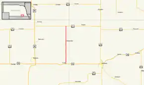 Nebraska Highway 53 highlighted in red | ||||
| Route information | ||||
| Maintained by NDOT | ||||
| Length | 12.04 mi[1] (19.38 km) | |||
| Existed | January 1, 1975[2]–present | |||
| Major junctions | ||||
| South end | ||||
| North end | ||||
| Location | ||||
| Counties | Thayer | |||
| Highway system | ||||
| ||||

Route description
Nebraska Highway 53 begins one mile (1.6 km) east of Gilead at U.S. 136. It proceeds north through farmland and crosses the Little Blue River before entering Alexandria. From Alexandria, it continues north until NE 4, where it ends.[1][3]
Major intersections
The entire route is in Thayer County.
| Location | mi[1] | km | Destinations | Notes | |
|---|---|---|---|---|---|
| Gilead | 0.00 | 0.00 | Southern terminus | ||
| Daykin | 12.04 | 19.38 | Northern terminus | ||
| 1.000 mi = 1.609 km; 1.000 km = 0.621 mi | |||||
References
- "Nebraska Highway Reference Log Book" (PDF). Nebraska Department of Roads. 2015. p. 150. Retrieved January 7, 2017.
- "New Numbers for Highway Segments". The Beatrice Daily Sun. Beatrice, Nebraska. November 18, 1974. p. 1. Retrieved December 18, 2019 – via Newspapers.com.

- Google (2010-11-01). "overview of Nebraska Highway 53" (Map). Google Maps. Google. Retrieved 2010-11-01.
External links
This article is issued from Wikipedia. The text is licensed under Creative Commons - Attribution - Sharealike. Additional terms may apply for the media files.