Nevada State Route 159
State Route 159 (SR 159) is a 31.204-mile (50.218 km) east–west highway in Clark County, Nevada, United States, providing access to Red Rock Canyon and serving as a thoroughfare in the Las Vegas metropolitan area. A portion of the west end of the route is designated a Nevada Scenic Byway.
| ||||
|---|---|---|---|---|
 Nevada State Route 159, highlighted in red. | ||||
| Route information | ||||
| Maintained by NDOT | ||||
| Length | 18.524 mi[1] (29.811 km) | |||
| Existed | 1978–present | |||
| Major junctions | ||||
| Section 1 | ||||
| Length | 15.833 mi[1] (25.481 km) | |||
| West end | ||||
| East end | ||||
| Section 2 | ||||
| Length | 0.337 mi[1] (0.542 km) | |||
| West end | Martin Luther King Boulevard | |||
| East end | Grand Central Parkway | |||
| Section 3 | ||||
| Length | 2.354 mi[1] (3.788 km) | |||
| West end | ||||
| East end | ||||
| Location | ||||
| Counties | Clark | |||
| Highway system | ||||
| ||||

Route description
_from_the_%22west%22_end_of_Nevada_State_Route_159_(Blue_Diamond_Road)_near_Las_Vegas%252C_Nevada.jpg.webp)
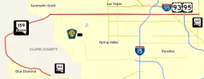
State Route 159 has two distinct segments. The first segment is a rural two-lane highway that begins at its junction with SR 160. The highway proceeds northwest through the town of Blue Diamond towards Spring Mountain Ranch State Park. From there, the highway curves northeast around Red Rock Canyon to the Las Vegas city limits west of the Las Vegas Beltway. This segment of SR 159 is known on maps and signs as Blue Diamond Road (assuming the name from SR 160), but is also referred to as Red Rock Canyon Road.
As SR 159 enters the city of Las Vegas, it transitions into Charleston Boulevard, a major east–west section line arterial bisecting the Las Vegas Valley. The highway crosses the Las Vegas Beltway and runs through the planned community of Summerlin. SR 159 continues east to intersect Interstate 15 and then passes south of Downtown Las Vegas. From there, the highway ventures further east to intersect Interstate 515 and U.S. Routes 93 and 95 before reaching its terminus at Nellis Boulevard (SR 612). (Charleston Boulevard itself ends about three miles (5 km) east of Nellis Boulevard near Frenchman Mountain.)
History

A portion of Charleston Boulevard was previously designated U.S. Route 95 Alternate to bypass Downtown Las Vegas. The designation began at Fremont Street (SR 582) and continued west to Rancho Drive (SR 599), where it curved north to reconnect to US 95. The alternate route was discontinued in 1982.
Approximately 8.8 miles (14.2 km) of SR 159 in Red Rock Canyon was designated a Nevada Scenic Byway on June 30, 1995.[2]
Major intersections
The entire route is in Clark County.
| Location | mi[3] | km | Destinations | Notes | |||
|---|---|---|---|---|---|---|---|
| Blue Diamond | 0.00 | 0.00 | Counterclockwise terminus; road continues south as Erskine Junction Way | ||||
| Las Vegas–Summerlin South line | 15.833 | 25.481 | Interchange; future I-215; CC 215 exit 26 | ||||
| Gap in route | |||||||
| Las Vegas | 15.833 | 25.481 | Martin L. King Boulevard | Interchange; eastbound left exit and westbound entrances; under construction (ramp from MLK Blvd. SB to SR 159 west open) | |||
| Interchange; I-15 exit 41 | |||||||
| 16.17 | 26.02 | Grand Central Boulevard | |||||
| Gap in route | |||||||
| Las Vegas–Sunrise Manor line | 16.17 | 26.02 | Fremont Street (SR 582) | ||||
| Interchange; I-515 exit 72 | |||||||
| 18.524 | 29.811 | Nellis Boulevard (SR 612) | Clockwise terminus; road continues east as Charleston Boulevard | ||||
| 1.000 mi = 1.609 km; 1.000 km = 0.621 mi | |||||||
Public Transport
Current RTC route 206 functions on this road.
See also
- List of state highways in Nevada
References
- Nevada Department of Transportation (January 2020). "State Maintained Highways of Nevada: Descriptions and Maps". Retrieved April 26, 2020.
- Nevada Department of Transportation. "Nevada's Scenic Byways". Retrieved March 24, 2008.
- "Overview of SR 159". Google Maps. Google, Inc. Retrieved March 31, 2020.
External links
![]() Media related to Nevada State Route 159 at Wikimedia Commons
Media related to Nevada State Route 159 at Wikimedia Commons