Nevada State Route 265
State Route 265 (SR 265) is a 20.5-mile (33.0 km) state highway in Esmeralda County, Nevada, United States. Referred to as Silver Peak Road, it connects the community of Silver Peak to U.S. Route 6 and U.S. Route 95 (US 6–95). The route formerly existed as State Route 47.
| ||||
|---|---|---|---|---|
| Silver Peak Road | ||||
 | ||||
| Route information | ||||
| Maintained by NDOT | ||||
| Length | 20.500 mi[1] (32.992 km) | |||
| Existed | 1976–present | |||
| Major junctions | ||||
| South end | Silver Peak Road in Silver Peak | |||
| North end | ||||
| Location | ||||
| Counties | Esmeralda | |||
| Highway system | ||||
| ||||

Route description
_at_U.S._Routes_6_and_95_in_Esmeralda_County%252C_Nevada.jpg.webp)
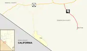
SR 265 starts at Silver Peak Road (an unrelated road heading east) just southwest of Silver Peak. The highway curves north as the main road through the town. Outside of Silver Peak, the route heads north and slightly westward through the desert. SR 265 ends at Blair Junction on US 6–95, approximately 6 miles (9.7 km) east of Coaldale.
History
Silver Peak Road first appears on the 1935 edition of the official state highway map. This version shows it as State Route 47, an unimproved highway.[2] The entire road had been paved by 1940.[3] SR 47 remained relatively unchanged until ca. 1978, when the highway was rechristened as State Route 265.[4]
Major intersections
Mileposts along SR 265 are assigned from north to south. The entire route is in Esmeralda County.
| Location | mi[5] | km | Destinations | Notes | |
|---|---|---|---|---|---|
| Silver Peak | 20.50 | 32.99 | Silver Peak Road | ||
| | 0.00 | 0.00 | |||
| 1.000 mi = 1.609 km; 1.000 km = 0.621 mi | |||||
See also
 United States portal
 U.S. Roads portal
References
- Nevada Department of Transportation (January 2017). "State Maintained Highways of Nevada: Descriptions and Maps". Retrieved 2017-04-17.
- Official Road Map of Nevada (Map). Nevada Department of Highways. 1935. Retrieved January 11, 2009.
- Official Road Map of the State of Nevada (Map). Nevada Department of Highways. 1940. Retrieved January 11, 2009.
- Official Highway Map of Nevada (Map) (1978-79 ed.). Nevada Department of Highways. 1978. Archived from the original on February 9, 2011. Retrieved January 11, 2009.
- Nevada Department of Transportation (May 2008). "Maps of Milepost Location on Nevada's Federal and State Highway System by County" (PDF). Archived from the original (PDF) on January 4, 2011. Retrieved January 11, 2009.
| Wikimedia Commons has media related to Nevada State Route 265. |