U.S. Route 6 in Nevada
U.S. Route 6 (US 6) is a transcontinental highway in the United States, stretching from Bishop, California, in the west to Provincetown, Massachusetts, on the east coast. The Nevada portion crosses the center of the state, serving the cities of Tonopah and Ely, en route to Utah and points further east. Like US 50, to the north, large desolate areas are traversed by the route, with few or no signs of civilization, and the highway crosses several large desert valleys separated by numerous mountain ranges towering over the valley floors, in what is known as the Basin and Range Province of the Great Basin.
| ||||
|---|---|---|---|---|
| Grand Army of the Republic Highway Theodore Roosevelt Highway | ||||
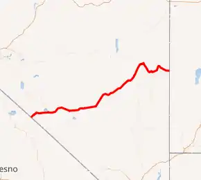
US 6 highlighted in red | ||||
| Route information | ||||
| Maintained by NDOT | ||||
| Length | 305.723 mi[1] (492.013 km) | |||
| Existed | 1937–present | |||
| Major junctions | ||||
| West end | ||||
| East end | ||||
| Location | ||||
| Counties | Mineral, Esmeralda, Nye, White Pine | |||
| Highway system | ||||
| ||||

US 6 has a diverse route through the state, traversing desert, desert mountain ranges and valleys, ghost towns and Great Basin National Park. The entire highway in Nevada is designated as part of the Grand Army of the Republic Highway, and has also been named the Theodore Roosevelt Highway.[2] Although US 50 to the north is known as The Loneliest Road in America, US 6 can be considered as equally deserving of that title due to it serving equally desolate areas.
The route was routed entirely over existing state highways when it was extended into Nevada in 1937; however, all of the concurrent state routes were eventually removed. The route has remained largely unchanged, except where it was realigned to enter Utah north of Baker instead of passing through the town.
Route description
From the California border, US 6 heads northeast through semidesert Queen Valley with Boundary Peak (Nevada), Nevada's highest summit, and Montgomery Peak in California on the right. These twin peaks are the northernmost high summits of the White Mountains, both over 13,000 ft (4,000 m). The highway then climbs into the Pinyon–Juniper zone and crosses Montgomery Pass 7,167 ft (2,185 m).
From the pass, US 6 descends into barren shadscale desert, passing Columbus Salt Marsh on the left, then merging with US 95 from Coaldale to Tonopah. Nevada Test and Training Range begins about 15 mi (24 km) southeast of Tonopah.
Just east of Tonopah, US 6 continues east across a series of desert mountain ranges and valleys, including the Monitor Range. At Warm Springs, State Route 375, also known as the "Extraterrestrial Highway", departs to the southeast and US 6 assumes a northeasterly alignment across the Reveille, Pancake, Grant and White Pine Ranges. Rainfall increases eastward, so valleys become less barren and peaks over 11,500 ft (3,500 m) add scenic interest.
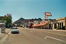
Ely is the largest town on U.S. Route 6 in Nevada. US 50 joins U.S. Route 6 at Ely. East of Ely, U.S. Routes 6 and 50 cross the Schell Creek Range, known for verdant forests and meadows, and for a large deer and elk population. The highway descends to Spring Valley, then crosses the Snake Range at Sacramento Pass, north of Nevada's second-highest mountain, Wheeler Peak, where a branch road accesses Great Basin National Park. Beyond the pass, US 6 passes just north of Baker, a Mormon farming community and reaches the Utah state line.
There are no services anywhere between Tonopah and Ely (a distance of about 168 miles). Although US 50 has the nickname "The Loneliest Road in America", US 6 has a solid case for the title; as Tonopah and Ely are the only cities it goes through in the 306 miles (492 km) it traverses in Nevada, with a combined population of just over 6,500, while US 50 boasts Carson City with over 50,000 and even Fallon alone out populates US 6, with over 8,000. In addition, there is not much traffic for US 6, as it ends 38 miles (61 km) south of the California and Nevada state line in the small town of Bishop, California at US 395 (with connections to the former western terminus of US 6 in Long Beach). The most heavily traveled portion of US 6 is the portion that is concurrent with US 95, as the latter route connects Las Vegas and Reno, the two largest metropolitan areas in Nevada.
History
US 6 was one of the original U.S. highways in the 1925 Bureau of Public Roads plan. It was commissioned in 1926, but was not extended west into Nevada until 1937. The alignment of US 6 in Nevada has remained largely unchanged since then.
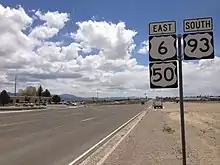
US 6 was routed entirely over existing state highways in Nevada. Between the California state line west of Montgomery Pass to Basalt, the highway was concurrently routed with State Route 10. From Basalt to Coaldale, the highway was concurrently routed with State Route 15. From Coaldale to Tonopah, the highway was concurrently routed with State Route 3. From Tonopah to Ely, the highway was concurrently routed with State Route 4 (also called the Midland Trail). From Ely to present-day Majors Place, the highway was concurrently routed with US 93 and State Route 7. From Major's Place to the Utah state line southeast of Baker, the highway was concurrently routed with State Route 14.
All of the concurrent state routes were removed from US 6 by 1939 except for SR 3 between Coaldale and Tonopah. Also, US 6 was realigned to enter Utah north of Baker instead of passing through the town. In 1940, SR 3 was replaced by US 95 between Coaldale and Tonopah. In 1954, US 50 was realigned between Ely and the Utah border and was concurrently routed over US 6.
Major intersections
- Note: Mileposts in Nevada reset at county lines; the start and end mileposts for each county are given in the county column.
| County | Location | mi[3] | km | Destinations | Notes |
|---|---|---|---|---|---|
| Mineral MI 0.00–15.20 [4][3]:13 [5]:154 | | 0.00 | 0.00 | Continuation into California | |
| Basalt | |||||
| Esmeralda ES 0.00–57.74 [lower-alpha 1] [6][3]:12 | | ||||
| | |||||
| Coaldale | Western end of US 95 concurrency | ||||
| | |||||
| Nye NY 0.00–132.02 [lower-alpha 2] [7] [3]:23,33 | Tonopah | 1.80 | 2.90 | Eastern end of US 95 concurrency[5]:160 | |
| | |||||
| Warm Springs | |||||
| Currant | |||||
| White Pine WP 0.00–101.88 [lower-alpha 3] [8][3]:33 | | 13.92 | 22.40 | [9][3]:33 | |
| Ely | 37.96 | 61.09 | Western end of US 50/US 93 concurrency[3]:33 | ||
| | 46.05 | 74.11 | Old SR 486 south | Serves Cave Lake State Park; MP is approximate, based on distance from MP 46.00[10] | |
| Majors Place | 65.4 | 105.3 | Eastern end of US 93 concurrency; MP is approximate, based on distance to SR-893 below | ||
| | 66.80 | 107.50 | [11][3]:33 | ||
| | 93 | 150 | Serves Great Basin National Park; MP is approximate, based on NDOT map[3]:33 | ||
| | 101.88 | 163.96 | Continuation into Utah | ||
1.000 mi = 1.609 km; 1.000 km = 0.621 mi
| |||||
See also
 United States portal
 U.S. Roads portal
References
- Nevada Department of Transportation (January 2017). "State Maintained Highways of Nevada: Descriptions and Maps". Retrieved May 14, 2017.
- "Nevada Named Highways 2015" (PDF). Nevada Department of Transportation. August 31, 2017. Retrieved June 3, 2019.
- Nevada Department of Transportation (May 2008). Maps of Milepost Location on Nevada's Federal and State Highway System by County (PDF). Archived (PDF) from the original on August 10, 2009. Retrieved September 10, 2009.
- "Mineral/Esmeralda county line" (JPG). www.floodgap.com. Cameron Kaiser. May 8, 2006. Retrieved November 23, 2018.
- "State Maintained Highways of Nevada : Descriptions and Maps" (PDF). Nevada Department of Transportation. January 2018. Retrieved November 23, 2018.
- "Esmeralda/Nye county line PM" (JPG). www.floodgap.com. Cameron Kaiser. July 1, 2006. Retrieved November 23, 2018.
- View west along U.S. Route 6 at the border of Nye County and White Pine County, Nevada (JPG). Wikipedia. July 17, 2014. Retrieved November 23, 2018.
- "White Pine county/Utah state line PM" (JPG). www.floodgap.com. Cameron Kaiser. July 2, 2006. Retrieved November 23, 2018.
- Google (November 23, 2018). "StreetView image of milepost US-6-WP-13.92" (Map). Google Maps. Google. Retrieved November 23, 2018.
- Google (November 23, 2018). "StreetView image of milepost US-6-WP-46.00" (Map). Google Maps. Google. Retrieved November 23, 2018.
- "US-6 eastbound junction with NV-893" (JPG). www.floodgap.com. Cameron Kaiser. July 2, 2006. Retrieved November 23, 2018.
- asellars for UDOT (August 11, 2017). Welcome to Nevada sign and MP "WP 101.88" – viewing northwest from northbound US-6/US-50 at UT/NV border (Map). Mapillary. Retrieved November 23, 2018.
- Official Road Map of the State of Nevada (Map). State of Nevada – Department of Highways. 1937.
- Official Road Map of the State of Nevada (Map). State of Nevada – Department of Highways. 1939.
- Official Road Map of the State of Nevada (Map). State Highway Department. 1940.
- Official Highway Map of Nevada (Map). Nevada Department of Highways. 1954.
External links
 Media related to U.S. Route 6 in Nevada at Wikimedia Commons
- AARoads: U.S. Highway 6 – Nevada
| Previous state: California |
Nevada | Next state: Utah |