Nevada State Route 663
State Route 663 (SR 663) was an east–west state highway in Washoe County, Nevada serving the Reno-Sparks area. The route was turned over to local control in 2010.
| ||||
|---|---|---|---|---|
| Oddie Boulevard | ||||
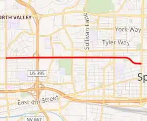
SR 663 highlighted in red | ||||
| Route information | ||||
| Maintained by NDOT | ||||
| Length | 2.491 mi[1] (4.009 km) | |||
| Existed | 1976–2010 | |||
| Major junctions | ||||
| West end | Sutro Street in Reno | |||
| East end | ||||
| Highway system | ||||
| ||||

Oddie Boulevard was named after former Republican U.S. Senator Tasker Oddie.
Route description
SR 663 began at the intersection of Sutro Street and Oddie Boulevard in the city of Reno. From there, the highway followed Oddie Boulevard eastward, passing under U.S. Route 395 to enter the city of Sparks. SR 663 ended at the intersection of Oddie Boulevard and Pyramid Way (SR 445).[1]
History
Prior to the renumbering of Nevada state highways in the 1970s, SR 663 was previously known as State Route 32A.
SR 663 was removed from the state highway system on March 16, 2010. However, as of late 2011, the portion of Oddie Boulevard at the US 395 interchange is still maintained by the Nevada Department of Transportation as a frontage road.[2]
Major intersections
The entire route was in Washoe County.
| Location | mi | km | Destinations | Notes | |
|---|---|---|---|---|---|
| Reno | Sutro Street | ||||
| Sparks | 2.49 | 4.01 | |||
| 1.000 mi = 1.609 km; 1.000 km = 0.621 mi | |||||
References
- Nevada State Maintained Highways: Descriptions, Index & Maps. Nevada Department of Transportation. January 2008.
- "State Maintained Highways of Nevada: Descriptions and Maps – Quarter 3 Update". Nevada Department of Transportation. October 2011. Archived from the original on 12 January 2012. Retrieved 26 Dec 2011.
