Nevado Tres Cruces
Nevado Tres Cruces is a massif of volcanic origin in the Andes Mountains on the border of Argentina and Chile. It has two main summits, Tres Cruces Sur at 6,748 metres (22,139 ft) and Tres Cruces Centro at 6,629 m (21,749 ft) and a third more minor summit, Tres Cruces Norte 6,206 m (20,361 ft). Tres Cruces Sur is the sixth highest mountain in the Andes. The area was first surveyed in 1883 by Francisco San Román and the Nevado Tres Cruces National Park was established in 1994.[2]
| Nevado Tres Cruces | |
|---|---|
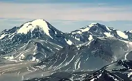 Tres Cruces from Ojos del Salado to the east. The higher south summit is on the left, the central summit on the right. | |
| Highest point | |
| Elevation | 6,748 m (22,139 ft) [1] |
| Prominence | 1,422 m (4,665 ft) |
| Naming | |
| English translation | Three crosses |
| Language of name | Spanish |
| Geography | |
| Parent range | Andes Mountains |
| Geology | |
| Age of rock | Pleistocene |
| Mountain type | Volcano |
| Volcanic arc/belt | Cordillera Claudio Gay,[2] Central Volcanic Zone |
| Last eruption | 28,000 years ago.[3] |
The volcano has an extended history of activity, going back at least 1.5 million years. A number of lava domes surround the complex and a number of craters lie on its summits. The main volcano is of rhyodacitic composition and has generated two major ignimbritic eruptions, one 1.5 million years ago and a second 67,000 years ago. The last eruption was 28,000 years ago, but the volcano is a candidate source for a Holocene eruption and it may become active in the future.
Climate and glaciation
The area has a desert climate, with nighttime temperatures below freezing and precipitation less than 29±14 mm in the local summer that quickly sublimates away, resulting in a lack of surface runoff and a barren landscape. The mean annual temperature is -2±4 degrees Celsius.[4] The area is persistently very windy.[2] The snowline altitude in the area is 5,800 m (19,000 ft), higher than the Pleistocene altitude of 5,500 m (18,000 ft).[5] 55[6] small relic glaciers with surfaces of less than 1 square kilometre (0.39 sq mi) exist above 5,500 m (18,000 ft) with moraines visible above 4,400 m (14,400 ft).[7] In 2000 a total ice surface of 1.1 km2 (0.42 sq mi) was reported on Tres Cruces.[8]
Geology
The whole complex has been active for 1.5 mya and has generated two large scale pyroclastic eruptions, a first one 1.5 mya occurred on the western side of the volcano. It is fairly thin and covers Pliocene lavas. Otherwise, rhyodacitic lava flows, lava domes and various ash and tephra deposits also belong to this volcano.[3][7] The three main volcanoes of the massif - Tres Cruces Sur (6,748 m (22,139 ft)), Tres Cruces Centro (6,629 m (21,749 ft)) and Tres Cruces Norte (6,206 m (20,361 ft)) formed along a local fault zone.[1] Tres Cruces Sur and Tres Cruces Centro are the sixth and eleventh highest mountains in South America.[2]
The massif delimits the Salar de Maricunga and has an extent of 10 km × 5 km (6.2 mi × 3.1 mi). The principal edifices are small but steep, rising 800–1,600 m (2,600–5,200 ft) above their bases. The northern cone is glacially eroded and has a crater 1 km (0.62 mi) wide. The central edifice has a crater 500 m (1,600 ft) and is inclined westward. The southern edifice is formed from an older western structure (0.8±0.5 mya) with two small craters and a glacial cirque, and an eastern edifice with a summit lava dome 2 km (1.2 mi) wide and basal lava flows. A cirque cuts the dome on the southeastern side and contains a small glacier. The whole edifice and the adjacent Miocene El Plateado volcano, as well as the western flank of neighbouring Ojos del Salado volcano, are covered with a thick layer of pumiceous ash fall, probably produced by the collapse of an eruption column.[7] Pliocene volcanic chain Cristi (2.5±1.3 mya[1]), Lemp (2.8±0.3 mya[1]) and Rodrigo (adakites 4.4 mya[9]) north and Puntiagudo south is largely buried beneath the massif.[7] Tomographic analysis of the area has indicated the presence of a large high-attenuation zone in the crust beneath Tres Cruces and the neighbouring Ojos del Salado volcano, which may indicate ongoing or incipient melting of the underlying crust.[10]
Lava domes
Two minor lava domes La Espinilla and El Indio are present. La Espinilla formed within the crater (150 m (490 ft) deep and 1.5–2 km (0.93–1.24 mi) wide) of an explosive eruption. This dome is 200–250 m (660–820 ft) wide and 45 m (148 ft) high and formed 168±6 ka K-Ar. El Indio is located on the side of La Espinilla away from the main massif and is larger and older (350±40 ka K-Ar) than Espinilla. Other older lava domes lie on the western flank (2.1±0.3 ka K-Ar).
A major dacitic lava dome (150–200 m (490–660 ft) thick and covering a surface of 3.5 km × 5.5 km (2.2 mi × 3.4 mi)) lies on the northwestern side of the massif, the vent is buried by younger deposits. The lava display flow banding and column jointing and has been K-Ar dated 1.4±0.4 mya.[7]
Recent activity
Activity in the southernmost volcano has been dated at 280,000±22,000 years ago. The complex is linked to the eruption of the Tres Cruces ignimbrite 67,000 years ago, also known as Pampa Blanca.[1] This ignimbrite is well exposed in the valley which separates the Tres Cruces and Ojos del Salado volcanoes, assuming thicknesses of 100 m (330 ft) with a basal flow 15 m (49 ft) thick.[3][7] There is evidence for three large glaciations on the mountain, the middle of which predates the Eemian warm period.[11]
The youngest activity occurred 28,000 years ago and formed the summit lava dome of the southernmost volcano.[3][7] Tres Cruces may have erupted during the Holocene; a tephra layer found in the Fiambalá region east of the volcano and dated to 1400-1270 and 1270–980 years before present may have originated at Nevado Tres Cruces. This eruption strongly affected the environment and societies of the Fiambalá area.[12]
Hazards
The volcano has an approximate rock generation rate of 0.13 km3/ka (0.031 cu mi/ka), lower than other arc associated volcanoes. Nevertheless, with eruptive episodes being separated by gaps of about 40,000 years between the last episodes, dangerous eruptive activity in the future is possible. However, the region surrounding the volcano is thinly populated, so major damage to infrastructure or danger to human life is unlikely.[7]
References
- Kay, Suzanne Mahlburg; Coira, Beatriz; Mpodozis, Constantino (2008). GSA Field Guide 13: Field Trip Guides to the Backbone of the Americas in the Southern and Central Andes: Ridge Collision, Shallow Subduction, and Plateau Uplift. 13. pp. 117–181. doi:10.1130/2008.0013(05). ISBN 978-0-8137-0013-7 – via https://www.researchgate.net/profile/B_Coira/publication/279723669_Field_trip_guide_Neogene_evolution_of_the_central_Andean_Puna_plateau_and_southern_Central_Volcanic_Zone/links/55f2234508aef559dc49341b/Field-trip-guide-Neogene-evolution-of-the-central-Andean-Puna-plateau-and-southern-Central-Volcanic-Zone.pdf.
- Rundel, Philip W.; Kleier, Catherine C. "Parque Nacional Nevado de Tres Cruces, Chile: A Significant Coldspot of Biodiversity in a High Andean Ecosystem" (PDF). The Newsletter of the Consortium for Integrated Climate Research in Western Mountains. US Forest Service. Retrieved 22 November 2015.
- Moreno, edited by Teresa; Gibbons, Wes (2007). The Geology of Chile. London: Geological Society. p. 154. ISBN 9781862392205. Retrieved 22 November 2015.CS1 maint: extra text: authors list (link)
- Dietze, Michael; Kleber, Arno (February 2012). "Contribution of lateral processes to stone pavement formation in deserts inferred from clast orientation patterns". Geomorphology. 139–140: 172–187. Bibcode:2012Geomo.139..172D. doi:10.1016/j.geomorph.2011.10.015.
- Haselton, Kirk; Hilley, George; Strecker, Manfred R. (March 2002). "Average Pleistocene Climatic Patterns in the Southern Central Andes: Controls on Mountain Glaciation and Paleoclimate Implications". The Journal of Geology. 110 (2): 215–216. Bibcode:2002JG....110..211H. doi:10.1086/338414. JSTOR 10.1086/338414.
- García, Ayôn; Ulloa, Christopher; Amigo, Gonzalo; Milana, Juan Pablo; Medina, Catherine (5 May 2017). "An inventory of cryospheric landforms in the arid diagonal of South America (high Central Andes, Atacama region, Chile)". Quaternary International. 438: 4–19. Bibcode:2017QuInt.438....4G. doi:10.1016/j.quaint.2017.04.033. ISSN 1040-6182.
- Gardeweg, M.C.; Clavero, J.; Mpodozis, C.; Perez de A., C.; Villeneuve, M. (4 August 2000). "El Macizo Tres Cruces: Un Complejo Volcanico Longevo Y Potencialmente Activo En La Alta Cordillera De Copiapo, Chile" (PDF). biblioserver.sernageomin.cl (in Spanish). Puerto Varas: Servicio Nacional de Geología y Minería. p. 295. Archived from the original (PDF) on 22 November 2015. Retrieved 22 November 2015.
- Masiokas, Mariano H.; Rivera, Andrés; Espizua, Lydia E.; Villalba, Ricardo; Delgado, Silvia; Aravena, Juan Carlos (October 2009). "Glacier fluctuations in extratropical South America during the past 1000years". Palaeogeography, Palaeoclimatology, Palaeoecology. 281 (3–4): 242–268. doi:10.1016/j.palaeo.2009.08.006. hdl:10533/130935.
- Kay, S. M.; Mpodozis, C.; Gardeweg, M. (7 August 2013). "Magma sources and tectonic setting of Central Andean andesites (25.5-28 S) related to crustal thickening, forearc subduction erosion and delamination". Geological Society, London, Special Publications. 385 (1): 303–334. Bibcode:2014GSLSP.385..303K. doi:10.1144/SP385.11. Retrieved 22 November 2015.
- Liang, Xiaofeng; Sandvol, Eric; Kay, Suzanne; Heit, Benjamin; Yuan, Xiaohui; Mulcahy, Patrick; Chen, Chen; Brown, Larry; Comte, Diana; Alvarado, Patricia (January 2014). "Delamination of southern Puna lithosphere revealed by body wave attenuation tomography". Journal of Geophysical Research: Solid Earth. 119 (1): 549–566. Bibcode:2014JGRB..119..549L. doi:10.1002/2013JB010309. hdl:11336/5005.
- Jenny, Bettina; Kammer, Klaus (1996). Climate Change in den trockenen Anden (in German). Verlag des Geographischen Institutes der Universität Bern. p. 67. ISBN 3906151034.
- Fernandez-Turiel, Jose-Luis; Ratto, Norma; Perez-Torrado, Francisco-Jose; Rodriguez-Gonzalez, Alejandro; Rejas, Marta; Lobo, Agustin (1 April 2016). "A large eruption convulsed in prehistoric times an extensive area of Catamarca, Southern Central Andes, NW Argentina". Egu General Assembly Conference Abstracts. 18: EPSC2016–10120. Bibcode:2016EGUGA..1810120F.
External links
- Biggar, John (2020). Andes: A Guide for Climbers and Skiers (5th ed.). Castle Douglas (Scotland): Andes. ISBN 978-0953608768.
- Global Volcanism Program: Nevado Tres Cruces
- Andes Handbook (Spanish)
- Tres Cruces (Spanish)