New Hampshire Route 142
New Hampshire Route 142 (abbreviated NH 142) is a 19.688-mile-long (31.685 km) north–south state highway in northern New Hampshire. The highway runs between Franconia in the White Mountains Region to Dalton in the upper Connecticut River valley.
| ||||
|---|---|---|---|---|
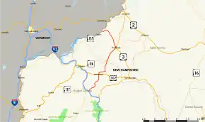 Map of northern New Hampshire with NH 142 highlighted in red | ||||
| Route information | ||||
| Maintained by NHDOT | ||||
| Length | 19.688 mi[1] (31.685 km) | |||
| Major junctions | ||||
| South end | ||||
| ||||
| North end | ||||
| Location | ||||
| Counties | Grafton, Coos | |||
| Highway system | ||||
| ||||

The southern terminus of NH 142 is at the junction with New Hampshire Route 18 in Franconia. The highway winds north through Bethlehem and Whitefield, then turns northwest to Dalton. NH 142 runs concurrently with New Hampshire Route 116 for 3.659 miles (5.889 km) in Whitefield. The northern terminus is in Dalton at New Hampshire Route 135, the Connecticut River Road.
Major intersections
| County | Location[1][2] | mi[1][2] | km | Destinations | Notes |
|---|---|---|---|---|---|
| Grafton | Franconia | 0.000 | 0.000 | Southern terminus | |
| 0.072– 0.126 | 0.116– 0.203 | Exit 37 on I-93 north | |||
| Bethlehem | 5.338 | 8.591 | Southern end of concurrency with US 302 | ||
| 5.367 | 8.637 | Northern end of concurrency with US 302 | |||
| Coos | Whitefield | 10.200 | 16.415 | Southern end of concurrency with NH 116 | |
| 13.812 | 22.228 | Southern end of concurrency with US 3 | |||
| 13.859 | 22.304 | Northern end of concurrency with US 3 / NH 116 | |||
| Dalton | 19.688 | 31.685 | Northern terminus | ||
1.000 mi = 1.609 km; 1.000 km = 0.621 mi
| |||||
References
- Bureau of Planning & Community Assistance (February 20, 2015). "NH Public Roads". Concord, New Hampshire: New Hampshire Department of Transportation. Retrieved April 7, 2015.
- Bureau of Planning & Community Assistance (April 3, 2015). "Nodal Reference 2015, State of New Hampshire". New Hampshire Department of Transportation. Retrieved April 7, 2015.
External links
This article is issued from Wikipedia. The text is licensed under Creative Commons - Attribution - Sharealike. Additional terms may apply for the media files.